Hexagon Mining Leica scanning improves safety in Brazilian gold

Since the first colonisers arrived back in the 1500s, precious gold reserves have been explored in the dry lands of central and southeast Brazil. From pickaxes and manual classifiers to automatised extractors, with pressure washers and conveyor belts, the modern gold underground mining exploration has one more precious element to preserve: lives. Miners are in constant risk with galleries kilometres deep underground; daily dynamite explosions; and unstable walls and tunnels
The risk increases when stopes must be surveyed. Stopes are the result of multi-level galleries union after successive explosions. These rock-surrounded rooms are unstable, with loose sterile ore falling and walls collapsing; so risky, in fact, human access inside stopes is forbidden by safety engineers on site. Surveying control of these excavations requires high-risk management.

Precise dimension and volume determinations are key to a successful gallery excavation plan and the general mine explorations plan. AngloGold Ashanti, a leading global gold producer, operates four mines in the Brazilian states of Minas Gerais and Goiás. At almost 400 m deep, the company’s Córrego do Sítio 1 Mine needs detailed information about its galleries and stopes for

  • Volume calculations
  • 3D models creation
  • Mine reconciliation

Traditionally, stope surveys were performed with total stations. These surveys were done as quickly as possible since the surveyor is in a high-risk scenario inside the stope’s structure. A few points were collected and the dimensions of the space interpolated and generalised. With the use of laser scanning, though, higher data quality became available to mine planners.

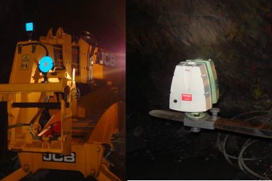
Using the Leica ScanStation C10, the procedure consists of pulling the laser scanner inside the stope using mechanical arms, small trucks, forklifts or even wheelbarrows. This places the operator safely out of harm’s way at the end of the gallery. Leica Geosystems is part of global company Hexagon Mining.

Using a Leica CS15 controller to remotely operate the wireless-enabled ScanStation, a set of targets are also collected and coordinated to the mine coordinate systems with a Leica TS06 total station. A few minutes later, the data is processed in Leica Cyclone REGISTER software. The stope is then modeled within seconds in 3DReshaper.

With laser scanning, a time saving of up to seven hours, compared to previous traditional surveying techniques, is achieved. Whereas processing a stope survey previously could take up to eight hours, the mine technicians can now extract it in less than one hour using Cyclone, 3DReshaper and other Leica Geosystems software solutions.

“The Leica ScanStation not only improves the operation regulatory conformity for safety, but it also boosts productivity and gives us huge time savings,” said Ravel Júlio da Fonseca, Supervisor at AngloGold Ashanti. “Our teams can survey more locations, optimising both ore extraction and mine reconciliation. And the level of details on galleries is so high that even outcropping ore and cabling can be spotted, benefiting not only the survey teams but also the rock mechanics team on its field project analysis and layout. 

More importantly, though, this technology enables the mine to reach its top priority – safety. In underground mining, safety is a top requirement. Knowing the environment around you is fundamental for ultimate security and extraction planning. Laser scanning exposes fewer miners to dangerous environments, for less time, while exceeding surveying and extractions demands.