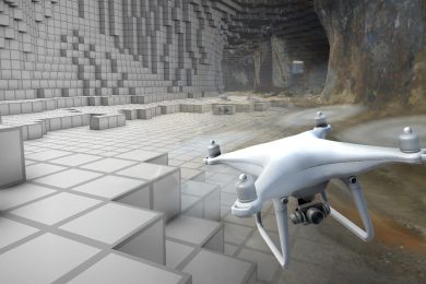
Mining3 is commercialising a 3D-based software platform that can create and simulate a virtual mine. By positioning precisely where things are underground, it opens up opportunities such as controlling robots and tracking movement of ore of different grades. “Imagine being able to control a vehicle or drone inside a mineshaft from anywhere in the world without fear of it crashing into mine walls or workers. Picture being able to track the metal in a car chassis from ore to finished product. Or, consider the ability to store data so that it interacts automatically with information from other sources to provide a more profound understanding of a mine and its grade. Such things are fast becoming possible using a new 3D-based internet platform known as VoxelNET.”
The technology has been developed through Mining3 — an industry-funded partnership between industry, original equipment manufacturers (OEMs) and several research groups that include CSIRO. “VoxelNET is all about a more efficient way of storing, analysing, sharing and visualising spatially-based information,” CSIRO 3D system researcher and Mining3 technology leader, Charlotte Sennersten, says. “It is ideal for spatially-based enterprises, but particularly for the mining and minerals industries.”
The internet systems currently used to store, analyse, transmit and display information was built for handling 2D text and documents. It has to be modified with software plug-ins to work and display information in 3D and VoxelNET supports this directly. VoxelNET can be used to generate a virtual mine and simulate its operation in 3D. It stores remote sensing information on the fly and enables the tracking or control equipment or material remotely. It’s also able to be shared and accessed by different devices simultaneously and can pull data from a range of sources such as sensors, CAD files and point cloud devices.
The virtual 3D space is made up of voxels, an equivalent to 2D pixels on a screen. Voxels are cubes, the size of which can be defined to fit the task at hand. Each voxel in VoxelNET can be precisely located. The voxels can hold information such as density, ore grade, rock hardness, or even safety regulations and legal requirements. They can be programmed to store, integrate and cross-correlate data from many different sources. They can also act autonomously to find and process data, and to interact with each other in precise ways.
The voxels come in several different varieties. “Spatial voxels”, for instance, are linked directly to a precisely defined one-metre by one-metre grid of the Earth’s surface — from five kilometres underground to 20 km above ground. They can be used to simulate and connect to reality. Whereas, the matter within “material voxels” can be labelled and traced wherever it moves. Every step and change can be accounted for using the new blockchain technology. The provenance of ores of different grades can be sourced and traced to enable precise planning for mining with lower impact.
Voxels and the data they contain can also be subject to different defined layers of security. Broad access can be allowed to some information or simulations, while access to more confidential information can be restricted. Data can be spatially tagged or completely anonymised. The platform already allows input of drillhole data, real-time vehicle data, remote-sensing data and 2D and 3D maps by a single client or user. The applications supported include simulation, remote vehicle control and interactive visualisation.
At present, VoxelNET is only available through consultation with researchers at Mining3. Next year, it is hoped it will be released as a commercial product. Mining3 is looking at how to support its ongoing development into a cloud-based distributed platform.