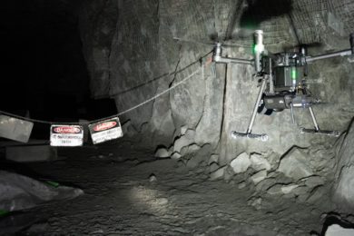
Emesent says it has announced a major breakthrough in the journey to fully autonomous drone flight systems, with the launch of Autonomy Level 2 (AL2) for Hovermap, the world’s first plug-and-play payload for industrial drones that provides autonomous beyond line of sight, GPS-denied flight.
Building on Emesent’s Hovermap simultaneous localisation and mapping autonomous (SLAM) flight system, AL2 enables compatible drones to fly beyond communications range and venture beyond line of sight into unmapped areas, it says.
“The AL2 technology enables companies to rapidly map, navigate, and collect data in challenging inaccessible environments such as mines, civil construction works, telecommunications infrastructure, and disaster response environments,” Emesent said.
Andrew Rouse, Chief Technology Officer at PYBAR Mining Services, a user of the Hovermap payload, said: “AL2 is a game changer for us. It takes Hovermap into places that even the most experienced pilots would fear to venture, enabling us to obtain critical data in real time without risking the machine. We’re already seeing great benefits to our workflow and operational efficiency from using the new technology.”
Emesent’s technology builds on a decade of award-winning research by CSIRO’s Robotics and Autonomous Systems group into drone autonomy and 3D LiDAR-based SLAM techniques.
Customers around the world have been using Hovermap’s Autonomy Level 1 capability for almost two years, safely mapping challenging GPS-denied areas within line of sight. Moving to AL2 means the drone can self-navigate and avoid obstacles beyond line of sight, while being operated from take-off to landing from a safe distance, the company explained.
The system processes data on-board in real time to stream a 3D map of the environment back to the operator’s tablet, providing instant and detailed insights into the surrounding area, as well as any potential hazards. The entire mission from take-off to landing is conducted by interacting with the live view 3D map, allowing stopes to be mapped with just a few taps, Emesent claims.
AL2, according to Emesent, will give industrial customers:
- Improved safety, with the ability to fly beyond line of sight keeping workers away from hazardous environments and better data insights informing how to make mines and other environments safer;
- Cost optimisation, as it is quicker to scan environments and the technology requires less skill to operate;
- Reduced downtime, with the drone able to quickly and easily map inaccessible underground excavations, with minimal disruption to production;
- Enhanced visibility into environments, with real-time point clouds delivered directly to the pilot’s tablet, enabling them to interact with and explore the scan data as they operate the aircraft; and
- Ease of operation due to its “Tap-to-Fly” and “Guided Exploration” functionalities, and various fail safes, including automatic return to home on low battery and automatic landing at critical battery level.
AL2 is currently compatible with several DJI Enterprise drones including the new DJI Matrice 300 RTK, according to Emesent.
“Emesent has worked closely with DJI to ensure close compatibility and integration of autonomous functionality such as AL2 with the drone’s flight controls,” it said. “Further compatibility with other drone models is planned following the launch.”
Dr Stefan Hrabar, CEO and co-Founder of Emesent, said: “This is a huge step forward for drone autonomy and a massive benefit to industries like mining, civil construction, and emergency response.
“With the intelligence to navigate environments without a prior map, customers can use the system to carry out complex missions, secure the safety of personnel, and drive greater efficiency in their operations.”