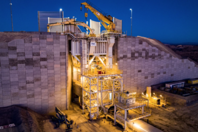
Australian mid-tier gold mining company Evolution owns and operates four mines in Australia and one in Ontario, Canada. Located 600 km east of Perth, the Mungari underground operation produces more than 125,000 oz of gold a year. Mungari’s gold mineralisation occurs in a zone 70 m wide by 400 m long (230 by 1,300 ft), with ore lodes two to 20 m (6 to 65 ft) thick. The site uses a narrow top-down bench stoping with paste fill mining method. Until February 2020, a traditional cavity monitoring system (CMS) was used to scan stopes. This data gathering method was time consuming and posed a safety risk to personnel performing the surveys.
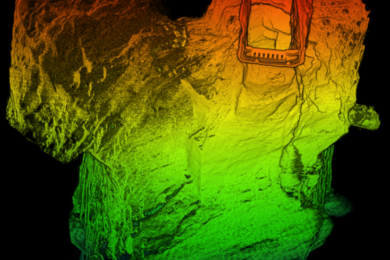
Data coverage and quality were poor, forcing mine engineers and planners to make decisions on stope design based on limited and potentially inaccurate information – increasing the risk to the economics of the stope. Mungari management sought a stope mapping solution that delivered rich, shadowless data and could be deployed quickly and easily by onsite personnel. In March 2020, Evolution’s survey team purchased a Hovermap LiDAR mapping system for the Mungari site. Hovermap was originally intended for mapping stopes only. However, the team soon realised the level of data quality and coverage it could provide made it an ideal choice for other mapping applications. Its use escalated and it is now the preferred tool for mapping all voids at Mungari.
The survey team, no longer limited by obstructions or corners, can simply fly Hovermap, mounted to a DJI M210 drone, into a void to capture the data they need. Point cloud data captured by Hovermap is imported directly into Deswik.AdvSurvey using a semi-automated workflow developed by Deswik to link the two solutions. The data is georeferenced, cleansed, and validated, ready to be delivered as a detailed model, free of shadows and artefacts, to other teams, in less than five minutes. “Thanks to Emesent’s recent partnership with Deswik we are now able to integrate the data processing with our existing CAD package on site, resulting in smoother workflows that are easy to adopt” said Matt Jones, Senior Surveyor, Evolution Mining.
Using Hovermap to scan voids at Mungari allows mine personnel to plan and manage stopes more effectively. The insights provided by Hovermap help to eliminate ‘guess work.’ Armed with quality data, the technical services team can tackle stope bridging events and dilution due to over-break with a much better understanding. Even though the survey team had limited drone experience, they quickly mastered Hovermap’s easy-to-use interface and developed the competence to fly in challenging environments. This makes it an efficient and cost effective means of collecting data.
At the end of each month, the team no longer needs to splice shadowed CMS data to calculate stope shapes, as Hovermap provides close to 100% data coverage. Armed with accurate stope data, it only takes them a few minutes to import, georeference and deliver a void model for reconciliation. Access to this high quality, accurate data is enabling Evolution to optimise the Mungari mine plan. Evolution also uses Hovermap at its Red Lake Operations.
“Hovermap has been an unprecedented success in our eyes. This game changing piece of technology allows us to make much more informed decisions about our underground voids, with data collection that is orders of magnitude above existing methods, yet with shorter data collection and processing time. The teams on site have been totally blown away by the level of detail they now have access to, and consider it an essential piece of equipment,” says Jones.