Tag Archives: Exyn Technologies

Maestro heads for the IoT edge with new future-proofed solutions

Driving out capital expenditure and standardising IIoT infrastructure have been the two key pillars propelling Maestro Digital Mine forward, and, 10 years after its formation, these two drivers are on show with its latest launches at the SME MineXchange Annual Conference & Expo in Salt Lake City.

Over the last decade, the company has become synonymous with improving underground mine ventilation safety as well as reducing blast re-entry times, with an offering that includes air quality stations, automated regulators, and “fail-safe” LED displays. Yet, Maestro’s core is IIoT devices and last mile digital networks for underground mines.

Michael Gribbons, CEO and Co-founder for Maestro, says the company’s production of “IIoT solutions” pre-dates the popular use of this acronym, with its big launch in Salt Lake City set to take Maestro into new “edge-based” territory that will allow it to cope with multiple communication protocols or artificial intelligence-led process miners look to leverage over the next decade.

He explained to IM: “We have re-envisioned and redesigned both our hardware, embedded firmware and external software to allow greater flexibility and capabilities for today and the future; the platform, if you will.”

This current hardware platform has, among other things, underpinned the success of its Vigilante AQS™, which was created to solve applications for mine ventilation monitoring and control.

“Every year, Vigilante customers kept asking for different capabilities, and we have said yes to these requests until we couldn’t.” Gribbons said. “We ran out of hardware space – we just couldn’t do the things the clients were asking anymore, forcing a major platform redesign that is now shipping.”

This constant cycle of improvement has already led Maestro into the realm of dust monitoring and regulator control. It also saw the company devise products and solutions that eradicated the need for expensive PLCs, customer panels and fabrication. Its plug-and-play philosophy, in turn, has reduced the amount of engineering required to install and monitor these solutions.

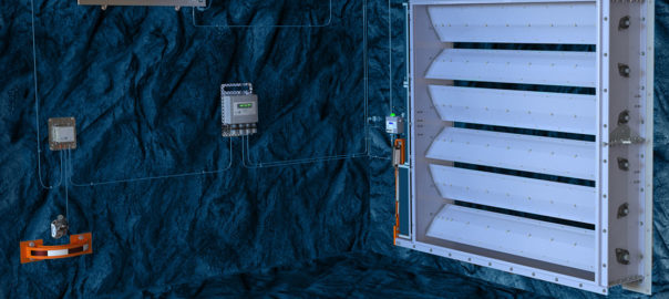
“For example, legacy analogue actuators are now being driven out of the equation by coupling ModuDrive™ actuators to automate regulators allowing significant capital expenditure reductions and improved diagnostic monitoring by using edge-based embedded IIoT technologies,” Gribbons said. “The mining industry is following other industries by applying modular construction where proven solutions can be selected and applied instead of the typical one-time custom engineering design and build where individual components are collated and customised on an individual basis. The main advantages of applying modular construction is schedule acceleration and capital expenditure reduction.”

Gribbons sees the new platform – a combination of hardware, user interface, on-premise and cloud-based software allowing data to be stored and trended by the customer as they choose – being able to take advantage of “true edge-based technology” to make better and quicker decisions.

The new platform installed on the Vigilante AQS, SuperBrite™ Marquee display, MaestroFlex™ regulator and ModuDrive actuator are on display at the SME conference.

Looking past the fixed automation infrastructure Maestro has made its name on, the company is now embedding its expertise into more mobile solutions that the industry has been taking a liking to, namely drones and unmanned robots.

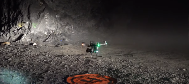
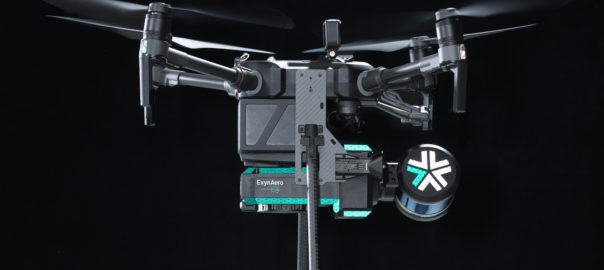
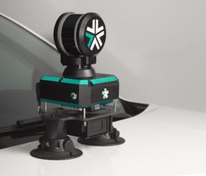
Also featured on the Maestro stand – and the Exyn Technologies stand – at the event is an aerial drone with a Maestro gas monitoring IIoT device fitted on it.

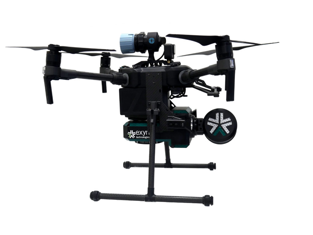
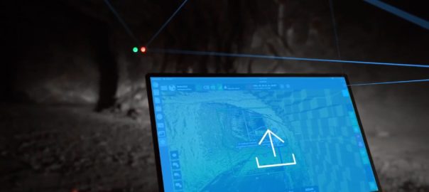
This new gas monitoring drone, which will integrate critical gas sensors onto the ExynAero™ and ExynPak™ platforms, is, effectively, the “quickest and safest mobile gas monitor on the planet”, Gribbons remarked. “The drone is able to automatically launch and log targeted gases directly on the point cloud in any confined area without deploying mine rescue personal with Scott Air-Paks. Again, we are improving worker safety and accelerated time to obtain accurate data in emergency conditions or for more granular data at the headings for reducing blast re-entry times.”

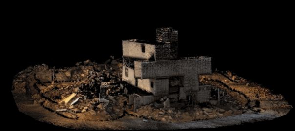
Powered by ExynAI’s multi-sensor fusion capabilities, gas sensor readings are captured while the robot is in flight and displayed in real-time via a ruggedised tablet, Exyn explained. These sensor readings are saved with precise coordinates in a high-fidelity point cloud that can be exported and examined in a variety of mining software.

These mobile applications will remain a minority interest for Maestro, but it offers the company another way to influence the underground mine safety dynamic and ensure it stays loyal to its “we leave no one stranded” brand promise.

Such collaborations are nothing new for Maestro. Just last year, it teamed up with Howden to integrate its IIoT solutions into the Ventsim CONTROL ventilation optimisation software, while, in 2020, it brought the Plexus PowerNet™ last mile communication network to MacLean Engineering’s Sudbury test mine and Dynamic Earth’s educational mine to enable continuous connectivity underground.

Gribbons said the company has also just worked with Spain-based Zitron on designing large 4 x 4 m MaestroFlex™ regulators on underground booster fans at a major gold mine in Canada.

All these partnerships are part of the company’s recipe for success.

“We’ve progressively eliminated elements of underground mine automation infrastructure to simplify and allow for the future automation of mining,” Gribbons said. “This is working; the clients continue to return, and we stay true to our core purpose of enhancing lives by the pursuit of productivity and safety excellence.”

Exyn Technologies accelerates colourised 3D model capture with ExynPak

Exyn Technologies has unveiled what it says is the world’s first real-time colourised point cloud visualisation on a handheld LIDAR scanner, the ExynPak™.

This accomplishment marks one of Exyn’s many contributions to autonomous robotics across several industries including mining, infrastructure inspection and construction, it said.

Even in its early beta phase, ExynPak users can capture precise, colourised 3D models 20-30 times faster than a traditional stationery tripod or terrestrial scanner, according to the company. Powered by ExynAI™, the ExynPak ‘drapes’ real-time RGB information captured through two hemispherical fixed cameras onto point clouds created by a gimballed Velodyne LIDAR Puck LITE, providing operators a complete colourised 360º view of their environment.

Coming with a three-hour battery life, the ExynPak is capable of capturing dozens of scans in a single shift with a real-time feed ensuring maximum coverage, Exyn said. And further refinement through Exyn’s proprietary post-processing pipeline, ExSLAM, can correct drift to circa-0.1% per distance travelled.

Jason Derenick, CTO, said: “We’ve seen photogrammetry and other post-processed LIDAR scans colorise point clouds through photos and/or RGB data, but this is the first time colourised point clouds have been streamed to an operator in real time. Even in its BETA phase, we’re thrilled with what the team has created.”

The untapped potential of high-fidelity, precise 3D models has already revolutionised workflows in geological studies (mining) and will continue to revolutionise workflows in construction, reality capture, digital twinning, industrial inspection and more, according to Exyn. Equipped with a colorised ExynPak, a one-to-two person surveying team will be capable of capturing entire structures, tunnels and GPS-denied environments in a matter of hours, rather than days or even weeks.

Nader Elm, CEO: “The ExynPak is a powerful new tool with broad applications in many ‘physical’ industries such as construction, infrastructure development and inspection, mining and much more. You can set it down, initialise and begin capturing a realistic 3D model of your environment in minutes and with minimal training.”

Burgex adds ExynPak LiDAR capabilities to mine mapping offering

Burgex Inc Mining Consultants has announced newly acquired in-house capabilities to provide high accuracy mapping of surface and underground mine workings with the addition of the ExynPak from Exyn Technologies to its fleet of mining and mineral exploration solutions.

With a gimballed Velodyne LiDAR sensor and the ability to provide real-time 3D mapping with survey-grade accuracy, the ExynPak is the leader in high accuracy handheld mapping for mining and exploration applications, according to Burgex. Simultaneous Localisation and Mapping (SLAM) provides accurate, survey-grade 3D mapping in real-time without the use of GPS, it added. This delivers precision mapping in underground mining environments that have been traditionally difficult to map using modern methods.

“The ability to map underground and surface mining workings in high resolution provides an enormous advantage to mine planning and mineral exploration projects,” Burgex said. “With LiDAR capabilities of over 600,000 points per second and a 360° horizontal field of view, it is possible to quickly identify slopes, faults and other geological features in real time. In addition to generating <3 cm accuracy point clouds in real time, the ExynPak is also equipped with two FLIR Chameleon3 RGB cameras that are capable of colourising points – providing yet another layer of functionality to geologic mapping and mine planning projects.”

Leveraging portable LiDAR with aerial data collection provides a new level of flexibility in modelling for mining and mineral exploration projects that is not offered at many, if any, other mining consulting firms in the US, Burgex said. Combined with aerial mapping, the Burgex team can pin underground and surface LiDAR surveys to geo-referenced base surveys and maps – creating a completely modelled project that can be used for mine planning, exploration programs, and more.

Additionally, Burgex Mining Consultants has recently added a DJI Matrice 300 RTK (M300) to its fleet of UAVs, providing even greater capabilities for aerial data collection.

“Not only can the M300 collect data more efficiently that other UAVs, but it can also simultaneously carry up to three payload sensors,” the company said. “The M300 has a max transmission range of up to 9.3 miles (15 km) with a 55-minute maximum flight time. The IP45 water and dust protection ratings and expanded operating temperatures will enable operation in a broader range of field conditions.”

Stuart Burgess, CEO and Co-Founder of Burgex Inc, said: “We are very excited about the addition of this new equipment and the new services we will be able to provide for our clients. From underground to surface, we’ll be able to map and model projects quickly and with centimetre accuracy, which is something that used to be very difficult and expensive to achieve, especially in underground environments. These new tools represent the next generation of mining and mineral exploration advancements.”

Sandvik, Exyn combine capabilities in new autonomous mine inspection concept

Sandvik Mining and Rock Solutions and Exyn Technologies have furthered their strategic partnership looking at new horizons of mine autonomy with the introduction of the Sandvik Exyn inspection concept.

An autonomous mapping solution that can co-operate with autonomous machines without stopping production, according to Jussi Puura, Research and Technology Development, Digitalization Lead at Sandvik Mining and Rock Solutions, the pair launched the concept at MINExpo 2021, in Las Vegas, today.

Back in March, the companies expanded the strategic partnership they initially signed in 2020, looking to integrate drone-based data processed using Exyn’s on-board 3D mapping technology with Sandvik’s OptiMine® Mine Visualizer solution for analysis and optimisation of underground mining production and processes.

The integration, the pair said, allows mining customers to benefit from comprehensive underground aerial 3D mapping with visualisation that increases overall transparency of mining operations – including for GPS-denied, hard-to-reach, or hazardous areas, or locations that would be time-consuming to survey and inspect using conventional methods.

Exyn and Sandvik deployed this integrated solution at gold exploration and development company Rupert Resources’ Pahtavaara project in Finland, using the ExynAero drone to autonomously create a 3D point cloud of an underground stope. This 3D data was then uploaded to Sandvik’s OptiMine Mine Visualizer and georeferenced to the CAD mine model for further analysis and visualisation.

The companies said back then that it planned to further develop the partnership to integrate more hardware and software systems, and they have now done just that, premiering the new concept at this week’s MINExpo.

The concept works by an operator indicating the area they want surveyed on the OptiMine 3D visual screens, and then ordering that survey. The ground-based machine then starts the assigned mission at a time that is convenient and does not cause any production interruptions.

After deployment and when the wheeled inspection vehicle cannot drive any further, the on-board autonomous UAV is deployed to complete the survey of the area of interest.

When the survey mission is complete, the UAV lands on the ground-based robot and both return to the charging station to await the next mission. The data from both vehicles is then automatically uploaded to the Sandvik Data Management Server, part of the OptiMine suite.

The server processes all data automatically and georeferences it to existing data in the server, using the survey team’s data as ‘anchors’ and ‘ground rules’ for the new data. The data is automatically merged into an updated model of the mine.

In addition to merging and ‘cleaning’ the data, the system can be set up to run automated analysis on the data. For example, automatic reports on change detection, shrinkage detection, road condition, etc can be run after every survey.

The solution results in better planning, increased safety and less production stops, according to the companies.

Exyn Technologies expands drone distribution with World Class Mining pact

Exyn Technologies has continued to build its network of distributors, announcing a partnership with Mexico-based World Class Mining to bring autonomous drones to the Mexican mining market.

World Class Mining offers representation to foreign companies, introducing their products and services into the local mining sector.

In the last year, alone, Exyn has signed agreements with OPTRON, NSS and C.R. Kennedy to expand its distribution network across Africa, Canada and Australia.

With the assistance of ExynAero, an autonomous and self-piloting aerial drone, the partnership was created to support WCM in its ongoing efforts to increase safety measures for Mexican miners and to make advancements in data collection, Exyn said. ExynAero allows for comprehensive underground aerial 3D mapping with progressive visualisation that increases overall transparency of mining operations − including for GPS-denied, hard-to-reach, or hazardous areas, or locations that would be time-consuming to survey and inspect using conventional methods.

Juan Gonzalez Serrano, Head of Business Development at WCM, said: “We are convinced that 3D mapping solutions Exyn has to offer are the best option available worldwide for our customers in Mexico.”

Nader Elm, CEO and Co-Founder of Exyn Technologies, said: “We’re very proud to expand our partnership with World Class Mining, and to deliver the key benefits of safety and operational efficiency to all the humans involved in the Mexican mining industry. By offering world-class software and technology, we have given them the ability to map areas underground they could never before reach. Our end goal is to be an integral part of fully autonomous mining operations.”

Exyn Tech to bring autonomous drones to Africa with help of OPTRON

Exyn Technologies has announced a partnership with OPTRON, a leading supplier of the latest geospatial technology in the African market, as its first ever distributor in Africa.

Together, this partnership will highlight the availability of Exyn’s underground drone products in the African market to bring safer working conditions for the local mining industry, the company said.

The ExynAero, an autonomous and self-piloting aerial drone, was the industry-leading product that helped open the door to the relationship, according to Exyn. The company’s full-stack solution enables flexible deployment of single or multi-robots that can intelligently navigate and dynamically adapt to complex environments in real-time.

With OPTRON supplying and supporting products in most countries across sub-Saharan Africa, directly and indirectly with the assistance of a select network of resellers and agents, it is perfectly positioned to help Exyn expand its product across the continent, Exyn said.

Sean Dane, Head of New Business Technology & Development at OPTRON, said: “We are excited to be part of the Exyn dealer network. Their ground-breaking autonomous drone system is the ideal solution to safely and easily capture accurate 3D data in the hazardous underground mining environment.”

Exyn says it brings a new level of autonomy never before seen in Africa, as well as new portable mapping solutions available in the African market, more efficient and safer mapping practices, easy-to-use high tech tools, beyond-line-of-sight data capture, and increased workflow and on-site data processing. These features will enhance suitability for the underground mining environment, and infrastructure inspection and maintenance, and will offer increased safety to mining operations.

Nader Elm, CEO & Co-Founder of Exyn Technologies, said: “We’re excited to be expanding into new markets by replacing legacy technology with a simple, autonomous solution. Safety is the number one concern in mining and I’m confident that, through our partnership with OPTRON, we’re one step closer to achieving fully autonomous mining operations.”

Exyn’s underground drones to get more Canadian air time with NSS agreement

Exyn Technologies, a pioneer in autonomous aerial robot systems for complex, GPS-denied industrial environments, has announced a partnership with NSS (Northern Survey Supply) to distribute Exyn’s underground drone products in the Canadian market through NSS Canada.

Canadian underground mining companies looking for ways to increase safety and efficiency by using cutting-edge autonomous robots now have a viable solution for their needs, Exyn said.

“Exyn offers a full-stack solution that enables flexible deployment of single or multi-robots that can intelligently navigate and dynamically adapt to complex environments in real time,” it explained.

ExynAero, an autonomous and self-piloting aerial drone, operates using a high level of autonomy (Autonomy Level 4) to access complex, GPS-denied environments, predominantly within the mining industry. It replaces legacy CMS systems for safer and more efficient workflow.

Nader Elm, CEO and Co-Founder of Exyn Technologies, said: “We’re proud to expand our worldwide footprint with this partnership by empowering surveyors with a suite of highly accurate cavity monitoring tools. More Aeros & Paks in the field means more safety for mine workers in Canada and beyond.”

The thematic synergy of the partnership can be seen in the prioritisation of safety and efficiency from both companies, they said.

NSS Canada provides tools and solutions, such as MOSS (Miner Operated Survey System), to ensure underground procedures can be done safer, faster and with more accuracy. ExynAero autonomous drones, meanwhile, allow data to be collected without humans subjecting themselves to potentially hazardous locations and situations.

“The partnership allows mining customers to benefit from comprehensive underground aerial 3D mapping with progressive visualisation that increases overall transparency of mining operations – including for GPS-denied, hard-to-reach, or hazardous areas, or locations that would be time-consuming to survey and inspect using conventional methods,” the companies said.

Bruno Lalonde, President, NSS Canada: “NSS Canada believes in the rapid adoption of cutting-edge technologies that can revolutionise the mining industry by increasing safety, speed, and accuracy. Exyn Technologies is a pioneer in the industrial drone space, whose autonomous drone technology reduces the possibility of human error in potentially dangerous environments. Our mutual dedication to safety and innovation through technology is why we believe this is the perfect partnership!”

Exyn and Sandvik OptiMine auto drone integration tested at Rupert Resources project

Exyn Technologies has announced the expansion of its strategic partnership with Sandvik Mining and Rock Solutions to integrate its data into Sandvik’s analytics and process optimisation suite, OptiMine®.

By synthesising critical data and capabilities, Exyn and Sandvik are helping mining customers transform their underground operations to be safer, more productive and more efficient, the companies say.

Back in July, the two companies signed an agreement to work together “to provide efficient solutions for mapping and visioning underground mines, which will make a substantial difference when it comes to mine locations that are hazardous, hard to reach or conventionally time-consuming to survey and inspect”.

In the latest release, the two said: “Using Exyn’s industrial-grade autonomous drone, ExynAero, mining companies can harness completely pilotless flight to access impossible-to-reach data with maximum safety. The data collected is processed using Exyn’s on-board 3D mapping technology – powered by ExynAI – which is then integrated with Sandvik’s OptiMine Mine Visualizer solution for analysis and optimisation of underground mining production and process.”

The partnership allows mining customers to benefit from comprehensive underground aerial 3D mapping with progressive visualisation that increases overall transparency of mining operations – including for GPS-denied, hard-to-reach, or hazardous areas, or locations that would be time-consuming to survey and inspect using conventional methods, according to the companies.

Exyn and Sandvik deployed this integrated solution at gold exploration and development company Rupert Resources’ Pahtavaara project in Finland, using the ExynAero drone to autonomously create a 3D point cloud of an underground stope. This 3D data was then uploaded to Sandvik’s OptiMine Mine Visualizer and georeferenced to the CAD mine model for further analysis and visualisation.

David Hallett, Vice President, Business Unit Automation, Sandvik Mining and Rock Solutions, said: “This step in our partnership with Exyn is critical. Our teams have been working closely together to ensure the connection between Exyn and Sandvik’s systems would be seamless and easy for operators to use. When this feature gets rolled out to the market as part of OptiMine, it will allow our customers to analyse Exyn’s high-resolution, aerial maps in OptiMine.

“After this demonstration, we look forward to further developing our partnership and integrating our hardware and software systems in the coming months.”

Nader Elm, CEO and Co-Founder of Exyn Technologies, added: “We’re very proud to expand our partnership with Sandvik and to deliver the key benefits of safety and operational efficiency to all the humans involved in the mining industry.

“By offering world-class software and technology, we have given customers the ability to map areas underground they could never before reach. Our end goal is to be an integral part of fully autonomous mining operations and I’m confident that through our partnership with Sandvik, we’re one step closer.”

Exyn and Sandvik have more product integrations in the plans, they said.

Exyn Technologies gains Australia mining market exposure with C.R. Kennedy pact

Exyn Technologies, a pioneer in autonomous aerial robot systems for complex, GPS-denied industrial environments, has announced Australia company C.R. Kennedy as its first international distributor.

C.R Kennedy is one of the largest providers of survey equipment for mining and government needs in Australia, Exyn says.

The ExynAero (formerly the Exyn A3R), an autonomous and self-piloting aerial drone, was the product that helped open the door to the relationship, according to Exyn.

Clinton Harn, Head of Marketing at C.R. Kennedy, said: “When discussing with our surveying customers, the real need was a product that would map and navigate their underground caverns, much like what they saw in the blockbuster movie ‘Prometheus’.

“The ability to make science fiction a reality is very appealing, inspiring, and, most importantly, possible – that much was clear after Exyn first demoed their product to us.”

Nader Elm, CEO of Exyn Technologies, said: “We’re excited to be expanding into the Australian market with this relationship with C.R. Kennedy to help a whole new set of customers. The opportunity to continue to advance the technology in the mining sector with this new market is important for the continued evolution of mining and our business.”

In one of its earliest use cases, Exyn flew to Bulgaria to assist Dundee Precious Metals (DPM) in mapping its underground gold mine.

Current CMS would have required hours of setup to map a single stope, according to Exyn. “Equipped with Exyn’s then-A3R, however, DPM surveyors were able to map six stopes over the course of circa-three days, logging 123 flights in total, capturing accurate, high-fidelity data sets ready to be loaded into DPM’s mining software,” the company said.

Exyn Technologies expands mapping reach with two new products

Exyn Technologies has announced two new products to expand its ability to collect data from challenging and previously-unmappable environments, and enable customers to have better solutions.

The ExynAero (pictured) is the latest aerial robot and an upgrade from the previous generation’s A3R™. Fully autonomous, the ExynAero allows for mapping of any environment (including GPS-denied, human-inaccessible, industrial environments without a pilot), keeping employees safe and maximising beyond-line-of-sight-and-communications data collection, the company says.

This new technology builds on Exyn’s previous iterations based on its ExynAI software, which can mesh multiple data streams in real time. The ExynAero is also able to leverage various sensors and platforms that can be merged together via automated software to build a robust and complete map of an environment in real time, even with multiple units running simultaneously, the company says.

Its features include robust 270° view, providing detailed in-depth visuals of stopes in full HD colour, super-bright lighting and LiDAR to provide top acuity, shooting over 300,000 beams per second for highly accurate visualisations. The agile navigation and flight stack improve the ExynAero’s stability and robustness in tight spaces, and the ExynAero can easily transfer data to teams who can analyse it, Exyn says.

Nader Elm, CEO Exyn Technologies, said: “The ExynAero represents the future of data collection across a number of applications and industrial environments. The product is the first of its kind to offer true aerial autonomy.”

The ExynAero can fly itself in the most challenging and unknown environments, collect the data, and merge the streams with ExynAI on board, according to Elm. This allows for maximum data collection and a “radical improvement” in safety for workers around the world who are placed in difficult and sometimes potentially dangerous conditions, he said.

“We’re hoping with the launch of this product, and the additional modalities offered by the ExynPak, that our customers will be able to collect the data they need easily, regardless of limitations,” he said. “The benefits of this will lea

d to not only significantly greater worker safety, but also considerably improved productivity and efficiency.”

The ExynPak (left), meanwhile, provides a new portable format that enables users to unstrap the autonomy features of the ExynAero and capture data with the built-in tools via other modalities – such as hand carry or vehicle mount – for situations where complete autonomy is not needed or practical.

Exyn’s autonomous aerial robot systems are most commonly used for industrial applications such as mining, construction, nuclear power, and military surveillance/reconnaissance. The ExynPak will allow for an expansion of the potential uses of Exyn’s core technology applications and environments to existing infrastructure or transportation modes that don’t require an aerial or autonomous component, the company said.

The Exyn team plans to continue to develop new products that help support mapping and data collection regardless of format, with more products coming out in 2021, it said.