Tag Archives: Mineral exploration

Orexplore’s GeoCore X10 to start scanning core at Wiluna Mining gold operation

Orexplore Technologies says it has signed a binding agreement with Wiluna Mining Corp to deliver site-based drill core scanning services for the ASX-listed gold miner at its namesake operation in Western Australia.

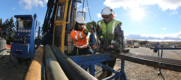
The globally focused mineral scanning technology company says the purchase order is valued at A$170,000 ($127,418) and covers a two-month agreement for the scanning and analysis of circa-2,000 m of NQ core on-site. This work, Orexplore says, will support the current exploration drill campaign activities.

Subject to site conditions and the campaign status, additional core quantities may be added to the scanning program to be determined by Wiluna.

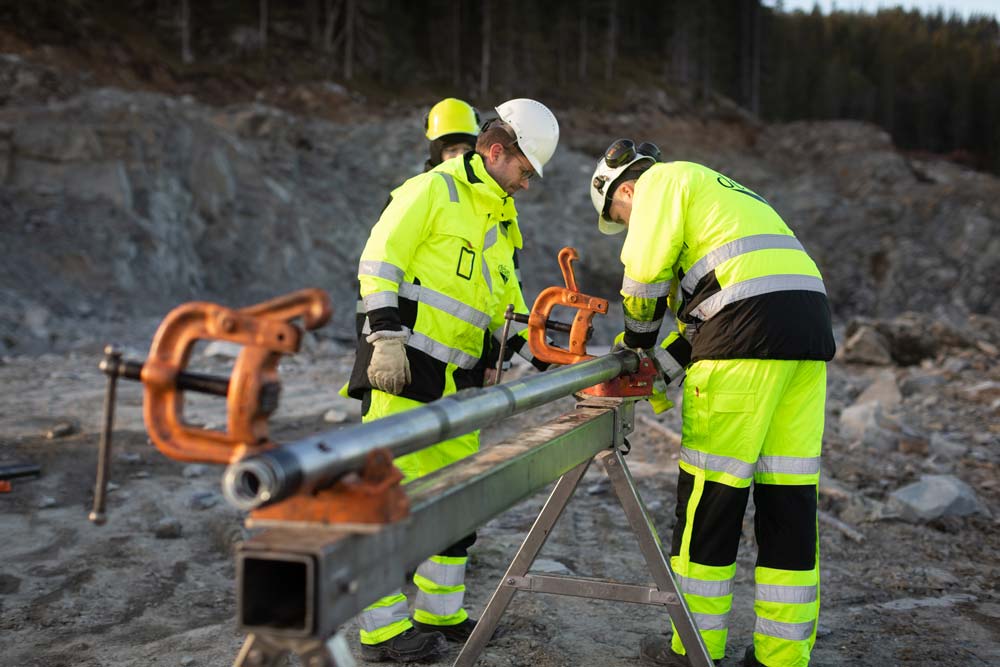
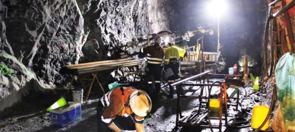
Orexplore will deploy to site a self-sustained containerised unit using the in-field GeoCore X10® platform and the Orexplore Insight analysis software. The company will also deploy to site a scanning technician to operate the unit and effectively integrate it into the site workflows.

The significance of the agreement is that it represents a fully commercial site deployment of Orexplore’s exploration value proposition that delivers improved rapid decision making from near-real-time field-based core analysis that seeks to deliver time and cost savings across exploration programs, Orexplore said.

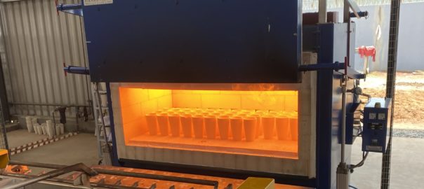
Orexplore’s technology platform comprises its field sensing GeoCore X10 product that extracts information from drilled core potentially hours after its extraction. GeoCore X10 is the result of over 20 years of X-ray research, algorithm development and sensor technology, offering non-destructive measurements and no drill core preparation ahead of time.

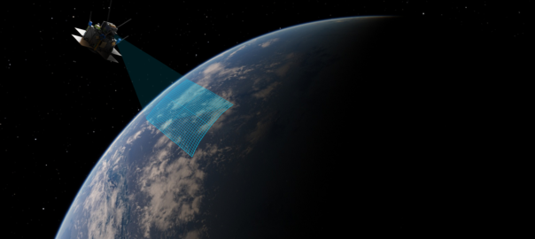
The Orexplore Insight software then connects geological decision makers anywhere in the world to analyse and interpret results to accelerate decision making, the company said.

Orexplore’s Managing Director, Brett Giroud, said: “We are extremely pleased to collaborate with Wiluna Mining as they leverage technology to increase exploration value. This agreement further confirms the increasing demand for operators to receive fast, in-field information from drilling that is fit for purpose and highly targeted towards improving dynamic exploration decision speed and quality.”

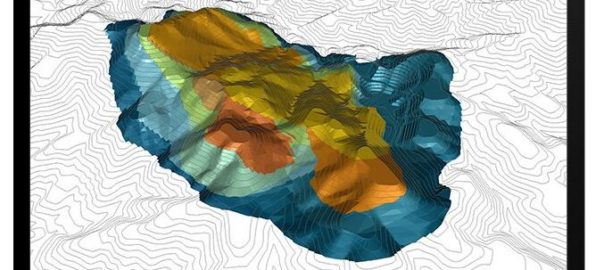
He added: “The in-field deployment of the patented GeoCoreX10 technology that combines high resolution 3D tomography with a large range of detected elements is a unique combination for the mining sector. The deployment at Wiluna, in conjunction with their exploration drilling, further supports Orexplore’s strategy and vision, and we look forward to delivering value to Wiluna.”

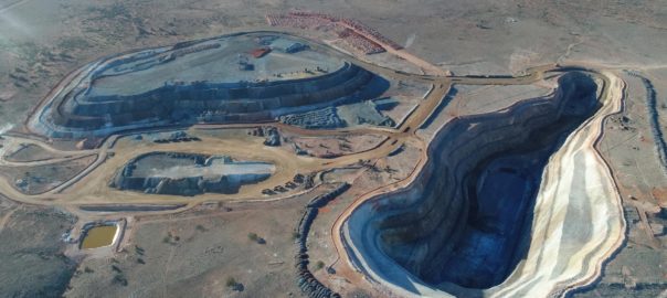
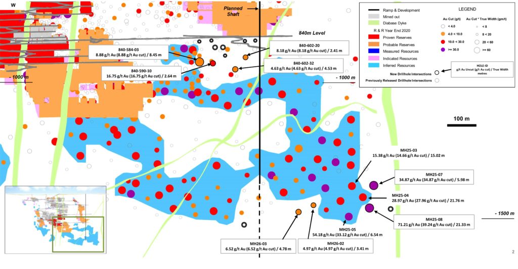
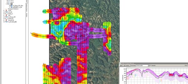
To date, Wiluna Mining has outlined 5.53 Moz of resources and 1.29 Moz of reserves within a 1,600 sq.km tenement package in the Northern Goldfields of Western Australia. The company, last week, said it had produced 3,855 t of gold concentrate since ramp-up (7,800 oz) at an average grade of 69.9 g/t, while three shipments and 4,488 oz of gold had been dispatched.

SGS to support Côte d’Ivoire mining industry with new geochemistry lab

SGS has opened a new geochemistry laboratory in Yamoussoukra, Côte d’Ivoire, as it looks to support a growing local mining industry.

Ivory Coast has huge untapped resources, with estimates that two-thirds of the country is covered in untapped mineral deposits, SGS said. Gold remains one of Ivory Coast’s most valuable mineral resources, with output rising significantly in the previous decade, from 12 t in 2011 to 25 t in 2017 and around 32.5 t in 2019.

To support the country’s growing gold mining industry, SGS has opened a new commercial laboratory in Yamoussoukro. The laboratory, equipped with atomic absorption spectrometry (AAS) and fire assay equipment, provides, SGS says, an extensive range of services related to sample preparation and fire assay analytical testing.

Services include:

  • Au by fire assay with AAS finishing;
  • Au by fire assay with gravimetric finishing;
  • Au by screen fire assay with AAS finishing;
  • Au in carbon by aqua-regia digestion with AAS finishing;
  • Bullion analyses with gravimetric finishing;
  • Other base metals by aqua-regia digestion with AAS finishing;
  • Au in solution by AAS;
  • Specific gravity by gravimetric finishing;
  • Bulk density with paraffin wax by displacement; and
  • Physical tests: pH.

Strategically located in central Ivory Coast, the Yamoussoukro laboratory is close to key mining exploration sites. SGS employees are on hand seven days a week, supporting discoveries for greenfield as well as brownfield projects by providing full fire assay analyses with quick turnaround times, the company said.

Aurelien Nguessan, Laboratory Manager, said: “SGS can now offer mining exploration companies in Ivory Coast complete support, going above and beyond our existing sample preparation capabilities. It’s an exciting time for the industry – and for the country as a whole.”

This new laboratory will complement the services already offered by SGS’ commercial geochemistry labs in the region, including those in Tarkwa (Ghana), Bamako (Mali) and Ouagadougou (Burkina Faso).

Hexagon’s Mining division looks to simplify drill hole data collection with MinePlan GeoSlate

Hexagon’s Mining division has announced the introduction of HxGN MinePlan GeoSlate, a mobile, geological drill hole logging application that, it says, simplifies the field data collection process.

GeoSlate, part of MinePlan’s Exploration Geo package, collects field drill hole data via a recommended field-ready mobile tablet. It integrates with MinePlan 3D, completing the geology workflow from exploration through resource estimation, the company said.

“Built for optimal performance and designed for the field geologist’s workflow, GeoSlate saves time by eliminating the hassle of configuring logging templates from scratch,” Hexagon’s Mining division said. “GeoSlate solves many of the challenges facing geologists who are tasked with geological, exploration, production, sampling, geotechnical, hydrogeological and other field data collection and data management needs.”

Data can be instantly published over Wi-Fi using Hexagon’s microservice architecture, syncing directly to connected MinePlan drill hole databases for subsequent geologic analysis and workflow execution. Instead of spending time exporting/importing, collating and transmitting data, customers can use Hexagon technology to securely store and transfer data from the field to the centralized database at the click of a button, the company claims.

“Access to data should take minutes, but often takes days, even months,” Derek Badner, Product Manager, Hexagon’s Mining division, said. “As part of the integrated MinePlan portfolio, GeoSlate minimises time to data. When connected to Wi-Fi, data can be published from the app and synced in seconds to any authenticated MinePlan Drillhole Manager solution around the globe.

“Valuable time wasted performing data reformatting and quality assurance is minimized using the app’s automatic data validation in the field. We believe GeoSlate will quickly become essential for any mine’s data collection and management needs.”

Di-Corp looks to make inroads in West Africa exploration market with new rep

Di-Corp, a Canada-based manufacturer and distributor of down-hole consumables for the mineral exploration industry, has announced a dedicated West Africa sales representative located in Accra, Ghana.

The Di-Corp Accra representative will support existing and new customers in the region by providing an in-region contact who can coordinate the delivery of high-quality drill rod, diamond tooling, core retrieval equipment, and drilling fluids, the company said.

“As mineral exploration increases across the region, mine operators and drilling companies are looking for every opportunity to improve the efficiency and productivity of their core drilling operations,” Di-Corp’s West Africa Sales Manager, Robert LaFontaine (pictured), said. “Drillers Edge drill rod by Di-Corp has been gaining a global reputation for quality, resilience and longer drill string life even under the most difficult conditions. In fact, all our products are quality assured and field tested for performance.

“As companies look to replace mineral production with new sources of key metals, we’re here to help address the growing demand for drilling supplies.”

While establishing the company’s presence in Accra, LaFontaine will be backed by a remote team that includes technical salespeople, drilling experts, engineers and drilling fluids program specialists.

Headquartered in Edmonton, Alberta, Di-Corp has manufacturing, distribution and service locations in four Canadian provinces, the US, Mexico and now Ghana. Di-Corp also has an international supply chain, plus a total of nine international distributors serving South America, Europe and Central Asia, the Middle East, and Australia.

Rio Tinto partners with Pixxel to investigate hyperspectral satellite tech capabilities

Pixxel, an edge earth-imaging technology company, has announced an early adoption partnership with Rio Tinto spanning mineral exploration, active and closed mine site monitoring and ESG metrics.

Pixxel’s imaging satellites, capable of 5 m hyperspectral imaging, will help Rio Tinto assess the benefits the technology may provide in these areas, the company said. Rio will begin its assessment of the technology following the release of imagery from Pixxel’s first high-resolution satellite, set to launch early this year.

This partnership, Pixxel says, validates the potential benefits that its technology may provide to the resources sector.

“Pixxel’s high-resolution hyperspectral satellite imagery has the potential to significantly reduce costs and timelines for exploration and improve monitoring of active and closed mine sites,” the company said. “In the coming months, Pixxel plans to launch a high resolution hyperspectral satellite, which will capture 50x information compared to common multispectral satellites. Rio Tinto will be assessing the potential of Pixxel’s hyperspectral imagery to help reduce the disturbance footprint of exploration activities, monitor the operational and environmental performance of active mining operations, and monitor biodiversity and vegetation health around closed sites.”

Pixxel Co-Founder and CEO, Awais Ahmed, said: “This partnership will be pioneering in its deployment of hyperspectral satellite imagery for commercial mining operations. We’re excited to be partnering with Rio Tinto to explore the use of hyperspectral remote sensing technology across their operations at a global scale.

“Moreover, the exponential leap in image quality (50x more detail than existing multispectral satellite imagery) allows Rio Tinto the ability to assess Pixxel’s imagery for monitoring critical mining operations and make key decisions with sustainability in mind.”

Dave Andrews, Head of Exploration at Rio Tinto, added: “Rio Tinto is participating in Pixxel’s Early Adopter Program because we believe that exploration could benefit from more cost-effective and easier access to hyperspectral satellite data.”

New IMDEX rig count shows strong growth in major mining regions

New mineral exploration rig use figures released by IMDEX have revealed strong growth in major mining regions across the globe.

The rig use snapshot, which account for seasonal factors, were contained in an IMDEX presentation to the Macquarie WA Forum on December 2. They were taken in October and updated a similar assessment conducted by IMDEX earlier this year.

The figures, of surface and underground coring and RC rigs, show the fleet is close to capacity in Australia and New Zealand at 81%, up from 72% in April.

European rig use in October was 50%, up from 39%, South America 48% (39%), Africa 57% (54%), Canada 65% (46%), Mexico and Central America 48% (44%).

Globally, rig use increased from 46% in April to 55% in October.

The USA, at 64%, was down from 72% but North America was up from 49% to 59% utilisation.

IMDEX Chief Executive Officer, Paul House, said delivery times for new rigs had increased, and the sector was facing skilled labour shortages and mobility restrictions — but these were short-term constraints.

“We’re seeing recovery and growth in all key IMDEX regions,” he said. “This is flowing through to revenue, and is reflected in increasing demand for IMDEX HUB IQ™ connected sensors and software as companies continue to embrace innovation and new digital ways of working.”

House said there was continuing strong demand for gold, copper and other base metals, but that demand for critical minerals was expected to increase at a faster rate because of the push for decarbonisation.

The profile of exploration spending is shifting, through a combination of targeting, compliance, and drilling at depth, he added.

House said the company’s recent acquisition of Mineportal and investment in Datarock had added strength to IMDEX’s geoscience analytics, artificial intelligence, and computer visualisation capabilities as part of its integrated rock knowledge expertise.

“IMDEX technologies enable us to provide critical insights right through the mining value chain,” he said. “Our global presence is unrivalled and provides a compelling opportunity to embed real value for clients.”

South Australia Government extends Accelerated Discovery Initiative

The South Australia Government says it will extend its Accelerated Discovery Initiative (ADI) until 2025, committing another A$11.5 million ($8.2 million) to the program.

The ADI provides co-financing to mineral exploration activities to attract greater exploration investment, bringing forward new mineral resource discoveries, jobs, Aboriginal employment opportunities and royalties, according to the government. It also has a focus on supporting innovative technologies, collaboration and new exploration concepts to fast-track mineral exploration across South Australia.

Minister Dan van Holst Pellekaan said the ADI plays an important role in maintaining South Australia’s international leadership in mineral exploration development.

“We expect to receive a high level of interest during round three, with a funding of up to A$3 million reflecting the global significance of ADI and the calibre of proposals,” van Holst Pellekaan said. “ADI is Australia’s most diverse exploration co-funding program, offering support for traditional drilling and geophysics, as well as other non-conventional exploration techniques, frontier logistics support, technology and research innovation.

“With a heavy emphasis on new technologies, scientific endeavour, and upskilling, to boost discovery while reducing risk, ADI reflects the changing drivers in exploration.

“Successful projects will bolster activities and support innovative technologies to generate and test new exploration ideas and increase new data sets to help accelerate data sharing between entities within the exploration sector.

“In additional to innovative exploration programs, ADI initiatives have fostered meaningful employment and upskilling of Aboriginal employees and businesses. So far, during rounds one and two, funding of A$7.4 million was allocated to 36 initiatives.”

Managing Director and Chief Executive Officer of Barton Gold, Alexander Scanlon, said the ADI has allowed Barton to accelerate its innovation-driven exploration approach to the central Gawler Craton region of South Australia.

“ADI facilitated a trial of deep ground penetrating radar (GPR) in the region and early results are compelling,” Scanlon said. “The technique has not only found over 25 shallow new structures, but also their orientation, giving us clear, shallow targets for precise, high-efficiency and low-cost drill testing.

“We are looking at an order of magnitude gain in cost and time to target delineation, acquiring these targets for less than $200,000 over a 1-2 month period, versus A$2-3 million of drilling over a 1-2 year period of time,” he said.

Barton is an ASX-listed gold exploration company with a total attributable circa-1.1 Moz of gold in the resource category (28.74 Mt at 1.2 g/t Au), a pipeline of advanced exploration projects and brownfield mines, and 100% ownership of the only regional gold mill in the central Gawler Craton of South Australia, the company says.

van Holst Pellekaan said Barton’s recent success is another example of the benefits of the ADI not only delivering results for Barton but sharing the results publicly that will help other explorers unlock new discoveries.

“It was pleasing to see round two heavily over-subscribed, with a total of 76 high quality applications received with 22 projects assessed against the project criteria to receive funding,” he said. “We are anticipating a similar amount of interest for round three.”

The extension of the ADI will significantly contribute to increased exploration activity and discovery of new mineral resources to achieve the South Australian Growth State target of A$300 million in annual exploration investment, the government says.

Drilling innovation directs Alamos to golden goods at Island

John A McCluskey, President and CEO of Alamos Gold, tends to look forward, not back, when talking about strategic decisions the Toronto- and New York-listed miner has made during his 18 years heading up the company.

When discussing the acquisition of Richmont Mines, which included the flagship Island Gold Mine asset in Ontario, he allows himself a brief rumination on the market’s first impressions of the deal: “We acquired the asset for around $620 million in November of 2017. The consensus view in the market was we had overpaid for the asset.”

That consensus view considered 1.8 Moz of mineral reserves and resources and production around the 100,000 oz/y mark, among other factors.

“In less than three years, we had Island over the 4 Moz reserve and resource threshold – we’re now nearer to 5 Moz – and the consensus valuation for the asset from analysts covering us is around $1.4 billion.”

That new valuation factors in a production rise – the company is anticipating gold output of 130,000-145,000 oz this year – and long-term growth prospects for the asset. The latter is evidenced by an Island Phase Three Expansion study published last year that envisaged a 2,000 t/d operation (currently 1,200 t/d) able to produce 236,000 oz/y starting in 2025.

While McCluskey says the company was aware of these growth prospects back in November 2017, most market observers will be surprised they have been proven up so quickly after the Richmont Mines transaction.

They probably underestimated what the use of surface directional drilling could do at Island.

Originally leveraged by Richmont Mines’ Chief Geologist and now Island Gold Chief Geologist, Raynald Vincent, back in 2015, the exploration technique has allowed Alamos to successfully step out from and infill holes Richmont and predecessors previously drilled.

Scott R.G. Parsons, VP of Exploration for Alamos, says surface directional drilling, in combination with the exploration team’s understanding on the controls on gold mineralisation at Island and Alamos’ financial backing for exploration, has helped the company grow the asset rapidly.

“The significant resource and reserve growth at Island in the last three years – adding 3 Moz net of 500,000 of mining depletion – was largely driven by surface directional drilling,” he told IM. “We could not have moved the asset forward in such a significant way without it.”

The use of what Parsons says are “standard” surface drill rigs and Devico’s DeviDrill™ steerable wireline core barrels are allowing the company to hit mineralisation far below the mine’s existing underground infrastructure. The DeviDrill tool can make multiple branches from a pilot hole, dramatically reducing both the time spent and the cost of drilling when compared with standard core drilling methods. At the same time, no time is lost on moving the drill rig between branch holes, as the core barrel can be steered from surface to complete the optimal drill patterns.

The DeviDrill tool can make multiple branches from a pilot hole, dramatically reducing both the time spent and the cost of drilling when compared with standard core drilling methods (photo: Devico)

The company has drilled 240 surface directional drill holes at Island for about 200,000 m of drilling using only 27 drill sites, Parsons explained.

“Using conventional surface drilling, the 240 holes would have required significantly more drill sites,” he said.

This would have involved moving the rig more frequently, making the process that much slower and expensive.

Instead, thanks to this directional drilling technique, the company is sitting on an additional 3 Moz of gold resources and reserves garnered in the last three years. This has come with a discovery cost of just $11/oz.

Accuracy, as Devico indicated, is another benefit of this technology.

“Surface directional drilling is not only more effective than standard drilling practices, but we can hit our targets with 1% accuracy,” Parsons added. “So, if we’re drilling a 1,500 m hole, we can typically intersect our target within 15 m from plan, 1,500 m downhole. This predictable drilling spacing is critical for defining a mineral resource with the appropriate confidence level.

“You’d never be able to do that with standard surface drilling.”

This technique is not a silver exploration bullet, though. According to Parsons, it does not work everywhere.

“It really all hinges around the quality of the orebody and our understanding of the deposit and the controls and the mineralisation,” he said. “Knowing we require a certain drill spacing to be able to define inferred mineral resources, we strategically target the down-plunge extensions of the ore shoots.”

At Island, these ore shoots – which are the high-grade portions of the deposit – are laterally extensive in the lateral and vertical sense, Parsons explained.

“With the surface directional drilling, we are able to specifically target these down-plunge extensions,” he said. “With one or two pilot holes and branch patterns, we can evaluate a large area down-plunge and along strike of the existing mineral reserves and resources. In some cases, other gold deposits can have ore shoots that are less predictable, or are not as extensive, so it would be a challenge to apply surface directional drilling without having a strong understanding of the controls of these shoots for targeting.”

And, it should not be forgotten, it requires an investment in exploration that goes beyond simply reserve and resource replacement on an annual basis. Richmont, a much smaller company, was unable to bankroll such a strategy.

Alamos has made a commitment to do this, as evidenced in the 16-year mine life outlined in the Island Phase III study and the $25 million it intends to invest in exploration this year.

The use of surface directional drilling looks set to continue paying off beyond this study, with the company recently drilling its best-ever hole to date by leveraging the technique.

Drill hole MH25-08 – 71.21 g/t Au (39.24 g/t cut) over 21.33 m – in addition to MH25-04 (28.97 g/t Au (26.89 g/t cut) over 21.76 m) have true widths approximately four times greater than the average width of the large high-grade inferred resource block defined up-plunge of them (photo: Alamos Gold)

Drill hole MH25-08 – 71.21 g/t Au (39.24 g/t cut) over 21.33 m – is the hole in question. This hole, in addition to the previously reported MH25-04 (28.97 g/t Au (26.89 g/t cut) over 21.76 m), have true widths approximately four times greater than the average width of the large high-grade inferred resource block defined up-plunge of them. This, the company said, demonstrates the zone has widened in this area, providing even further potential beyond the company’s current growth plans.

“That one – MH25-08 – is the best drill hole ever drilled at Island,” Parsons said. “And that is after 1.3 million metres of drilling and over 7,000 drill holes dating back nearly 100-years.

“That speaks to the potential of this deposit to continue to grow through exploration, and also highlights the prospectivity of the Michipicoten Greenstone Belt.”

More to come

With 27,500 m of surface directional drilling scheduled for 2021 – and only 6,683 m carried out as of May 31 – more of these high-grade intercepts could soon come to the fore.

And Parsons says the company can continue to use surface directional drilling some 500 m below where it is currently drilling down to at Island.

On top of that, the company, having established the necessary underground exploration infrastructure, is equipping its underground drill rigs at Island for directional drilling, with 24,000 m of underground directional drilling planned this year (3,233 m completed as of the end of May).

“This is allowing us to reduce our cost per metre compared with surface directional drilling and allowing us to drill more targets in a shorter amount of time,” Parsons said. “We will continue applying directional drilling technology as long as the orebody is continuing at depth to drill off those ore shoots.”

At Young-Davidson, the company’s other core asset in Ontario, Canada, the company is also making plans to use underground directional drilling.

“One of our plans going into 2022 is to evaluate opportunities to utilise directional drilling from underground exploration drifts established in lower and mid mines at Young-Davidson to target mineralisation down-plunge at depth,” Parsons said.

More broadly, Parsons thinks the company’s exploration team can leverage their understanding of the technology at other assets.

“For us, it is a competitive advantage,” he said. “With a solid geological understanding of the deposit you are looking at and an understanding of the application and the benefits of directional drilling, we can recognise opportunities of what could be occurring at depth where others might not see potential until well into the future after underground infrastructure is established at depth.”

There are obvious cost, time and accuracy benefits to using directional drilling, yet there is another benefit that may get lost along the way.

Without the need to constantly move the surface drill rigs between drill pads, the footprint of these rigs is reduced.

McCluskey says the technology has brought another ESG advantage to Island too.

By being able to quickly drill off more targets and convert these into the resource base, Alamos has been able to think long term with its Island Gold Phase III Expansion and justify the expense of a shaft and paste backfill plant.

This comes with a 35% reduction in emissions compared with using the mine’s existing ramp and diesel-powered truck haulage, he said, explaining that much of the Ontario grid is powered by renewable hydroelectricity.

“This technology has given us the exploration success that has been converted into scale and allowed us to think longer term and afford the infrastructure to make it a ‘greener’ operation,” he said.

With such a long list of benefits, more companies will be looking at directional drilling to prolong the life of their assets and make long-term decisions that make economic and sustainable sense.

Bentley’s Seequent gets geophysical with Aarhus GeoSoftware buy

Bentley Systems’ newly acquired business unit, Seequent, has added Danish company Aarhus GeoSoftware, a developer of geophysical software, to its portfolio.

The acquisition extends Seequent’s solutions for operational ground water management, and for sustainability projects involving exploration, contaminants, and infrastructure resilience, Bentley said.

Aarhus GeoSoftware, a spinoff company from Aarhus University in Denmark, develops the software packages AGS Workbench, SPIA, Res2DInv, and Res3DInv for the processing, inversion, and visualisation of geophysical data from ground-based and airborne electromagnetic, electrical resistivity tomography remote sensing, and other sources. AGS software enables users to create 2D and 3D images of subsurface electrical resistivity, according to Bentley, with the outputs used to distinguish and differentiate subsurface materials. They can subsequently be modelled in Seequent’s Leapfrog to aid in various subsurface investigations.

The software uses electric field measurements, collected at ground level or with airborne sensors, to map the subsurface distribution of certain materials such as water, mineral deposits and clays.

Electrical resistivity, Bentley says, allows a better understanding of the distribution of these materials and, when the water contains other compounds such as salt, researchers and industry professionals can infer the distribution.

The genesis of AGS software was to ensure clean drinking water for future generations by mapping groundwater across Denmark. It is now used in many different areas, including investigating orebodies and waste rock and tailing processes in mining.

Seequent says it will continue its tradition of collaborating with universities and research organisations worldwide through ongoing engagement with Aarhus University for the development of AGS geophysical solutions.

Graham Grant, Chief Executive Officer of Seequent, said, “The acquisition will add new geophysical data processing capabilities to our workflows to help advance subsurface investigation and modelling. AGS software, coupled with Seequent’s advanced geologic modelling and analysis software, creates a key tool in helping understand and manage groundwater and assessing risk in infrastructure such as dams and canals. We’re excited about the new possibilities this opens up for our collective users worldwide, improving life-time digital twins.”

Toke Højbjerg Søltoft, Chief Executive Officer of Aarhus GeoSoftware, said: “Seequent’s global reach will allow AGS software to positively impact more projects worldwide. As we continue to develop solutions, our users will benefit from our tools being in Seequent’s ecosystem and workflow. We’re excited to join Seequent and to work together on our shared vision of helping organisations make more informed and sustainable decisions through a better understanding of the subsurface.”

Drill rig utilisation nears capacity in key mining hubs, IMDEX survey reveals

A snapshot of mineral exploration drill rig use in major mining regions globally has revealed Australia, USA and parts of South America are nearing capacity, as the surge in exploration continues unabated, IMDEX reports.

In a market update ahead of a presentation to the Macquarie Emerging Leaders Conference, IMDEX said rig utilisation in Australia was “nearing capacity” at 79%, and 72% in North America.

IMDEX Chief Executive Officer Paul House said the company was able to produce the snapshot because of its global presence in major mining regions, adding that global rig utilisation had only just returned to or exceeded pre-COVID 19 levels.

The March snapshot showed rig utilisation was at 37% in Europe, 38% in South America, 30% in Africa, and 55% in Canada.

Activity in Canada would be significantly higher in the northern summer drilling season, House explained, while certain parts of South America were at high capacity percentages.

In regions nearing capacity, delivery times for new rigs had increased and labour shortages were adding to the pressure, according to the survey.

“We believe the industry is willing to invest and spend but may not be able to move as fast as it would like,” House said. “The industry drivers of depleted reserves, strong commodity pricing and the trend towards decarbonisation, are driving substantially increased industry exploration budgets.

“However, delivery against these targets will require time and investment in labour, drilling rigs, and other supply chain pressures that are a current constraint.”

He added: “When S+P says exploration will grow by 15-20% in a year and we see that the areas that are most active are running at maximum rig utilisation, and we know the lead time for new rig orders has blown out to nine or 10 months, we believe that increase won’t happen in that timeframe.

“A lack of rigs places even more importance on using the best technology to drill more metres with the rigs that are available.”

House said the long-term outlook for mining technology was strong.

IMDEX was positioned to benefit from increasing demand for digital operations and real-time orebody knowledge, with a strong core business and strategy to outperform industry growth, he said.