Generally, taking a closer look at integrating geological and geophysical data, “exploration is becoming harder,” MiraGeoscience explains, “with greater focus at depth or under cover. Decisions need to be made to eliminate ambiguity and decrease uncertainty within 3D models, supported and cross-validated by multiple data sets. An integrated interpretation is not a simple approach, but provides answers to geoscientific questions which are stronger than interpreting individual data sets on their own. In terms of integrating geological and geophysical data, the essential goal is to interpret the available geophysical data in terms of the geometry and properties of geological domains. Better models underpin better business decisions.”
The integrated process requires a common sense approach to interpretation that is flexible, adaptive and objective driven. It is not an exact formula or workflow; particularly when multiple geophysical surveys are involved. Understanding the relationships between geology, geophysical responses and rock properties is the key to success. First, you must identify how geophysical signatures relate to geology to develop a geological basis for your integrated interpretation. Following this, rapid 3D geological modelling and geologically-based geophysical forward modelling and inversion are essential for model validation and quantitative integration of data.
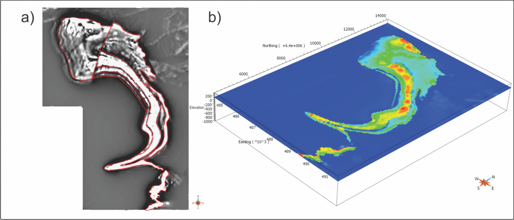
The Mutooroo iron project area, in Australia, is a good example of developing a geologically-based magnetic model using a variety of interpretation, modelling and inversion techniques. Due to limited constraining data on the magnetic units, construction of the starting model was based predominantly on interpretation of magnetic data. In this instance, the goal was to first develop a geologically plausible 3D representation of homogeneous magnetic domains beneath non-magnetic cover that explains the majority of the measured magnetic response. This was supported by the sparse geological data and magnetic susceptibility provided by drilling under cover. The robustness of the magnetic domains are validated by assigning a homogeneous susceptibility to each domain, forward modelling and observing a good correlation between the predicted and measured magnetic data. A final stage of inversion, to solve local susceptibility variations within the domains, highlights magnetic anomalies that may be associated with potential targets or areas of geological complexity that require further investigation. This model, consistent with geological constraints and geophysical survey data, provides a basis for confident decision-making, and can easily accommodate new and evolving information as it becomes available.
The Mutooroo image shows:
- a) Magnetic domain boundaries interpreted from magnetic data. The domains were incorporated in the starting model as sub-crop of magnetic units at the base of cover/oxidation level.
- b) Final susceptibility model at 120m RL (~300 m depth). Integrity of geological domains after inversion validates the developed geological framework and highlights local variations within the domains.
© 2011 Minotaur Exploration Ltd. All rights reserved


