


Surveying and mapping of underground mines can be a challenging and dangerous task. In many cases, it simply isn’t possible to map certain areas because of access issues. Mapping of stopes is one example. While emptying a stope, it is beneficial to map it for volumetric calculations. The designed shape can be compared to the actual shape to assess for over blasting leading to dilution, or under blasting.
Traditional cavity monitoring systems (CMS) surveying of stopeshave limitations because of the reach of the CMS boom along with it being a manual process. In many cases, the CMS will only partially map the stope because of shadowing. The point density is limited and varies depending on the distance from the scanner. These systems also require surveyors to enter hazardous areas near the stope entrance.
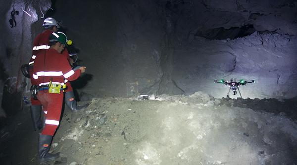
To overcome these issues, the CSIRO Data61 Robotics Group, a Mining3 member and partner, is developing a drone which can autonomously (without pilot operation) fly in and out of stopes and other inaccessible areas. This capability is achieved using LiDAR-based 3D simultaneous localisation and mapping (SLAM) in real time to allow navigation without GPS, and it enables the creation of 3D point clouds. The LiDAR data is used to detect objects within a radius of the drone in all directions, which can then take autonomous collision avoidance actions.
As the drone explores the stope, it generates a map with complete coverage and no shadowing. Beyond basic volumetrics, the resulting point density is very high resolution, enabling identification of geological features and other complex information from the rich data set.
With support from South32, Hovermap has been trialled at Cannington mine in Queensland in January 2017 and more recently in July 2017. Mining3 provided the funding to help demonstrate the Hovermap capability in a mining context. The second trial delivered the world’s first autonomous drone flight in an underground mine. At a trial in Northern Star Resources’ Jundee mine in September 2017, this was extended to the world’s first autonomous, beyond the line-of-sight, flight underground. All of which are major milestones in demonstrating the new technology. Data61 is in the process of commercialising Hovermap and it is envisaged the new technology will be available commercially in the second quarter of 2018.