


A gold mine located in Sessa, Switzerland, was operated from 1858 until 1952. During the last years of its activity (1950-52) up to 500 kg of gold were extracted, which translates into revenues of 2 million Swiss Francs. However, despite the high concentration of gold and silver, the total cost of extraction by traditional excavation techniques, did not offer sufficient revenues to guarantee optimal economic management. The mine was therefore closed and until now has remained inaccessible to the public.
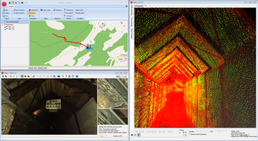
Valerio Marini, Customer Service & Support – Mobile Mapping, Leica Geosystems has reviewed an innovative current project to survey the mine using new technology. “Recently the local community secured funds to recover the mine to protect and preserve it as an point of history and culture in the region. Surveyors have mapped the mine shaft to explore its more than 2,000 m of galleries on four floors while discovering a new flooded well. The part of the mine that currently concerns the surveyors is 400 m long with a main tunnel of 346 m. The galleries will be recovered, keeping their historical uniqueness and will be accessible to the public. The recovery works are divided into the internal and external areas.”
“A group of students of the Master’s degree programme in Geomatics of the Swiss Federal Institute of Technology in Zurich, Switzerland (ETH Zurich) are carrying out an interdisciplinary project were they have surveyed the gold mine in Sessa with different technologies including the Leica Pegasus: Backpack. The students will compare the methods and present a report with the results in January.”
The advantages of the Pegasus:Backpack for this project compared to other survey methods:
- Fast acquisition of the data – 15 minutes for total data capture outside and inside the mine
- Fast processing of the data – 45 min for LiDAR RGB point cloud delivery, plus 90 min with panorama images
- No shadow zones
- LiDAR data with intensity and RGB information
- Direct georeferentiation of the capture – the GNSS antenna allows users to process the data directly in absolute or local coordinate system
- Images – the pictures are essential in this environment for analysis and extraction of valuable information for logistics and safety reasons (eg status of pipes, cables)
All the LiDAR data collected with the Pegasus:Backpack will be used for the creation of the 3D model which will be used to:
- Map the tunnel for tourist information and to market it as a tourist attraction
- Map and analyse the mining shaft for safety reasons
- Create a virtual 3D “fly through” navigation experience
- Generate a 3D printed scaled model for museum exposure
All the LiDAR data collected with the Pegasus: Backpack will be used for the creation of the 3D model which will be used to:
- Map the tunnel for tourist information and to market it as a tourist attraction
- Map and analyse the mining shaft for safety reasons
- Create a virtual 3D “fly through” navigation experience
- Generate a 3D printed scaled model for museum exposure