

Seequent has today released Target for ArcGIS Pro to bring advanced understanding of mining and exploration data to the powerful next generation Esri ArcGIS Pro environment.
The Esri-integrated solution simplifies the importing, viewing and analysis of drill hole and subsurface geological data within ArcGIS Pro to allow geoscientists, geologists and GIS analysts to make timely decisions on project viability and enable faster discoveries, according to Seequent.
The release builds on Seequent’s Target for ArcGIS platform, a geology mapping extension for Esri ArcGIS that simplifies the “visualisation and analysis of drill hole and borehole geology data within ArcMap”.
Seequent’s GM Mining & Minerals, Nick Fogarty, says: “We’ve worked very closely with Esri to create essential workflows for geoscientists in mining and exploration who want to use their data in ArcGIS Pro.
“Our partnership ensures we can deliver interoperability that allows our customers to get the full benefit from both Target and ArcGIS geoscience workflows, creating a world-leading end-to-end solution. Target for ArcGIS Pro is the latest in our ongoing effort to enhance integration and empower advanced geoscience analysis within Esri’s established GIS platform.”
Esri’s Director – Industry Solutions, Natural Resources Sector, Geoff Wade, said: “Seequent is a valued gold level partner of Esri and we are thrilled to see the latest realisation of their product vision for Target.
“The new Target for ArcGIS Pro provides users with additional capability and flexibility, in seamlessly integrating with tools from the Esri platform that many are already familiar with. We are confident this will further improve the efficiency of many geoscience workflows and empower new levels of understanding and insights for our valued joint customers.”
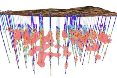
Target for ArcGIS Pro, Seequent says, allows users to import, visualise and interpret drilling data from standard industry data sources or generic formats; view drill hole data by numeric or categorical attributes in 2D maps and 3D scenes; create cross sections to view and interpret your geology in 3D; incorporate subsurface datasets to your project for increased understanding and geological context; navigate the subsurface quickly and easily using 3D navigation shortcuts; and share and collaborate using Esri’s online workflows.