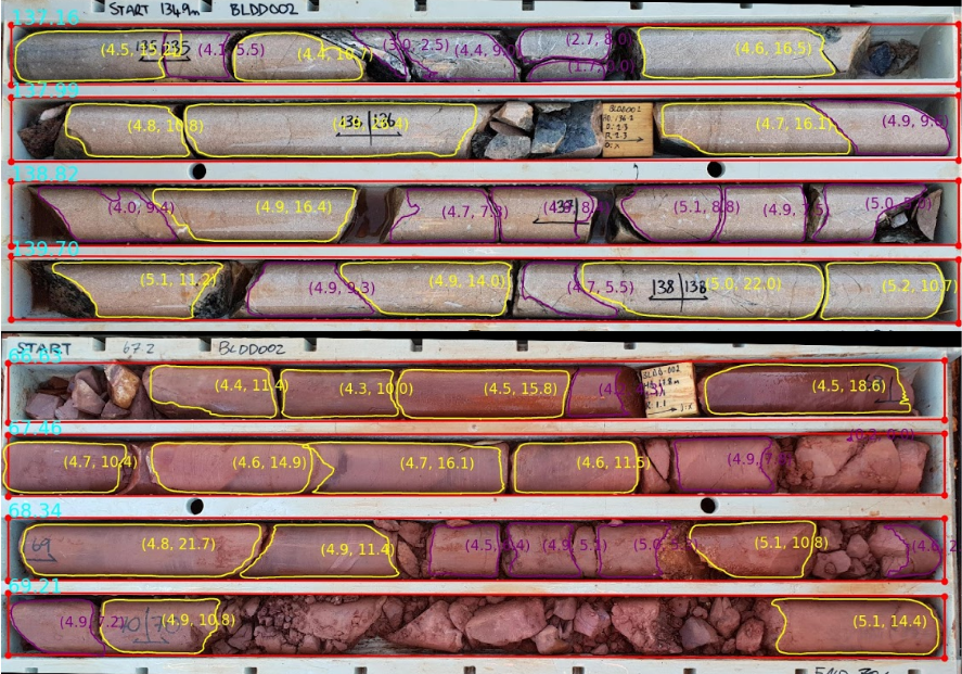
DiUS and Solve Geosolutions have leveraged PyTorch-based image analysis techniques to help automate the analysis of drill core imagery and provide greater insight that can be used to influence decision making on mine sites.
Mine sites often produce between 100 and 1,000 m of drill core per day, generating hundreds of images a week at a single drill site, according to PyTorch, an open source machine learning platform.
Historically, these images have been kept as a record of the job and a resource for geologists to refer to, rather than being used as a quantitative dataset that adds value to a mining operation.
Tapping into this rarely used data source of drill core imagery, DiUS – an Australia-based technology services organisation with a strong focus on machine learning and deep learning image segmentation analysis – joined forces with Solve Geosolutions – a mining-focused data science and machine learning consultancy – to build a machine learning-powered, cloud-based platform to automate the analysis of this drill core imagery using image segmentation technology.
Together, DiUS and Solve Geosolutions worked on applying a range of PyTorch-based image analysis techniques, including image classification, object detection and both semantic and instance segmentation, to a range of geological problems.
In particular, the team wanted to understand how different models performed in terms of training and inference speed, training requirements and overall accuracy of prediction to inform how they could be deployed in a production environment.
One model they used extensively is Mask R-CNN.
“This model can be applied to a range of segmentation tasks, however it can also demand large training datasets that are sometimes not available,” PyTorch said. “To support this, the team developed novel ways to increase the initial, often sparse training dataset through data augmentation techniques such as rotation, flipping, contrast, saturation, lighting and cropping.”
Following the initial discovery period, the team set about combining techniques to create an image processing workflow for drill core imagery. This involved developing a series of deep learning models that could process raw images into a structured format and segment the important geological information, according to PyTorch.
Their first productionised process was a metric referred to as RQD, otherwise known as rock quality designation. “RQD is a difficult and monotonous dataset to collect manually,” PyTorch said. “It’s also well suited to automation, and of high value to a mining operation. RQD is used by engineers to understand the strength of a rock and is used in the design and engineering of a mine.”
With the release of Detectron2 – a PyTorch-based computer vision library released by Facebook in October 2019 – the team made the decision to switch from the previous model implementation on TensorFlow to the next-generation platform to help improve instance segmentation tasks, PyTorch said.
The team found Detectron2 to be four times faster in training the models (using GPUs) and three times faster in inference (using CPUs) than the previous model implementation, PyTorch said.
Building the models on PyTorch-based frameworks meant the team was able to reduce valuable training time across the board. This increased the number of experiments and, as a consequence, improved model accuracy on an identical dataset. The PyTorch Dynamic Graph also made it much easier for the team to debug and investigate any issues that arose, PyTorch said.
The resultant Datarock platform is a software as a service offering that applies machine learning – image segmentation technologies – to drill core imagery and delivers information about a mineral deposit’s geology at scale, and at a resolution that’s not been previously economically viable, PyTorch says.
Since launching Datarock in 2019, the team has extended the platform to turn drill core imagery into high-quality datasets to support decision making throughout the entire mining cycle.
“The models perform optical character recognition, instance and semantic segmentation, as well as geological statistical analysis on a dataset,” PyTorch said. “This allows a geologist to inspect the model prediction and check for quantity and quality in unmatched datasets.”
Mining and exploration companies can now get consistent geological information from their rock core imagery in a matter of minutes, according to PyTorch.
“This near real-time power is enabling more intelligent decisions to be made further down the mining chain – saving time and money that can be put towards other business-critical projects – and freeing up geologists to do higher value tasks,” PyTorch said.
To date, the Datarock platform has processed more than 1 million metres of drill core images – that’s enough core to cover the distance between Sydney and Melbourne – over 800 km.


