


The University of Queensland and research partners Plotlogic Pty Ltd have developed new automated mining technology that, they say, will facilitate automation of the mining process while improving operating efficiency.
The research has shown how artificial intelligence can use scans of the mine face to almost instantly identify valuable minerals and waste rock, allowing each stage of the mining process to be planned more effectively in advance, UQ said.
Professor Ross McAree, Head of School of Mechanical and Mining Engineering from UQ, said the new technology used visible and infrared light to automatically classify materials.
“Each mineral has its own characteristic response to different wavelengths of light, so by scanning the mine face with our system we can map out the minerals present in the rock and their concentration (ore grade) almost instantaneously,” Professor McAree said.
This real-time mapping allows the mining process to be planned out before digging even starts, according to the researchers.
“Beyond this immediate efficiency gain, the enhanced ability to recognise ore grade could also underpin future autonomous mine systems,” Professor McAree said. “Machines equipped with this imaging system would be able to recognise ore grade as they were excavating it. Linked to artificial intelligence, this could allow automated machinery to operate in the mine environment, removing workers from hazardous parts of the mining process.”
Real-time ore grade classification at the mine face could also enhance mine scheduling and improve resource recovery and minimise processing waste, the researchers claim.
The project was supported by the Minerals Research Institute of Western Australia (MRIWA), with MRIWA CEO, Nicole Roocke, saying investment into research like this helped position Australia’s minerals industry at the leading edge of technology development.
“This imaging approach could prove particularly valuable where rapid extraction and consistency of ore grades could provide a competitive advantage to those leading the way,” Roocke said.
The project, which was conducted in 2018-2019, had a total grant value of A$850,850 ($653,322). In addition to MRIWA, UQ and Plotlogic, CITIC Pacific Mining and AngloGold Ashanti were also involved, hosting trials at the Sino iron ore and Tropicana gold mines, in Western Australia, respectively.
It was based off the OreSense® prototype system, developed to meet the needs of the research project, as well as offering a commercial pathway for early industry adoption of the technology.
“The prototype delivers a system capable of acquiring, processing and classifying hyperspectral data in the field and in real time, mapped to terrain and geo-referenced for integration with mine maps,” the project partners said. “In order to be the most general and applicable to all minerals, the hyperspectral imaging capabilities cover the visible to short wave infrared spectrum (400-2,500 nm).
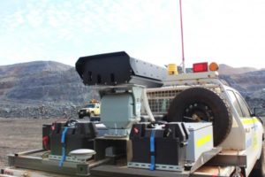
“The surveying capabilities of the system rotate in more than one axis to perform face scans and build a 3D data-cube from two individual line-scanning hyperspectral sensors. The system spatially and spectrally fuses the data cubes from the two sensors to provide a single data-cube for an entire scene. The system also performs on-board corrections and post-processing of the hyperspectral data to support real-time ore grade classification.”
The prototype used on site during the trials consisted of a sensor head with LiDAR and hyperspectral cameras, a pan-tilt unit and a GNSS receiver among other elements (see photo above).