Emesent and Datamine have announced a partnership, enabling geotechnical structure mapping through Hovermap and Sirovision to further assist mining companies.
Datamine has partnered with Emesent to further assist mining companies to gain new insights from previously inaccessible areas by enabling geotechnical structure mapping through Hovermap and Sirovision. A move that both CEO’s agree is a win-win for them and their customers. Emesent’s ambition to help mining customers boost productivity and improve outputs has led to this partnership with Datamine.
“Emesent’s Hovermap technology is the most innovative solution in the industry for collecting detailed information from inaccessible areas, providing a valuable new data source for mapping and analysis,” says Dylan Webb, CEO of Datamine.
“We’re excited to be working with Datamine to unlock new insights for our mining customers,” says Emesent CEO and Co Founder Dr Stefan Hrabar. “This partnership helps us move closer to our vision of a digitally-driven mining ecosystem.”
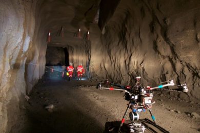
Emesent, is a world-leader in drone autonomy, LiDAR mapping, and data analytics. Emesent was founded on over ten years of CSIRO research. It has built a reputation for enabling autonomous data capture in the mining, infrastructure, and survey and mapping industries. Its award-winning, flagship product, Hovermap, is a smart mobile scanning unit. Hovermap provides advanced drone autonomy to map hazardous and GPS-denied environments.
Datamine is one of the world’s leading providers of technology that allows seamless planning and managing of mining operations. It provides solutions spanning resource modelling, mine planning, operations, and logistics worldwide including its open pit and underground mining software, Sirovision, for geological and geotechnical mapping and analysis. Like Hovermap, Sirovision also originated from many years of research at CSIRO.
The Emesent and Datamine partnership has ensured the seamless import of Hovermap scans into Sirovision, where users can then identify and map geotechnical structures in the scans. The complete range of geotechnical analysis tools, from wedge detection to slope stability, allows valuable insights to be extracted. Emesent’s Hovermap allows data to be captured from previously inaccessible areas. This includes beyond-visual-line-of-sight and in GPS-denied environments such as stopes, ore passes and raises. This provides mining companies access to valuable insights about geotechnical features that weren’t previously possible.
“Hovermap is a fast and safe way to capture 3D data underground for structural mapping. It’s a great addition to our solutions that will allow customers to capture more data than ever before. It’s a great addition to our solutions that will allow customers to capture more data than ever before,” said Esa Immonen, VP Customer Experience at Datamine
Together Emesent and Datamine say they will be optimising the integration of their products to provide powerful and efficient end-to-end workflows for their customers.