


Sandvik Mining and Rock Solutions and Exyn Technologies have furthered their strategic partnership looking at new horizons of mine autonomy with the introduction of the Sandvik Exyn inspection concept.
An autonomous mapping solution that can co-operate with autonomous machines without stopping production, according to Jussi Puura, Research and Technology Development, Digitalization Lead at Sandvik Mining and Rock Solutions, the pair launched the concept at MINExpo 2021, in Las Vegas, today.
The integration, the pair said, allows mining customers to benefit from comprehensive underground aerial 3D mapping with visualisation that increases overall transparency of mining operations – including for GPS-denied, hard-to-reach, or hazardous areas, or locations that would be time-consuming to survey and inspect using conventional methods.
Exyn and Sandvik deployed this integrated solution at gold exploration and development company Rupert Resources’ Pahtavaara project in Finland, using the ExynAero drone to autonomously create a 3D point cloud of an underground stope. This 3D data was then uploaded to Sandvik’s OptiMine Mine Visualizer and georeferenced to the CAD mine model for further analysis and visualisation.
The companies said back then that it planned to further develop the partnership to integrate more hardware and software systems, and they have now done just that, premiering the new concept at this week’s MINExpo.
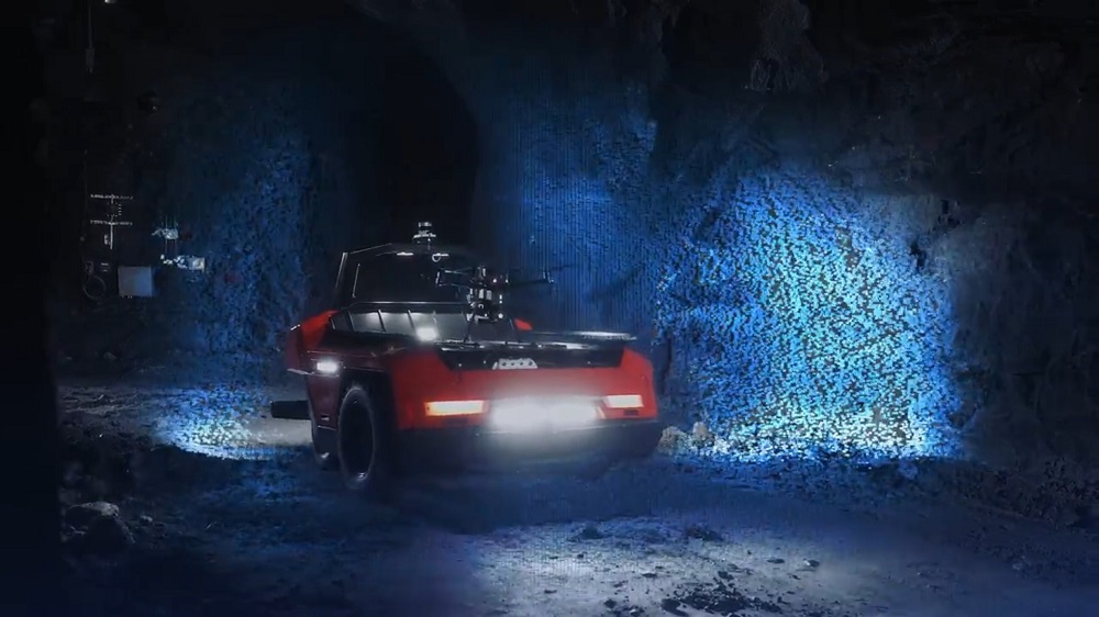
The concept works by an operator indicating the area they want surveyed on the OptiMine 3D visual screens, and then ordering that survey. The ground-based machine then starts the assigned mission at a time that is convenient and does not cause any production interruptions.
After deployment and when the wheeled inspection vehicle cannot drive any further, the on-board autonomous UAV is deployed to complete the survey of the area of interest.
When the survey mission is complete, the UAV lands on the ground-based robot and both return to the charging station to await the next mission. The data from both vehicles is then automatically uploaded to the Sandvik Data Management Server, part of the OptiMine suite.
The server processes all data automatically and georeferences it to existing data in the server, using the survey team’s data as ‘anchors’ and ‘ground rules’ for the new data. The data is automatically merged into an updated model of the mine.
In addition to merging and ‘cleaning’ the data, the system can be set up to run automated analysis on the data. For example, automatic reports on change detection, shrinkage detection, road condition, etc can be run after every survey.
The solution results in better planning, increased safety and less production stops, according to the companies.