


Exyn Technologies, a pioneer in multi-platform robotic autonomy for complex, GPS-denied environments, has announced a partnership with Stitch3D, a provider of modern cloud solutions, to host, manage, view, process and share point cloud data securely directly on the web.
This collaboration helps to expand the impact and accessibility of portable SLAM capture devices by allowing feature rich point cloud data to be broadly shared and acted upon, Exyn says.
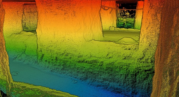
The Exyn Nexys is a completely modular 3D mapping solution designed to reduce time to capture, increase safety and drive efficiency in challenging, complex, or dangerous environments like mining, logistics, construction and infrastructure inspection. Through this partnership, Exyn and Stitch3D unlock the potential of 3D data with user-friendly software that simplifies the navigation and management of point clouds across various industries, according to Exyn.
This strategic collaboration is designed to expand the reach of Exyn’s transformative mapping technology by making it accessible to more customers through Stitch3D’s innovative point cloud management and collaboration software. After uploading a feature-rich Nexys data set into Stitch3D, operators will be able to perform volumetric calculations, generate digital elevation models, automatically classify ground points, or annotate areas of interest for project management – all in real-time with multiple stakeholders operating simultaneously, the company explained.
“At Exyn, we are dedicated to delivering solutions that allow more industries to easily take advantage of SLAM-based LiDAR scanning technology to increase safety and drive efficiency across a variety of active working environments,” Brandon Torres Declet, CEO of Exyn Technologies, said. “We are thrilled to partner with Stitch3D to make the analysis, management and sharing of high-quality 3D models equally streamlined.”
Clark Yuan, founder and CEO of Stitch3D, said: “Stitch3D is committed to bringing LIDAR solutions to the web through our collaborative cloud architecture and automated point cloud processing software. The partnership with Exyn will enable users to capture a high quality point cloud, rapidly calculate stockpile volumes, generate DEMs, or classify ground points – all in a real-time multiplayer 3D viewer. We are very excited for this partnership to deliver quality point cloud intelligence at the tactical point of need.”