Tag Archives: geoscience

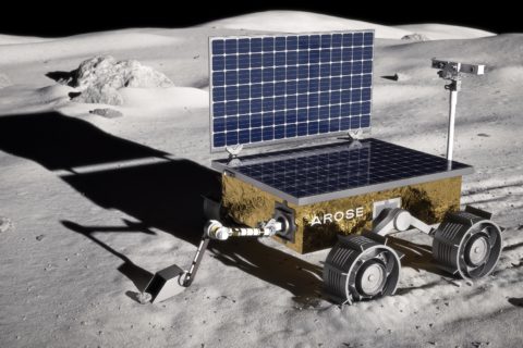
Mining and space sectors collaborate to solve the biggest challenges

A quiet revolution is underway in the mining sector as innovations and knowledge gleaned from space exploration help improve productivity, reduce emissions and create better outcomes for workers and communities, AROSE* Program Director, Michelle Keegan, explains.

The extreme demands of Space exploration and the drive for efficiency in the mining industry is creating new forms of cross-sector collaboration not seen before. The transfer of expertise and technology between these two sectors is also delivering solutions to some of humanity’s greatest challenges.

There are many commonalities between modern resource businesses and space exploration. Both require a focus on a smaller footprint, the delivery of zero-carbon emission operations and a reliance on substantial amounts of data to support decision making. They both operate in sensitive and challenging geographic environments and need to work in a way that reduces risks to their employees and the environments in which they operate.

The space industry provides a rich learning platform for the resources sector, for new approaches to increasingly difficult challenges. But the benefits of collaboration are not all one way. The space sector too is benefitting from the technological innovations and experience of miners here on Earth.

Technology developments in exploration precision, resource planning, advanced mineral detection sensors, in-situ extraction methodologies and advanced safety systems, present opportunities for insights and application in space.

Deep thinking around regulatory frameworks for responsible and sustainable space exploration and development will be enhanced through the experiences, both positive and negative, in terrestrial resource development.

Diversity of thinking

The opportunity to transfer technology and drive diversity of thinking from the space sector into mining will accelerate in the years ahead. Global demand for the critical minerals required to meet the world’s ambitious decarbonisation goals illustrates the need to leapfrog current approaches across the mining project lifecycle, from exploration through to production.

Rio Tinto CEO, Jakob Stausholm, recently described the global mining giant as a “technology company”.¹ In saying this he recognises Rio’s success in tackling the big challenges will rely on the miner’s ability to integrate new technologies and novel approaches to problem solving.

In a world where mining is becoming more complex, more difficult and more expensive, the ability to reduce costs (and emissions) and win the support of governments and local communities will rely on the ability to deploy technology to mine and process ore more efficiently and more safely, both for people and the environment.

Many post-carbon technologies, such as solar energy and battery storage systems, have been advanced through space exploration. Also, it is the systems engineering approach to project design, pioneered for space exploration, that increasingly is being adopted by terrestrial resources, technology and services companies.

Australia’s leading mining and oil and gas operators, as well as their major service companies, are aligning themselves with space-focussed businesses, researchers and industry organisations because they recognise the value of cross-sector collaboration. This new collaboration model is leading to greater technology and expertise transfer between space and resources. Miners also recognise the benefits of their best people being exposed to new knowledge and new ways of problem solving.

Trailblazer Lunar Rover project

The AROSE consortium was created for exactly this type of collaboration – to drive the growth of Australia’s space industry and bring together companies from resources and other industries, to leverage their collective capabilities and go after the toughest challenges in new ways. The Trailblazer Lunar Rover project is a first significant focal point for our space capable businesses and like-minded resources companies to pursue shared technology opportunities.

The AROSE Resources Advisory Board, established in 2022, creates an ongoing opportunity for the most innovative mining company leaders to provide input into the rover project, while taking learnings back to their businesses at the same time.

NASA understands well the benefits of this type of collaboration. Earlier this year AROSE participated in the first of a series of workshops with NASA and the United States Geological Service to look specifically at the areas of intersect between the resources and space sectors.

The mining industry is at a turning point in its decarbonisation journey. It has a once-in-a-generation opportunity to build new capabilities that will lay the foundations for long-term, sustainably driven growth. With an aggressive timeline to zero emissions, a great opportunity for the mining industry to solve this tough challenge is the successful building of relationships with uncommon partners like those in the space sector.

However, a broader partnership opportunity exists between mining and space. The domains we see as offering the best collaboration opportunities between space and mining include:

  • Automation and robotics;
  • Remote operations and control;
  • Geoscience;
  • Satellite communications and imagery;
  • Artificial intelligence;
  • Systems engineering;
  • Waste minimisation;
  • Digital design, including user experience and user interface; and
  • Data analytics.

It is evident space and mining projects are approached very differently. The design of a resources project is most typically achieved by bringing together the experiences of past projects, with a focus on budget and schedule. Operating concept or operating philosophy often takes second priority and does not drive the project design. As a result, an integrated systems design is never achieved. And while available technology enables some level of electrification, automation and digital decision making, the value that could be derived is never fully realised.

Andrew Dempster, Director at Australian Centre for Space Engineering Research at the University of NSW, says, “the high-level difference between the approaches of the two industries is that the mining (and oil and gas) decision points are all and always commercial, whereas the agency-driven space projects have more technical ‘system engineering’ decision criteria.”²

Dempster states “a fundamental observation about the difference between mining engineering and the space engineering disciplines (electrical, electronic, software, mechanical) is that the latter designs a product…while the former designs a business. It appears this is the fundamental disconnect”.

For many years the mining industry value chain has been unchallenged. Valuable resources are mined, processed then moved to a distribution point via rail or road and then shipped to a customer. However, there are several collaboration opportunities that could lead to mining companies rethinking value chain design, and these opportunities have the potential to alter the mining flowchart.

Perhaps the ideal approach we can use in mining is an integration of both approaches, and in this way adopt systems engineering thinking at the outset.

AI and data analytics

With an increasing need to build in automation, sensing and electrification, underpinned by digital platforms, the concept of operations needs an integrated approach more than ever. The growth in the application of AI and data analytics techniques to quickly interpret geological and physical properties of rock in mining has been exponential. As data streams become more complex and decision pressures more acute the demand for more sophisticated approaches to AI will only increase.

The space industry has had an even greater need to manage and interpret a plethora of complex data in real time to support mission critical decisions and there are obvious crossover opportunities to be explored in this arena.

With the hunt underway to locate resources on the moon or other planets to extend human life into outer space, the opportunity exists for mining technology companies to assist with rock knowledge acquisition and mineralogical interpretation of data required for successful space exploration.

Robotics and automation

The application of robotics and automation is expanding in the resources sector with the drive to remove people from harm and increase efficiency and precision in the mining process. Mining technology company IMDEX was motivated to partner with AROSE as a way of bringing space insights to the development of its BLAST DOG technology (pictured below), an automated logging system that collects detailed geoscience data from blast holes.

Major challenges IMDEX faced during the BLAST DOG development phase included: autonomous navigation over rough terrain; locating and positioning accurately over a blast hole; lowering and retrieving a sensitive, high-tech probe down the hole; and managing the transfer of high volumes of data through remote communication systems. IMDEX is refining its approach based on insights gleaned from companies involved in addressing these same challenges in space.

The recent affiliate agreement between AROSE and the Robotics Australia Group will increase this application across the industry.

Autonomous vehicles

In mining, the scale of operation has been linear until recently. If you wanted to increase mining output, you purchased more large equipment. Then came the introduction of fleet automation technologies, developed first by Caterpillar in 1996 and refined in partnership with Rio Tinto and other early adopters in the early 2000s.

Of the 1.5 million vehicles in use across heavy industry globally, only 1,200 vehicles are autonomous.³ Australia has the largest fleet of autonomous haul trucks in the world, with more than 700 in operation across 25 mines.4 Clearly the market potential is enormous.

These remotely operated technologies are challenging the need for ever larger truck sizes. The largest autonomous truck today might be the last of its kind as mining organisations consider what the ‘right size’ truck is for the future.

Smaller size trucks would allow miners to fully electrify their operations much sooner. In addition to the environmental benefits, there are operational and cost benefits that support this approach. The large autonomous trucks currently in use need enormous bi-directional roads. Reducing the size of mining vehicles can have a direct impact on strip ratios, and with a mine that can be up to 1 km deep, the roads that service the mine contribute significantly to the overall footprint.

While every mine design is different, there is a growing body of evidence that smaller autonomous vehicles can lower mine development costs (narrower benches, steeper pits, etc), speed operations and boost overall fleet utilisation.

The space industry has similar challenges with its autonomous vehicles. Where the mining industry is an expert at moving billions of tonnes of material by operating hundreds of autonomous vehicles all year round, the space industry today has only operated 11 semi-autonomous vehicles on a planetary body. This observation isn’t to diminish the significant achievement, as space exploration is extremely difficult, but to highlight the convergence of terrestrial and space objectives. For the space industry to perform in-situ resource utilisation activities anywhere off-earth, there is an opportunity to adopt learnings from the mining industry.

Likewise, the mining industry is moving towards smaller more specific/targeted mining practices and can learn from space industry experience in developing small-scale highly efficient and robust robotic solutions.

The space industry also provides a rich learning platform for the resources sector for new approaches to minimise and utilise the waste stream, with the ultimate goal of zero waste mining operations.

The companies which provide technology and services to the mining majors also realise they need to diversify their offering to include space. This ‘full stack’ approach may be a matter of business survival in a competitive future.

Remote operations specialist Fugro is a leader in this area. Fugro’s new SpAARC (Space Automation, Artificial Intelligence and Robotics Control) remote operations centre in Perth, Western Australia, has been specifically designed to share facilities between its established oil and gas and mining business and its fledgling space offering.

Fugro’s new SpAARC remote operations centre in Perth, Western Australia, has been specifically designed to share facilities between its established oil and gas and mining business and its fledgling space offering

Fugro and Nova Systems are leading the AROSE consortium’s Trailblazer Lunar Rover design team. Woodside Energy and Rio Tinto are also supporting the AROSE Trailblazer effort by providing knowledge transfer of their terrestrial robotic and automation capabilities.

Woodside has also formed a collaboration with NASA on robotics and remote operations. NASA sees Woodside as a great test bed of robotics in harsh environments, as Woodside is doing similar tasks at its operations which NASA envisages doing on the Moon and Mars.5

The largest challenges facing the mining industry are the need to get to zero emissions, the need to get to zero harm and zero waste. There’s urgency in the call to solve all of these. It is now well-recognised that we need more collaboration not just within our sector, but across sectors. With the Moon to Mars program now underway, and the Trailblazer Lunar Rover program in place, this really is a tangible point in time where things are moving forward, a tangible point where people realise that this isn’t a dream, this is a reality.

* AROSE (Australian Remote Operations for Space and Earth) is an industry-led not-for-profit organisation dedicated to ensuring Australia is the trusted leader in Remote Operations science, technology and services on Earth and in Space.


Sources:
1. ‘Solving our largest on earth challenges through the benefit of technology transfer between space and mining,’ Michelle Keegan, Gavin Gillett, Clytie Dangar, World Mining Congress 2023.

References
1. ‘We’re a tech company’: Rio boss draws on lessons of history, Australian Financial Review, 2 August 2023. https://www.afr.com/chanticleer/we-re-a-tech-company-rio-boss-draws-on-lessons-of-history-20230801-p5dt2p
2. Integrating the approaches to space and mining project life cycles, Andrew Dempster, 5th International Future Mining Conference 2021. https://www.ausimm.com/publications/conference-proceedings/fifth-international-future-mining-conference-2021/integrating-the-approaches-to-space-and-mining-project-life-cycles/
3. No swarming yet in trillion-dollar market, Investmets, 4 August 2023. https://www.investmets.com/no-swarming-yet-in-trillion-dollar-market/
4. Global autonomous mining truck population tops thousand mark, to reach 1,800 by 2025, Mining.com, 18 May 2022. https://www.mining.com/global-autonomous-mining-truck-population-tops-thousand-mark-to-reach-1800-by-2025-report/
5. https://cciwa.com/business-toolbox/growth/why-woodsides-partnership-with-nasa-is-a-win-win/

SensOre expands AI-based geophysics capacity with Intrepid Geophysics acquistion

SensOre Ltd says it has reached an agreement to acquire Intrepid Geophysics, a provider of geophysics software and services headquartered in Melbourne, Australia.

The deal, valued at around A$5 million ($3.4 million) will be primarily funded through the issue of new fully paid ordinary SensOre shares.

Intrepid Geophysics’ advanced automated geophysical software and geoscience expertise complement SensOre’s existing suite of machine learning and artificial intelligence-based mineral exploration software products and technology offerings, it said, adding that Intrepid Geophysics’ large client base and strong cashflows were integral to its strategic assessment of the transaction.

SensOre Chief Executive Officer, Richard Taylor, said: “Acquiring Intrepid Geophysics is a major opportunity for us. Intrepid Geophysics’ deep geoscience and machine-learning expertise in geophysics complements SensOre’s geochemistry and economic geology focus for targeting in mineral exploration. Demand for advanced geophysics software is strong and deployable globally.

“Intrepid Geophysics’ years of product leadership, data collation and collaboration with government geological surveys will benefit SensOre’s data platform development and client service offerings. We are looking forward to integrating Intrepid Geophysics’ exceptional talent with our team of innovators.”

Intrepid Geophysics Managing Director, Dr Desmond Fitzgerald, added: “The combination of SensOre and Intrepid Geophysics will unlock growth opportunities in a strong market for high-level exploration targeting. We look forward to being part of a growing and exciting geoscience group.”

SensOre and Intrepid Geophysics completed a successful pilot project in Victoria in the June quarter, confirming the technological synergies and product complementarity between the two companies, it said. The results of the pilot are expected to be deployed with clients in the September quarter, focused on the Stawell and Ballarat gold corridors. There is strong interest from prospective clients within these corridors, according to SensOre.

SensOre says its strategy has been to organise all of Australia’s geoscience data within its proprietary data cube technology, with the acquisition of Intrepid Geophysics significantly advancing that capability.

The deal also expands SensOre’s mineral exploration technology sector presence and exposure, with the deal seeing the company acquire a second team of dedicated geoscience professionals with cross-over expertise in the oil and gas, groundwater, geothermal and the emerging hydrogen storage sectors.

“In acquiring Intrepid Geophysics, SensOre gains access to multiple new targeting and decision-based proprietary technologies and strategic decision-based services using 2.5 dimension Airborne Electro-Magnetic inversion technology, tensor gradient technology, geology from geophysics feature extraction, and service automated workflows,” the company added.

These technologies, SensOre says, fill a gap in its product suite by incorporating geophysics products that take exploration targeting from the macro-focused Prospectivity Modelling and Discriminant Predictive Targeting® approach into drill target delineation in three dimensions.

Intrepid Geophysics’ software portfolio includes:

  • Intrepid 3D – an airborne and ground geophysical data processing and interpretation package;
  • Moksha-EM – an airborne electromagnetic full waveform inversion data processing and interpretation package;
  • Argus – a 3D geological modelling package with a tightly integrated geophysical forward and inverse modelling capability;
  • JetStream II – a web-based, spatially searchable data catalogue that enables geoscientists to quickly assess the coverage, type and vintage of georeferenced spatial data held over any given area; and
  • Sea-g Marine Gravity – a fully featured marine gravity processing application powered by Intrepid Geophysics technology for on-cruise and post-cruise use.

IMDEX bolsters real-time rock knowledge with Datarock investment

IMDEX says it has boosted its rock knowledge capabilities with a deal to acquire an initial 30% stake in image analysis company Datarock for A$5.5 million ($4 million).

Datarock has, IMDEX says, extensive geoscience and data science expertise that has led to the development of a cloud-based platform which applies artificial intelligence and machine learning to automate the extraction of geological and geotechnical information from core imagery, videos, and point clouds. This automation creates high value datasets that drive efficiency within mining operations, IMDEX added.

IMDEX has an exclusive option to acquire the remaining interest in Datarock over the next four years in a two-tranche process, subject to Datarock achieving agreed strategic milestones.

The partnership will enable IMDEX and Datarock to work together to accelerate growth plans, including product development and market expansion, it said.

IMDEX Chief Executive Officer, Paul House, said Datarock’s existing and planned products complemented IMDEX’s existing software including ioGAS™, aiSIRIS, MinePortal, and its cloud-based platform IMDEXHUB-IQ™, and strengthened the company’s ability to deliver real-time rock knowledge answer products.

“The Datarock team and the products they have built are strongly aligned with our strategy, our existing product offering and our value proposition for clients,” House said. “Data collected by geologists and engineers inform operational and financial decisions throughout a mine’s life cycle. This data is commonly collected manually, which is slow, laborious and can be prone to human error. Datarock aims to eliminate this error and deliver high quality and auditable data that provides value for the entire life of the mine.

“We are looking forward to working with the Datarock team. Its members are experts in the field of geoscience, data science and AI, and like IMDEX, have a drive for developing technologies to solve the mining industry’s biggest challenges.”

Datarock is an Australia-based mining technology company servicing the global exploration and mining sector. It is owned by two private companies, Solve Geosolutions Pty Ltd and DiUS Computing Pty Ltd. Solve Geosolutions and Datarock recently combined to both operate under the Datarock name. Solve is one of Australia’s leading geoscience machine learning and data science consulting businesses. DiUS is an Australia-based consultancy that helps organisations build the future using its expertise in AI, machine learning, IoT, cloud computing and product development.

Datarock’s products are applicable across the mining value chain, from geotechnical analysis of drill core during drill out, through to the mining and extraction phase, according to IMDEX. It has an existing customer base with major mining companies globally.

Datarock Chief Executive Officer and Director, Liam Webb, said there were clear synergies between Datarock’s products and several of IMDEX’s offerings.

“By working together, we will add considerable value to both companies,” Webb said. “When we started seeking investment our primary goal was to align ourselves with a company who saw the future the same way we did and could help us achieve our goals. I feel by entering into this agreement with IMDEX, who we believe are one of the world’s leading mining technology companies, we have achieved this.”

Seequent adds to cloud-based geoscience software base with Imago acquisition

Bentley Systems’ Seequent business unit has acquired Imago Inc, a developer of cloud-based software for the capture and management of geoscientific imagery.

The acquisition, which comes only a month after announcing the purchase of Aarhus GeoSoftware, will expand Seequent’s technology solutions portfolio while boosting cloud capabilities to help geoscientists and engineers solve earth, environment and energy challenges, it said.

Imago’s cloud-based platform enables the capture, cataloguing and review of drilling core and chip images from any source, to support every aspect of the geological process from exploration to grade control. Continued development of Imago’s machine learning will lead to a step function in the interpretation of geological data, according to Seequent.

Seequent said: “Mining companies around the world apply Imago’s solution in conjunction with geology data management and modelling tools to enable teams to make more confident, profitable decisions using instantly available, high-quality images. Seequent already integrates its Leapfrog, Oasis montaj, Target, and Minalytix MX Deposit with Imago’s solution, making it easy for geologists, engineers and other stakeholders to extract knowledge and learn from geoscientific imagery. The goal is to unlock significant potential for mining and other industries, transforming image data into meaningful insights for geological activities.”

Imago establishes a consistent process for capturing high-quality images, which integrate with existing workflows and allow the application of machine learning

Graham Grant, CEO of Seequent, said: “It’s an exciting step to welcome the Imago team on board to help advance Seequent’s progression into the cloud. We’re continually exploring ways to provide new technologies and solutions to solve workflow challenges, improve operational efficiency and deliver greater value for our users who are working to solve some of the world’s major civil, environmental, and energy challenges. This acquisition demonstrates Seequent’s continued growth and our commitment to make a positive contribution to the industries we serve globally.”

Imago’s Co-Founder, Federico Arboleda, said: “As a small team in Phoenix and Perth, we’re excited to join forces with Seequent, as this will now allow us to substantially scale Imago’s solutions in mining and other markets. We founded Imago to help mining companies manage the high volume and size of geological images and unlock the great value in this geoscience imagery. Image data is an increasingly important source of data across the geosciences – and can come from potentially any source, including core photos, hyperspectral, aerial photos, drones, and handheld devices. It will become even more important to transform image data into knowledge as automation needs increase.”

Seequent helps miners in COVID-19 era with remote geoscience software tools

Geoscience software company Seequent says it is accelerating the development of its cloud-based solution, Seequent Central, to enable organisations to continue work on critical, large-scale, earth, environment and renewable energy projects in the COVID-19 impacted environment.

Central works alongside Seequent’s other geoscience analysis, modelling and collaborative technologies, to contribute understanding to subsurface geoscience and engineering design solutions.

The cloud-based solution allows people in any location to visualise, track and manage geological models created for infrastructure and critical services projects, in a centralised, auditable environment, according to Seequent.

This means a wide range of stakeholders can readily access highly visual up-to-date information to manage risk and make better environmental and investment decisions, to progress projects, it said.

Seequent CEO, Shaun Maloney, said the company was working alongside customers to do everything it can to make it possible to meet the demands and operational challenges they may be facing in the current environment.

“In response to increased need and demand, we’re accelerating the development of Central to help our customers to continue to operate in interdependent and often remote work environments,” he said.

Seequent’s software is being used on hundreds of diverse projects across the globe, ranging from infrastructure projects including large-scale rail, road and tunnel projects across North America, Europe, and Asia-Pacific; renewable energy projects in the US, Finland, Iceland, Indonesia, Philippines and New Zealand; mining and exploration projects in North and South America, Africa and Australia; and environmental projects such as groundwater management in North America, Europe, Africa and Asia-Pacific.

One of these projects is with Canada-based mining company First Majestic.

Focused on silver production in Mexico, First Majestic currently owns and operates the San Dimas silver-gold mine, the Santa Elena silver-gold mine and the La Encantada silver mine. The company is pursuing the development of its existing mineral property assets with industry practice modelling using Seequent’s solutions, according to the geoscience software company.

“First Majestic use Seequent’s Leapfrog Geo to develop a realistic presentation of the geology at each site (complex silver deposits with multiple veins), and Leapfrog Edge to aid resource estimation – and when geologic models are changed resource estimates also change dynamically,” Seequent says.

“Seequent Central allows the company to publish models and resource estimates – so they are immediately available to everyone from the mine geologists to management in real time.”

First Majestic Resource Geologist, David Rowe, says the company can now capture multiple resources across multiple mines.

“We can now get all cross-discipline experts together to review projects in one place, and I am notified when those reviews have happened,” he said. “This enables better access and collaboration for everyone.”

Australia extends and expands Exploring for the Future geoscience program

Australia’s government has extended Geoscience Australia’s Exploring for the Future (EFTF) program for a further four years in a move that will support a stronger recovery and more regional jobs across the whole country, according to the Minerals Council of Australia.

The program has been highly successful in collecting pre-competitive geophysical data from the north of the country for use by researchers, explorers and mining companies, while attracting new exploration investment and jobs amid growing international competition from emerging mining regions, the MCA said.

The latest move will see the government invest a further A$125 million ($86 million) to expand the program’s reach to cover the whole of Australia, a statement from Minister for Resources, Water and Northern Australia, Keith Pitt, read.

It comes on top of the A$100 million previously spent on the program to drive investment, generate jobs and secure the future of the resources sector, Pitt said.

“The EFTF program uses a series of cutting-edge geoscientific techniques to map the geological structures at unprecedented scale and detail,” the statement read. “This freely available information creates a better understanding of our mineral, energy and groundwater systems and allows us to realise Australia’s economic potential.”

Pitt said even though Australia is known for its world-class mineral resources sector, over 80% of Australia is still underexplored.

“Over the past four years, EFTF has worked across northern Australia to deliver world-leading data about the region’s mineral, energy and water resource potential to industry, government and communities,” he said. “We are confident of the long-term impacts of the existing program, with independent analysis of the first half of the program, indicating it could deliver just over A$2.5 billion in economic benefits and jobs in northern Australia.”

He concluded: “The existing program has already demonstrated significant success unlocking Australia’s resource potential in the north that extending it just made sense. This will give industry, investors and the broader community a consistent, nation-wide picture of our natural resource potential.”

Welcoming the investment, Geoscience Australia Chief Executive, Dr James Johnson, said he looked forward to continuing this fundamental support for the resources sector.

“As the nation’s pre-eminent Earth science organisation, Geoscience Australia integrates the most advanced geoscientific methods and data to build an ever-improving understanding of our mineral, energy and groundwater resources for the benefit of all Australians.

“During the first phase of EFTF, we built on that understanding by releasing 200 datasets through a new online portal and developing innovative tools to help explorers assess the economic viability of a resource and make their next big investment decision. We can now develop this as a national resource.”

Exploration investment is the foundation of Australia’s mining industry, which generates A$289 billion in export revenue, directly and indirectly supports 1.1 million jobs and contributes A$39 billion in royalties and taxes to Australian governments, according to the MCA.