Tag Archives: GPS

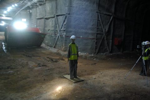
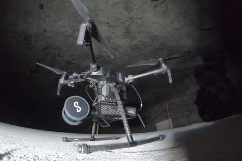
Exyn’s drone-based mining autonomy ambitions taking flight

Having already achieved the highest documented level of aerial autonomy – level 4A – with its drone-based solutions, Exyn Technologies is striving for further industry firsts, Raffi Jabrayan, VP of Business Development and Commercial Sales, says.

One of its more recent breakthroughs came in Germany at the K+S’ Werra mine site, where a team demonstrated the use of the ExynAero™ and ExynPak™ at an underground salt mine.

Over the course of three days underground, Exyn’s field engineers successfully flew multiple autonomous missions in hard-to-reach areas while capturing rich, high-fidelity point clouds in a fraction of the time it would take traditional cavity monitoring systems, according to the company.

Jabrayan explained: “Several drone companies had previously attempted an autonomous mission to scan the immense cavities this specific site has, but the dust interference meant most of these missions ended within seconds.

“We were able to fly in some cavities completely beyond visual line of sight, mapping areas in a fraction of the time the teams would normally take for such manual inspections. In all, we were able to carry out a six-minute autonomous flight at the site.”

While the company did not carry out any specific modifications to its ExynAero platform to conduct such a flight, Jabrayan acknowledged that ongoing design and software improvements over the last year had enabled the company to accurately detect both dust and thin wires underground.

In addition to this, the company also displayed the capabilities of its handheld ExynPak solutions while on site in Germany.

The ExynPak, according to Exyn, can provide the world’s first real-time colourised point cloud visualisation on a handheld LIDAR scanner, capturing precise, colourised 3D models 20-30 times faster than a traditional stationery tripod or terrestrial scanner.

Powered by ExynAI™, the ExynPak ‘drapes’ real-time RGB information captured through two hemispherical fixed cameras onto point clouds created by a gimballed Velodyne LIDAR Puck LITE, providing operators a complete colourised 360° view of their environment, Exyn says.

At the Werra mine site, the Exyn team was able to capture a colourised cloud where the stratification of the rock could be clearly seen in the scan, enabling the K+S team to obtain data it would likely never be able to replicate in any other way, according to the company.

Jabrayan says such information could see operators plan their mining processes around the colourised captures, following mineralisation identified by the scans to ensure no economic ore had been missed after mucking out.

At the Werra mine site, Exyn’s field engineers successfully flew multiple autonomous missions in hard-to-reach areas while capturing rich, high-fidelity point clouds in a fraction of the time it would take traditional cavity monitoring systems


The ExynPak is likely to become a core part of Exyn’s next aerial autonomy offering for open-pit mining, powered by ExynAI, which enables safe flight in the most dangerous industrial environments.

“We have done some work in terms of moving our flights to the surface,” Jabrayan said. “It could cover various aspects – tailings monitoring, highwall scans…there are lots of requirements for it. We are actively working on integrating GPS into our ExynAI stack for outdoor autonomous flights, however, it’s not ready to be pushed to customers just yet.”

The company is currently working on surveys of ground-based resources, such as stockpiles, using a handheld ExynPak, plus carrying out aerial flights in manual mode.

Reaching the level of autonomy it has underground will most likely involve the help of its collaboration partner, EY, and a third company providing “software and visualisation input”, Jabrayan says, adding that he expects to see this autonomous solution come to light in 2023.

Earlier this year, Exyn, in partnership with Maestro Digital Mine, presented an aerial drone fitted with a Maestro gas monitoring Industrial Internet of Things (IIoT) device.

This new gas monitoring drone, which integrates critical gas sensors onto the ExynAero and ExynPak platforms, is effectively the “quickest and safest mobile gas monitor on the planet”, Michael Gribbons, CEO and Co-founder for Maestro, said.

Powered by ExynAI’s multi-sensor fusion capabilities, gas sensor readings are captured while the robot is in flight and displayed in real time via a ruggedised tablet, Exyn explained. These sensor readings are saved with precise coordinates in a high-fidelity point cloud that can be exported and examined in a variety of mining software.

Jabrayan says a lot of mines have reached out to the companies since first presenting the solution at the SME MineXchange Annual Conference & Expo in Salt Lake City, earlier this year.

“They are interested in the benefits such a solution could provide in terms of safety and productivity,” he said. “By flying the gas sensing drone underground soon after a blast, it could take the necessary readings and issue a notice to another system that it is safe to re-enter the area.”

This could see more mines shift away from re-entry processes based on out-of-date manual gas readings, to a system that is much more accurate and shaves – potentially – hours off operational downtime.

Exyn is closing in on a long-term trial agreement with at least one miner in Australia looking to test out this gas-sensing drone solution, according to Jabrayan.

“The long-term plan is to develop a drone-in-a-box solution that can reside underground and be flown immediately after a blast to offer the quickest possible readings,” he said. “Remote autonomous mapping of this type could see Exyn provide data to shift operators as they are heading underground, allowing them to get a picture of the environment ahead of reaching the location.”

The incorporation of such data into mine site operational processes could see drone-based solutions become vital to the running of mines in the future, and Exyn, through its post-processing pipeline, ExSLAM, is looking to enable this.

ExSLAM extracts the raw cloud from robot logs and refines it for third-party software, using a factor graph optimisation algorithm to create low-drift point cloud maps.

Jabrayan says the company continually receives plaudits from customers about the ease of use of this solution, explaining that Exyn is one of the few companies that georeferences its maps inside an existing coordinate frame.

“From there, we are able to detect all the survey points, download them, georeference them and push the data to any end-user software,” he said.

Exyn, Jabrayan says, is software agnostic when it comes to this process, but he did admit the company was in advanced talks with some leading mining software companies that could see its mapping data integrated directly into their platforms.

“We are also working with certain companies to use robotic process automation to make it a one-button process to scan, go directly into the end-user software, and create a mesh that can be used,” he said.

“We remain focused on using our technology and R&D to provide the best solution to customers in order for them to be as productive as possible and, of course, work in a more efficient and safe manner.”

UP’s Vehicle Dynamics Group to boost UG mine safety with new testing facility

An engineering team at the University of Pretoria (UP) has pioneered an underground procedure which tests the performance of collision avoidance systems (CAS) in an effort to improve the safety of workers on mines through reducing unwanted interaction between vehicles and pedestrians.

The Vehicle Dynamics Group (VDG) is a research unit at UP’s Department of Mechanical and Aeronautical Engineering that is actively involved in the South Africa and international mining industry.

It saw a need to develop such a system based on the continued number of fatalities that have occurred as a result of interaction with mining machines and to be in step with subsequent changes (yet to be promulgated) in Chapter 8 of South Africa’s Mine Health and Safety Act (1996) that requires trackless mobile machines to warn the operator if a significant risk of collision exists. If the operator fails to heed the warning, the machine must automatically slow down and stop safely.

“Mining machines are becoming smarter by the day, with smart, connected vehicles promising to be the mining method of the future,” Professor Schalk Els, VDG Researcher, said. “Smart mining machines are now utilising technology such as high-precision GPS and automotive radars to prevent unwanted interaction with other machines, pedestrians and infrastructure.”

Dr Herman Hamersma, also a VDG Researcher, added: “This development is a stepping stone to full autonomy – not only on mines but in urban and highway environments too. Mining machines typically perform repetitive tasks with well-defined mission profiles, which allows for the automation of many of their operations.”

The VDG has aided in the formulation of industry guidelines to analyse and improve the readiness level of collision avoidance offerings on the market, according to UP, and has developed a standard testing procedure to evaluate both surface and underground collision management systems based on guidelines set out by the Minerals Council South Africa.

CAS assessments were previously limited to above-ground testing, with UP saying its involvement has brought about change in the CAS space, having contributed significantly to the increasing maturity of commercial offerings.

“With the VDG’s recent development of an underground testing system, it is anticipated that the technology readiness of current underground CAS offerings will be even more improved,” it said.

The performance of CAS is tested by way of a stage-gate approach. The first stage gate is a lab-scale test conducted on light vehicles in a controlled environment. The CAS is installed on the light vehicles exactly as would be in a mining environment.

Dr Hamersma said: “These vehicles are equipped with brake robots that control the stopping distance and can be controlled to represent minimum brake specifications, while high-precision GPS accurately measures the speeds and positions of the vehicles. An advanced data capturing and control system is used to control the brake robot and to record the GPS data, and the decisions communicated to the test vehicle by the CAS.”

If the CAS passes the lab-scale test, it can proceed to the next stage-gate, where the system is subjected to a single interaction test conducted in an environment that is more representative of a mine. To date, testing has been limited to surface tests due to the reliance on high-precision GPS as the ground truth measurement. However, the VDG team’s recent development of an underground system makes use of LiDAR (which uses laser light to calculate distances), cameras and automotive radar to measure the distance between objects and their speeds.

The system has been tested at a training facility at one of South Africa’s underground mines, and the first live underground single interaction test is in the pipeline. The system will be used to validate the lab-scale results of underground CAS solutions in their intended underground environment where line of sight, dust and uneven, slippery road surfaces are serious concerns.

The international community has noticed the activity in this space in South Africa, and this has led to collaborations with international CAS vendors and industry bodies such as the International Council on Mining & Metals (ICMM), the ISO working group leading the development of the collision avoidance standard and a project in collaboration with Mining3, a research institute based in Australia that was funded by the Australian Coal Association Research Programme (ACARP).

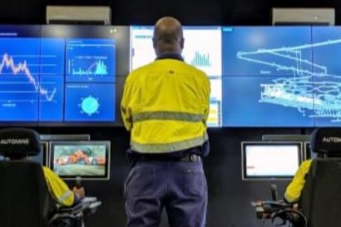
Emesent builds mining connections as Hovermap autonomy takes off

Having recently helped DJI’s M300 drone fly autonomously underground (through its Hovermap Autonomy Level 2 (AL2) solution) and signed an agreement with Deswik to provide surveyors and planners with more accurate data from inaccessible areas, Emesent has been on a roll of late. IM put some questions to CEO, Dr Stefan Hrabar, to find out more.

IM: First off, if no communications infrastructure is in place at an underground mine, how do Emesent’s drones stream a 3D map of the environment back to the operator’s tablet?

SH: Hovermap is smartly designed to operate beyond the communication range of the operator. The operator does not always need to see a live map since Hovermap is navigating by itself. The user can place a waypoint beyond the current limits of the map, and beyond line of sight and communication range. Hovermap self-navigates towards the waypoint, avoiding obstacles and building the map as it goes. Once it reaches the waypoint (or if the waypoint is impossible to reach), it automatically returns back to the operator. The map data is stored onboard Hovermap and when it returns back to within Wi-Fi range the new map data is uploaded to the tablet. The operator can then see the new areas that were mapped and place a new waypoint in or beyond that map, sending the drone back out again to explore further.

IM: What results have you so far received from using AL2 for Hovermap at mine sites? Were the results PYBAR got from trials at Dargues and Woodlawn in line with your expectations?

SH: Last year’s trials at Dargues and Woodlawn showcased some great outcomes for the PYBAR team, including the ability for Hovermap to capture valuable data using Autonomy Level 1 (AL1). The team saw great potential in the technology, leading to the purchase of two systems for their use. Earlier this year, AL2 flights were conducted at Dargues during the final pre-release testing phase. Even the first stope at Dargues that was mapped using AL2 highlighted the benefit of the system over traditional CMS (cavity monitoring systems). A large area of overbreak was identified in the Hovermap scan. The same stope had been mapped with a CMS, but this area was not visible from the CMS scan location so the overbreak was not identified.

A number of mines have been using AL2 to map their stopes and other areas beyond line-of-sight. With AL2, they can send Hovermap into places that previously would have been inaccessible, enabling them to obtain critical data in real time without risking the machine or personnel.

The AL2-based stope scans have been more detailed and complete (lack of shadowing) than ever before. A beyond line-of-sight flight down an ore pass was also conducted recently, with Hovermap guiding the drone down 120 m and returning safely to produce a very detailed scan.

The high level of autonomy provided by AL2 also allows remote operation of the drone. We recently completed a trans-continental demo, with a customer in South Africa operating a drone in Australia using our AL2 technology and standard remote collaboration tools. The remote operator in South Africa was able to use their laptop to experiment with the technology from the other side of the world, sending Hovermap exploring down a tunnel.

This is a taste of what’s to come, with drones underground being operated from the surface or from remote operation centres thousands of kilometers away. This will remove the need for skilled personnel on site, and reduce the time spent underground.

IM: What had been holding you back from achieving AL2 with drones/payloads? Is it the on-board computing power needed to that has been the issue?

SH: Flying underground where there is no GPS, the space is tight and there are hazards such as mesh, wires, dripping water and dust is very challenging. We overcame many of these with AL1, which makes it safe and easy for a pilot to operate the drone within line-of-sight (Hovermap provides collision avoidance, position hold and velocity control). AL1 has been deployed for 18 months with many customers around the world, clocking up thousands of hours of use. This helped to improve the robustness and reliability of the core flight capabilities.

Emesent CEO, Dr Stefan Hrabar

AL2 builds on this mission-proved base capability to provide additional features. AL2 allows the system to fly beyond line-of-sight and beyond commination range. This means it’s on its own with no help from the operator and needs to deal with any situation it comes across. There are many edge cases that need to be considered, addressed and thoroughly tested. A significant amount of effort was put into these areas to ensure Hovermap with AL2 is extremely robust in these challenging environments. For example, the drone downwash can kick up dust, blinding the LiDAR sensor. We’ve implemented a way to deal with this, to bring the drone home safely. Other considerations are returning in a safe and efficient way when the battery is running low, or what to do if waypoints cannot be reached.

IM: How do you anticipate your partnership with Deswik impacting the mine planning and survey process? Do you see this reducing the amount of time needed to carry out this work, as well as potentially cutting the costs associated with it? Have you already carried out work at mine sites that has proven these benefits?

SH: Our commitment is to help mining companies increase safety and production while reducing costs and downtime. We do this by providing surveyors and planners with more accurate data from inaccessible areas, allowing them to derive new insights. Our partnership with Deswik means we’re able to provide a more comprehensive end-to-end solution to the industry.

We see this as a very natural partnership that will improve the overall customer experience. Hovermap excels at capturing rich 3D data in all parts of the mine (whether drone based, hand-held, lowered down a shaft on a cable or vehicle mounted). Once the data is captured and converted to 3D, customers need to visualise and interrogate the data to derive insights. This is where Deswik and other mining software vendors come into play. They have powerful software tools for planning, survey, drill and blast, geotechnical mapping and a host of other applications. We’re partnering with these vendors to ensure seamless integration between Hovermap data and their tools. We’re working with them to build automated workflows to import, geo-reference, clean and trim the data, and convert it into formats that are suitable for various tasks.

Surveyors at Evolution Mining’s Mungari operation have been using this new process in Deswik. Previously they needed a third software tool to perform part of the workflow manually before importing to Dewik.CAD. The intermediate steps have been eliminated and others have been automated, reducing the time from more than 30 minutes per scan to five minutes per scan.

IM: Since really starting to catch on in the mining sector in the last five years, drones have gone from carrying out simple open-pit surveys and surveillance to drill and blasting reconciliation platforms to reconnaissance solutions carrying out some of the riskiest tasks in underground mining. In the next decade, how do you see them further evolving? What new tasks could drones carry out to improve safety, cut costs or increase productivity?

SH: Emesent’s vision is to drive forward the development of ‘Sentient Digital Twins’ of industrial sites to future-proof the world’s major industries, from mining to energy and construction. These industries will be able to move to more automated decision-making using high-quality, autonomously collected data across their sites and tapping into thousands of data points to make split-second decisions about potential dangers, opportunities and efficiencies using a centralised decision-making platform.

We see our Hovermap technology being a key enabler for this future. Drones and other autonomous systems will become an integral part of the mine of the future. Drones will be permanently stationed underground and operated remotely, ready for routine data collection flights or to be deployed as needed after an incident.

Hovermap is already addressing some of the biggest challenges in mining — including safety and operational downtime. It improves critical safety to mines, keeping workers away from hazardous environments while providing better data to inform safety related decisions such as the level of ground support needed. This then feeds into better efficiency by helping mines to more accurately calculate risks and opportunities, aid decision making and predict situations.

Hovermap can significantly reduce downtime after an incident. For example, it was used to assess the level of damage in LKAB’s Kiruna mine after a seismic event. More than 30 scans were captured covering 1.2 km of underground drives that were not safe to access due to fall of ground. In another case, one of our customers saved around A$20 million ($14.6 million) after an incident, as they could use Hovermap to quickly capture the data necessary to make a critical decision.

IM: In terms of R&D, what future payload developments are you investing in currently that may have applications in mining?

SH: We’ll keep adapting our Hovermap design to suit new LiDAR improvements as they are released. More importantly, we’ll improve the autonomy capabilities so that even more challenging areas can be mapped with ease. We’re also adding additional sensors such as cameras, as these provide additional insights not visible in the LiDAR data. Our colourisation solution is an add-on module for Hovermap, which uses GoPro video to add colour to the LiDAR scans. This allows the identification of geological and other features.

Resolute Mining starting to deliver automation benefits at Syama Underground

Resolute Mining, in its 2019 financial year results, said commissioning of the Syama Underground automation system is now well underway following the company reaching commercial production rates in quarter just ended.

The gold mine, in Mali, mined 737,338 t of ore over the period, as the company, in its financial year, moved from development to production in the sub-level cave.

At full capacity the underground mine is expected to produce around 46,000 t/week of ore, or 2.4 Mt/y, using a fully integrated automated mine fleet that is being facilitated through a partnership with Sandvik. Once the underground mine is fully commissioned, Syama will be capable of producing over 300,000 oz/y of gold, according to Resolute.

In the financial results, the company said the automation switch was gradually being turned on, with operators in the newly completed surface control room (pictured) now able to control underground production units over shift-change, blasting and re-entry periods, when there are no personnel in the underground mine.

Resolute said: “This represents the initial delivery of one of the main benefits of automation, the ability to maintain production over periods when operations would normally cease in a typical manual mine.”

The company noted that the fibre optic backbone and mine-wide wireless network was now complete from the portal down to the 1055 haulage level and was connected to the surface control room.

“This network enables the operation of the automated haulage loop, automated rehandle level, mine digitisation and production automation, all of which allow operators to monitor and control mine production in real time,” the company explained.

A major technical characteristic of what Resolute is referring to as “the world’s first fully automated haulage loop” is the ability for Syama’s haul trucks to rapidly transition from laser-based underground navigation to surface-based differential global positioning system (GPS) navigation.

The company said recent trials at Syama demonstrated Resolute’s haul trucks can acquire the feed from the two surface GPS base stations and seamlessly lock onto satellite guidance to complete the transition to GPS navigation without any delay or speed reductions.

The next phase of the company’s automation work will see the commissioning of the 1055 haulage level with automated rehandle loaders and haulage trucks working together to load from an ore pass and truck directly to the surface run of mine pad, Resolute said.

“With the fans, pump stations, control room and communications network complete, the automation project is being progressively handed over to the operations team which is now at normal operational manning levels,” the company concluded.