Tag Archives: IDS GeoRadar

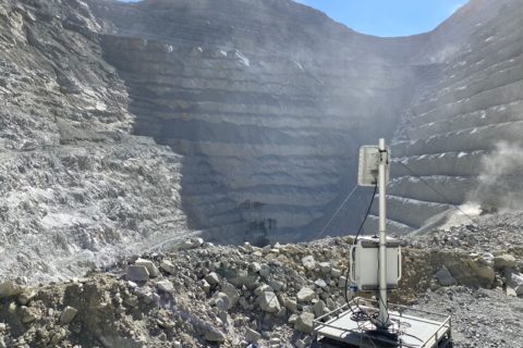
IDS GeoRadar enhances algorithms for Guardian slope monitoring software

IDS GeoRadar, part of Hexagon, has announced the new SMV algorithm for Guardian, its software for slope monitoring.

Developed by IDS GeoRadar’s R&D team together with major players of the mining and monitoring industry, SMV is the result of a two-year collaboration and development, it says.

“Guardian SMV provides a revolutionary approach to radar monitoring as the first algorithm specifically designed for low vegetated assets’ management,” IDS said. “Guardian SMV processes radar data for the early detection and visualisation of very slow deformations in low vegetated environments – typical of tailing dams. The implementation of an innovative velocity estimator extends the sensitivity to impressive low-end velocity ranges, similar to satellite InSAR.”

IDS says Guardian SMV provides a unique reduced noise level with an optimal filtering of the noise caused by low vegetation and drastically reduces the decorrelation effects on radar data.

Guardian SMV performs an efficient and continuous monitoring of low vegetated environments supporting professionals in the early detection of ground instabilities, it added. This sees the solution provide “unprecedent benefits” for continuous monitoring of very slow movements, reducing the negative effects of low vegetation on radar data and providing a reliable detection of displacements in the few mm per month velocity ranges.

IDS GeoRadar widens rockfall radar support with latest RockSpot update

IDS GeoRadar, part of Hexagon, has announced a new software update for RockSpot, its innovative radar system able to locate, track and notify on rockfalls.

RockSpot’s latest software release expands the data analysis performance with new tools supporting an efficient rockfall risk zonation, TARP fine tuning and back analysis to reduce operational and geotechnical risks, according to the company. The new multiple statistical tools allow users to manipulate the events database and plot custom charts based on defined areas and items – such as event rate, duration/area extension, velocity and run out distance of rockfall – for a comprehensive back analysis, models calibration, integrity of rockfall controls and design change justification.

Rockfalls are a major safety threat in open-pit operations. The sudden onset of rockfall events makes it difficult for conventional monitoring methods to provide adequate pre-warning and a comprehensive analysis, resulting in a challenge for mine operators and planners.

RockSpot is, according to IDS, the industry’s first end-to-end solution able to trigger notifications on rockfalls in real time and to maximise rockfall hazard management, providing an explorable rockfall database for back analysis and an automatic classification of falling events.

This compact and powerful radar picks up falling rocks in near to real time and working crews receive prompt notification for action along with immediate access to all event’s details that are tracked, stored and classified in a rockfall events database.

IDS concluded: “RockSpot provides 24/7 continuous monitoring night and day to actively support in sync risk management with real-time notifications and improves risk mitigation and planning operations with multiple statistical tools to analyse the collected data for cost reductions in mitigation measures.”

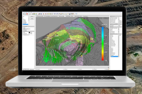
IDS GeoRadar out to improve productivity in radar slope monitoring with Hi-Sense

IDS GeoRadar, part of Hexagon, has launched the new Hi-Sense algorithm for Guardian, IDS GeoRadar’s software for slope monitoring.

Hi-Sense is the new state-of-the-art algorithm, embedded in Guardian software, aimed at improving productivity in radar slope monitoring.

The company explained: “Fast-changing atmospheric conditions are the greatest challenge in slope monitoring and IDS GeoRadar was the first to introduce on the mining market an advanced management of atmospherics. With the new Hi-Sense algorithm the management of atmospherics in radar slope monitoring is furtherly up-scaled to provide the cleanest view on displacements, even in challenging weather conditions.”

With the new Hi-Sense algorithm, effects introduced by fast-changing meteorological conditions, such as stormy weather, are processed with unparalleled fidelity, facilitating the interpretation of data and improving productivity in radar slope monitoring: reduced false positives and extended sensitivity to a wider range of movement trends, the company explained.

Even in fast-changing atmospheric conditions, Hi-Sense can support users providing the cleanest data output on radar maps, enhancing the possibility to anticipate the detection of instabilities and leading to an improved risk management in radar slope monitoring, according to IDS GeoRadar.

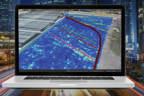
IDS GeoRadar extends reach of IQMaps software for ground penetrating radar systems

IDS GeoRadar, part of Hexagon, has announced it is extending the IQMaps software application to a wider range of ground penetrating radar (GPR) systems.

IQMaps is IDS GeoRadar’s post-processing software application for advanced GPR data analysis, enabling fast interfacing between the user and GPR data, it says.

IQMaps is now available for:

  • IDS GeoRadar Opera Duo: a compact, easy-to-transport and easy-to-deploy ground penetrating radar leveraging robustness, data quality and intuitiveness for unparalleled utility location and mapping;
  • IDS GeoRadar RIS MF Hi-Mod: a GPR array solution enabling a high resolution survey while guaranteeing a great depth range;
  • Leica DS2000: a highly manoeuvrable detection radar to detect and position underground utilities before digging; and
  • Leica DSX: an all-in-one utility detection GPR system designed for civil construction and straightforward mapping solution for underground locating.

IQMaps software is a customisable processing and analysis tool with a step-by-step approach that guides users in performing the best and the quickest data analysis for utility mapping, the company explains. The software uses real-time data processing to optimise target management and 3D visualisation of radar data from underground utilities surveys.

Extending the compatibility of IQMaps post-processing software to additional GPR systems makes fast real-time processing and visualisation available for a larger number of users, according to the company. Designed to perform rapid radar data analysis, IQMaps enhances and simplifies overall data management so that professionals can benefit from increased productivity in utility mapping and detection projects through faster data interpretation.

IDS GeoRadar adds artificial intelligence layer to slope stability monitoring process

IDS GeoRadar, part of Hexagon, has announced a new solution for geotechnical professionals that, it says, pioneers the introduction of artificial intelligence in slope stability monitoring – Ai.DA, the AI-based software monitoring tool for Guardian.

Ai.DA is an artificial intelligence-based software tool providing an additional smart processing layer to radar data. Ai.DA, through the use of algorithms, simplifies the identification of movements from possible residual noise by evaluating the consistency of the detected movement trend with typical slope instabilities behaviours and models, helping professionals to optimise processes and take better decisions, IDS says.

Ai.DA is an intelligent support to radar data interpretation and is fully integrated with Guardian, IDS GeoRadar’s software to manage slope stability risks in both open-pit mining operations and natural geo-hazards. Guardian’s processed radar data is automatically pushed to Ai.DA providing an additional smart processing layer that highlights quick moving areas through an intuitive interface with a clear and detailed view on a 3D map.

Ai.DA can provide simultaneous data processing of radar data originating from one to six different radars and
highlights timely localised and quick moving areas, which are often difficult to manage, for improved decision making, the company says.

“With Ai.DA, we are pioneering the use of artificial intelligence in slope stability monitoring, and we commit to providing customers with state-of-the-art technology solutions to support radar data interpretation,” Angela Patera, Guardian Product Owner at IDS GeoRadar, said. “Interpreting the big amount of available data is the new challenge for geotechnical engineers and Ai.DA represents a valuable support to this demanding task.”