Tag Archives: mine mapping

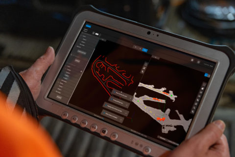
Sandvik reinforces autonomous vehicle navigation with mapping solution

Sandvik Mining and Rock Solutions has introduced the AutoMine® Mapping Solution, an innovative new product designed to, it says, maximise productivity and improve safety of autonomous vehicle navigation in underground mining operations through the use of mapped data.

The AutoMine Mapping Solution is Sandvik’s next generation product that enables a vehicle to safely record an underground 3D environment with a mine mapping tool, and convert 3D maps to 2D. Faster configuration, and the possibility to continue to operate other equipment within the area while it is being mapped, increases productivity and efficiency, it says.

Innovative technology within the solution reduces the time and cost involved in manual mapping and enables a safer, more efficient autonomous underground operating environment. It can be used on all types of underground equipment (LHDs, trucks and drills), eliminating the need for dedicated equipment and resource to map the area.

“With AutoMine Mapping Solution, we are progressing to the next generation of innovative automation solutions, bringing new technologies to the underground mining industry which are designed to maximise our customers’ productivity and safety,” Ty Osborne, Product Line Manager Underground Automation Sales at Sandvik Mining and Rock Solutions, says.

“AutoMine Mapping Solution is easy to use and turns real-time data from the mine into 3D models, providing a clear customer advantage in the planning and prioritising of their automated operations and increasing production control.” says Osborne.

The solution will be available to order later in 2022.

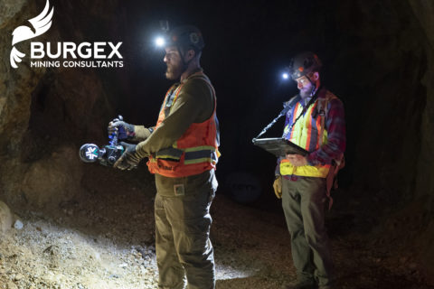
Burgex adds ExynPak LiDAR capabilities to mine mapping offering

Burgex Inc Mining Consultants has announced newly acquired in-house capabilities to provide high accuracy mapping of surface and underground mine workings with the addition of the ExynPak from Exyn Technologies to its fleet of mining and mineral exploration solutions.

With a gimballed Velodyne LiDAR sensor and the ability to provide real-time 3D mapping with survey-grade accuracy, the ExynPak is the leader in high accuracy handheld mapping for mining and exploration applications, according to Burgex. Simultaneous Localisation and Mapping (SLAM) provides accurate, survey-grade 3D mapping in real-time without the use of GPS, it added. This delivers precision mapping in underground mining environments that have been traditionally difficult to map using modern methods.

“The ability to map underground and surface mining workings in high resolution provides an enormous advantage to mine planning and mineral exploration projects,” Burgex said. “With LiDAR capabilities of over 600,000 points per second and a 360° horizontal field of view, it is possible to quickly identify slopes, faults and other geological features in real time. In addition to generating <3 cm accuracy point clouds in real time, the ExynPak is also equipped with two FLIR Chameleon3 RGB cameras that are capable of colourising points – providing yet another layer of functionality to geologic mapping and mine planning projects.”

Leveraging portable LiDAR with aerial data collection provides a new level of flexibility in modelling for mining and mineral exploration projects that is not offered at many, if any, other mining consulting firms in the US, Burgex said. Combined with aerial mapping, the Burgex team can pin underground and surface LiDAR surveys to geo-referenced base surveys and maps – creating a completely modelled project that can be used for mine planning, exploration programs, and more.

Additionally, Burgex Mining Consultants has recently added a DJI Matrice 300 RTK (M300) to its fleet of UAVs, providing even greater capabilities for aerial data collection.

“Not only can the M300 collect data more efficiently that other UAVs, but it can also simultaneously carry up to three payload sensors,” the company said. “The M300 has a max transmission range of up to 9.3 miles (15 km) with a 55-minute maximum flight time. The IP45 water and dust protection ratings and expanded operating temperatures will enable operation in a broader range of field conditions.”

Stuart Burgess, CEO and Co-Founder of Burgex Inc, said: “We are very excited about the addition of this new equipment and the new services we will be able to provide for our clients. From underground to surface, we’ll be able to map and model projects quickly and with centimetre accuracy, which is something that used to be very difficult and expensive to achieve, especially in underground environments. These new tools represent the next generation of mining and mineral exploration advancements.”

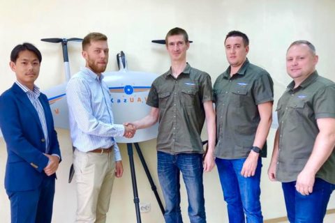
Terra Drone branches out into Kazakhstan UAV market

Japan-based Terra Drone has continued with its global expansion, having invested in a leading UAV company in Kazakhstan, KazUAV.

With this investment, KazUAV joins Terra Drone’s network of over 25 group companies and technology partners committed to providing cutting-edge yet cost-effective drone services across the globe, the leading drone solution said.

Terra Drone said: “Established in 2016, KazUAV is a known name in Kazakhstan’s drone ecosystem, having provided GIS services to several government agencies and private companies.”

In 2018, at the request of the International Civil Aviation Organization, KazUAV mapped six airports in the country, totalling a surveyed area of 4 million hectares. The company is also registered to provide surveillance drone services to the Kazakhstan special forces.

As part of the Terra Drone group, KazUAV will be able to leverage technologies to provide various drone-based services and solutions in Kazakhstan, Terra Drone said. These include power line inspection and vegetation management for the energy sector; onshore/offshore infrastructure inspections, tanks inspections, and non-destructive testing for the oil and gas industry; and open-pit and underground mapping services for the mining sector.

Terra Drone already has more than 25 group companies in its network. Just last year, Terra Drone acquired a majority stake in Europe-based drone service provider Skeye, in addition to making an investment in Sweden-based Inkonova.