Join us at The Electric Mine 2026
The Electric Mine 2026
Get IM Free
DOWNLOAD IM
Videos/Webinars
Interviews
Webinars
Videos
2025 Media Pack
Events
Pay Online
Contact
The Electric Mine 2026
Get IM Free
DOWNLOAD IM
Videos/Webinars
Interviews
Webinars
Videos
2025 Media Pack
Events
Pay Online
Contact
IM Magazine
IM Magazine Archives
Past Events
The Electric Mine | Perth 2024 photos
The Electric Mine | Tucson 2023 photos
The Electric Mine | Toronto 2019 photos
Event Papers
The Electric Mine 2023 Conference Papers and Videos
The Electric Mine 2022 Conference Papers
The Electric Mine Virtual Conference 2020 Papers
The Electric Mine 2019 Papers
Helpful Links
Filter by:
All Topics
Automation
Base metals
Bulk handling
Careers in mining
Coal technology
Comminution of minerals
Communications in mining
Diamond mining
Energy minerals
Environmental
Equipment maintenance
Explosives and blasting
Gem stone mining
General
High tech minerals
History of mining
HOF
Industrial minerals
IoT
Marine mining
Metallurgy
Mine operation news
Mine shafts and equipment
Mine surveying
Mine ventilation
Mineral commodities
Mineral exploration
Mineral processing
Mineral project development
Mining consumables
Mining equipment
Mining events
Mining finance
Mining industry recognition
Mining maintenance
Mining mergers and acquisitions
Mining people
Mining policy
Mining project news
Mining safety
Mining services
Mining software
Mining techniques
Power supply for mines
Precious metals
Spotlight Feature Article
Steel and iron ore
Sustainable mining
Uncategorised
Uncategorized
Undersea mining
Videos
Water management
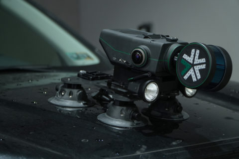
28 Feb 2024
Exyn launches Nexys, a modular 3D mapping solution for mining sector
Exyn Technologies has announced Exyn Nexys, a cutting-edge modular 3D mapping solution specifically designed to...
Read More
30 Apr 2023
Jaguar Mining to deploy ExynAero autonomous robot for cavity monitoring in Brazil
Exyn Technologies and NSS Canada say they have expanded their footprint with Jaguar Mining in...
Read More
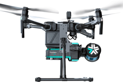
03 Oct 2022
Exyn’s drone-based mining autonomy ambitions taking flight
Having already achieved the highest documented level of aerial autonomy – level 4A – with...
Read More
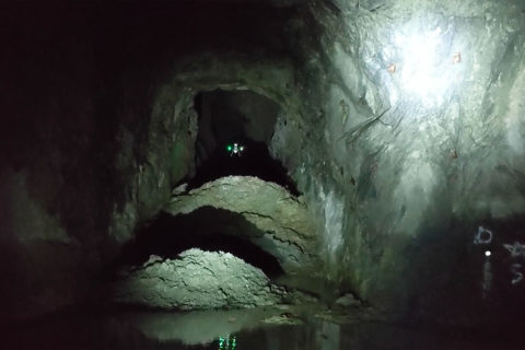
02 Mar 2020
Exyn drones help Rupert Resources map Pahtavaara gold mine
Exyn Technologies says it has completed a successful mission for Rupert Resources at its historic...
Read More