Tag Archives: sensors

U&M and Hexagon ready to deploy AHS solution at Brazil mine

U&M Mineração e Construção S/A, as the largest native open-pit mining contractor in the Americas and one increasingly focused on sustainability, is about to embark on a major autonomous haulage project that could prove transformational for all sizes of mine sites across the globe.

The company has been busily working on an in-house Autonomous Haulage System (AHS) for several years, enlisting the help of Hexagon’s Mining division back in 2020 to ensure what it delivered to the market was a commercial proposition with widescale applicability, IM discovered this week at HxGN LIVE Global 2023 in Las Vegas.

Now the companies are ready to deploy their combined OEM-agnostic AHS solution at a mine in Brazil, starting next month, as part of a plan to bring two AHS-enabled retrofitted Caterpillar 777 trucks to the operation.

The collaboration is seeing U&M carry out all mechanical changes to the 100-ton-class payload trucks to make them automation-ready without disturbing the OEM system. The contractor is also in charge of the navigation system and software that the trucks will run on – the ‘autonomous driver’ as it could be termed.

Hexagon, for its part, provides the HxGN Autonomous Mining Mission Manager Solution to optimise the movement of autonomous and non-autonomous vehicles, and mine production activities through one interface; the World Perception solution to enable object detection, operator vehicle-to-vehicle and vehicle-to-person awareness; and some additional on-board infrastructure – such as sensors and an antenna.

This, according to the companies, makes for an autonomous contractor solution that can be rolled out anywhere in the world.

“What we are creating is a scalable platform that can be used on any truck,” Mauricio Casara of U&M says

“The first project may involve Cat 777s, but what we are creating is a scalable platform that can be used on any truck,” Mauricio Casara, Commercial Director at U&M, told IM. “We are looking to improve on the legacy AHS solutions by making automation available to any size of mine with any type of trucks.”

As part of the company’s R&D work to this point, it has also retrofitted an autonomous solution on a Komatsu 730E, with that truck running at its proving grounds in Brazil.

Interestingly for this proof of concept involving the two Cat 777s, the plan is to enable the trucks to interact with both autonomous and manned vehicles in the haulage cycle from the off: an interaction that the traditional AHS providers have only just started to work on after more than a decade of industry deployments.

This is just one of the hurdles the solution will overcome, according to Andrew Crose, Vice President, Autonomous Mining, Hexagon’s Mining division.

“The world perception sensor stack that we have on board these machines will allow us to distinguish between trucks, light vehicles, berms, people and many other objects,” he said. “By leveraging this, we can ensure the trucks operate as safely as possible while being as productive as possible. That is key to achieving buy-in from all stakeholders involved.”

While the official partnership for this project was not signed until 2020, U&M has been utilising the GNSS positioning smarts of Hexagon – through the NovAtel business it acquired – for many more years.

This same GNSS solution is being leveraged in the two-strong autonomous truck trial along with V2X, 4D Radars,  ultra-wideband time-of-flight systems and more.

Crose added: “It’s worth mentioning that around 60% of the autonomous machines running in the field have some Hexagon solution on them. We are sometimes providing the positioning, world perception, fleet and mission management, onboard autonomy and by-wire, all part of our interoperable strategy.”

While this initiative is inevitably going to pique the interest of those companies in charge of running these autonomous trucks, U&M has no plans to compete with the likes of Caterpillar and Komatsu when it comes to manufacturing automation-ready trucks.

“There are so many existing trucks out in the field that our clients are running; all of which can be retrofitted with the solution we are working on,” Casara said. “The whole industry talks about sustainability and how to mine sustainably, but the sustainable solution to achieving autonomous operations is not to build brand new trucks and equip them for automation; it is to retrofit the smarts onto them to enable that automation.

“This is the sustainable way to roll out the automation needed across the sector to achieve mining companies’ productivity and decarbonisation goals.”

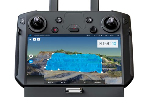
Skycatch maps out autonomous mining future with DJI M300 mapping, analytics solution

San Francisco-based Skycatch has been making waves in the drone space with a range of mapping solutions tailored for mining applications but, according to Chief Technology Officer, David Chen, it thinks of itself as a “software-first company”.

He explained to IM: “We are really a computer vision company, and we focus on building not only the drone solution, but the software that enables it.”

This sees the company provide data capture automation, processing, visualisation and analysis tools to the industry for efficient decision making.

Chen added: “We work with a number of the top mining companies across the globe, providing them with unique solutions that they are using every day to complement their existing survey processes.”

The company, which has become a leader in highwall mapping through these solutions, is expanding beyond surveys into other areas.

This will be facilitated through software like its Flight1X, a cloud-based solution designed specifically for the recently launched DJI M300 drone that, Skycatch says, delivers unprecedented drone mapping accuracy and inspection automation for operations like mines. The proprietary software offers the most complete end-to-end high precision industrial drone capabilities available today, according to the company.

Flight1X, launched at MINExpo 2021 today, comes with proven data and network security via Skycatch servers in the USA, with the Android-based flight planning application running on the M300 Smart Controller. When combined with Datahub, Skycatch’s cloud-based solution, the pair offer mission planning and data visualisation.

Chen expanded on some of these capabilities.

“The majority of drone software out there has been focused on 2D mapping, whereas we have seen that mining, which comes with dynamic and undulating terrain, requires something different.

“What we are building is an automated mission planner where the primary view is of 3D terrain. This planner allows you to bring in existing terrain data from elsewhere or capture and process data from our own platform. The user can then rotate around this map and see the exact mission profile in 3D for improved visualisation and decision making.”

This data integration piece, which hinges on the cloud-based Flight1X platform, could provide Skycatch with an ‘in’ to the tailings dam monitoring market.

“While we’re already providing some survey solutions for tailings dams, the combination of high precision survey (with cm-level precision) for dam movements, fully automated section missions based on RGB and thermal imaging, and machine learning could provide data on dam seepage, for instance,” Chen said.

“We also want to integrate IoT sensors around dam movement and other areas into this cloud-based platform to provide an overall view of the tailings management facility.”

Skycatch is currently working on integrating the DJI M300 and L1 & P1 sensors – purpose built for mapping and surveying – into its offering, with Chen seeing the process as just the next stage in facilitating the autonomous mine of the future.

“The one thing that fully autonomous mines need is a map of the mine for these autonomous machines to operate off,” he said. “We have a focus on making data more accurate, accessible and faster; making it faster is the key for fully autonomous mining.

“Right now, with the current photogrammetry process, it’s still: capture, process and wait a few hours for a map. To be fully autonomous, you need that dynamic map in near real time, which is what we can offer the industry.”

Hexagon reveals two new autonomous reality capture solutions

Hexagon AB has announced the introduction of the Leica BLK ARC and the Leica BLK2FLY, extending its BLK series of autonomous reality capture solutions.

The Leica BLK ARC is a laser scanning sensor purposely built to improve the autonomous navigation of robots and other carrier platforms to deliver fully autonomous mobile laser scanning, Hexagon explains.

Combining its speed, accuracy and versatility with robotics, the BLK ARC addresses the growing demand for autonomous solutions that can safely and repeatedly capture accurate 3D point clouds and panoramic images of changing environments with minimal user intervention, it added.

The Leica BLK2FLY is the world’s first fully integrated, autonomous flying laser scanning sensor, the company claims.

“With a few simple taps on a tablet, users can quickly and easily scan structures and environments accurately and entirely from the air,” the company said. “The airborne scanning provides value across multiple industries in need of accurate data of inaccessible or hard-to-reach areas (eg façade projections, rooftops), ensuring complete capture of a structure’s exterior features and dimensions.”

The BLK ARC and BLK2FLY connect directly to Hexagon’s cloud-based visualisation platform, HxDR, where immediate data upload from the field, artificial intelligence-enabled cloud processing and storage of the captured data enables instant delivery of a purpose-built smart digital reality to anyone who needs it.

Hexagon President and CEO, Ola Rollén, said: “The BLK2FLY and BLK ARC illustrate Hexagon’s commitment to empowering an autonomous future with smart digital realities. The purposefully integrated sensor-software systems are tailored to bring autonomous agility and speed to any reality capture workflow. The robots, sensors and software work together, dynamically adjusting reality capture missions to offer seemingly limitless business applications – from as-built site documentation for buildings to monitoring and situational awareness of remote or hazardous environments, such as mines, factory floors, off-shore facilities, fire investigations and more.”

While the first robotic compatibility for the BLK ARC is with the Boston Dynamics Spot, it can be integrated with other autonomous robotic carriers, according to the company.

The BLK2FLY introduces the next generation of flight safety with advanced autonomous obstacle avoidance. Sensor fusion of LiDAR, radar, cameras and GNSS ensures optimal and safe flight paths, it said.

HARD-LINE readies Auto RockBreaker, TeleOp Assist and Brow Alert for MINExpo crowd

HARD-LINE plans to unveil a diverse line-up of new mining products geared towards automation and safety at MINExpo 2021 next month.

The company’s Auto RockBreaker, TeleOp Assist and Brow Alert will be just some of the company’s booth highlights from September 13-15, in Las Vegas.

HARD-LINE’s Auto Rockbreaker is going to “disrupt” the mining industry, according to the company.

“For the first time ever, operators will have the ability to automate many rockbreaking tasks” HARD-LINE said. “With Auto Rockbreaker, mining companies will be able to reduce maintenance and operator training costs, decrease wear and tear while extending the life of all rockbreakers.”

The system has many functions, including auto deploy and auto park, as well as other features making the operator experience that much more intuitive with its 3D User Interface, it said.

TeleOp Assist is the latest addition to the company’s TeleOp suite, which equips the base TeleOp system with intelligent steering assistance and collision detection to keep machines off walls while driving.

Using real-time 3D LiDAR scans, Assist will automatically steer to handle the articulation adjustments required to keep the machine as centred as possible within the drift, the company said.

“With Assist’s adaptive technology, a pre-scan of the drift is not required – providing significant cost savings,” HARD-LINE said. “The system does not require any training when moving from one level to another.”

Brow Alert, meanwhile, is an added level of protection for underground mining operations.

It serves as an add-on system designed to deter an operator from manually driving a vehicle past the brow line of a stope by using sensors and modules.

The system is easy to install, reduces risk of workplace injuries and fatalities, encourages accountability and keeps operators a safe distance from the brow, the company says.

Auto RockBreaker, TeleOp Assist and Brow Alert will be joined by the likes of RRC (Radio Remote Control), TeleOp system, vehicle conversion kits (drive-by-wire), and HARD-LINE’s low-profile loader series (LP401 and LP301) on the company’s MINExpo booth.

CRC ORE simplifies complexity for value

“There are a lot more variables to bulk ore sorting than just the technology,” Jon Rutter says.

The Principal Geologist of the Cooperative Research Centre for Optimising Resource Extraction (CRC ORE), Rutter knows his stuff. He has worked underground in both narrow-vein and mass-mining operations, as well as at large scale open-pit mines; in the base and precious metal arena.

During a presentation at International Mining Events’ IPCC Virtual event in early-February, he shared a slice of this knowledge while reviewing a recent installation project CRC ORE had been involved in at a platinum group element (PGE) operation.

“The intrinsic value of bulk ore sorting comes from the delivered heterogeneity,” Rutter said. “We have got to be able to sense and divert a higher-value pod of material versus an adjacent pod of lower-grade material on a conveyor.

“You essentially want to put more material into the mill that adds value – and not what destroys value.”

Looking at the wider bulk sorting opportunity in mining, Rutter explained the sensor diversion units (SDU) in bulk ore sorting were smaller than what the mine itself can typically offer in the form of a selective mining unit (SMU), which may be comprised of a dig block totalling around 15,000 t.

A truck offers a 100-300 t opportunity, while a shovel typically comes with a 50-100 t opportunity.

Even with a modest conveyor running at a 2,000 t/h rate, an on-board sensor (eg PGNAA or PFTNA) running at a 30 second integration time (the time to analyse one grade) would provide an SDU of 16.7 t. A sensor with lower integration time (eg XRF at 10 seconds) comes in at 5.6 t.

The ability to provide analysis down to this level has enticed several major companies into testing bulk ore sorting solutions.

Anglo American has trialled bulk ore sorting solutions at copper and platinum group metal mines, while BHP recently engaged CRC ORE to examine deployment of cutting-edge preconcentration techniques under its Grade Engineering® platform at the Olympic Dam mine, in South Australia.

The SDU with bulk sorting may be that much smaller than the SMU of a typical mine plan, but lab-level precision is not required for these solutions to work, according to Rutter.

“What I need is the ability to measure the metal content adequately,” he said. “When I say adequate, this incorporates the entire error bar of the system. That system includes the inherent geology, the mineralisation style and heterogeneity. We also need to consider the precision, accuracy and integration time – which is the technology constraint; but we also need to include the weightometers, the flop gates, the diversion gates, as well as that entire mining and materials handling process right from the start – from blasting, loading, hauling and dumping to the plant.

“But for bulk ore sorting what I end up requiring from this combined data is usually a binary decision: am I above or below a certain threshold?”

He expands on the bulk ore sorting (BOS) assessment process: “The other way of looking at this is simply considering it as planned ore loss and dilution. If we go back into that dig block, in that 15,000 t of material, I’ve already incorporated planned ore loss and dilution decisions or parameters into that SMU decision. So, if we look at bulk ore sorting, I am just talking about those different attributes – the error bars of a BOS system – as the inputs or parameters for BOS planned ore loss and dilution – it’s now just at a smaller and more precise opportunity.”

The company took a two-phase approach to the BOS opportunity at the PGE operation in question.

The first phase involved carrying out heterogeneity analysis of the orebody; correlation analysis of PGEs to base metals; selection of sensor technologies (XRF and PGNAA were selected in this case), design, layout and equipment selection for the bulk ore sorting plant; natural deportment analysis of the orebody; development of a preliminary business case; the ore type selection and sampling strategy; and project planning and management.

CRC ORE and the company in question settled on a solution where a Caterpillar 992 wheel loader dropped material off to a system using a combination of grizzly, feeder, sizer, conveyors, diverter, stackers and associated equipment from MMD, used in conjunction with an ore sensing system equipped with both PGNAA and XRF sensors to continuously measure the elemental composition. The PGNAA sensor provided a “penetrative” analysis calculation whereas XRF provided a “surface” sensing calculation, Rutter explained.

An incline conveyor ahead of the diverter gate and the accept/reject stream provided the 30 second integration time the PGNAA analyser required.

Phase two of the project involved online and offline (pre-install) work; sensor calibration; proving the technology; and proving the technology can drive physical separation.

Rutter said the completion of static calibration of the sensors saw the PGNAA sensor 20-30% calibrated, and the XRF sensor 70-80% calibrated.

This outcome harked back to Rutter’s assertion that “bulk ore sorting implementation is not a plug and play opportunity”.

A dynamic calibration in online mode completed under normal conditions was required to get the PGNAA sensor up to speed. This process, meanwhile, solidified the operation of the XRF sensor.

While the two sensors were calibrated in different ways, Rutter showed data that confirmed both were in unison when it came to reading the ore/waste that came through the conveyor (see right-hand graph below).

“The two sensors are independent of each other and fundamentally very different, but they can work well together, or separately,” he said.

CRC ORE was able to prove the technology by running the same sample through the circuit a number of times, as Rutter explained: “We fed 15-20 t of run of mine material into the hopper and repeated the process 15 times, putting the same 15-20 t sample through the system. We could then start to determine the precision and accuracy of the sensors and the system.”

For further verification, the sample was crushed, sub sampled and assayed.

“We wanted a binary response to ore and waste to build confidence,” Rutter added.

Phase three involved the ramp up to production scale, going from, say, 500 t/h to 1,000 t/h; carrying out validation by campaign; and finally integrating with the operation.

There were several lessons all mining companies – and bulk sorting vendors – should keep in mind from such a project, Rutter said.

Operations need to assess the impact of mixing across the entire materials and mining handling process as soon as possible, for one.

“The earlier we can put this data into the system, the better,” Rutter said. “Without a heterogeneity signature, we cannot implement bulk ore sorting.”

He also stressed the importance of timely feedback. Sensor calibration, a secondary crushing/sampling plant and assaying were all required to build confidence in the solution.

Rutter added: “The proper calibration of sensors does require a considerable and ongoing effort…but that is no different from any other process plant or equipment.”

Operators also need to be wary of where they set these solutions up in mines, recognising this heterogeneity dynamic.

“Bulk ore sorting is quite unlikely to be universally suited to the entire deposit,” Rutter said. “The analogue for this is a flotation plant; there are ore types in the mine where you achieve better performance in the flotation plant and others where you get worse performance.”

Mine sites testing out CSIRO, Mining3’s precision mining concept

CSIRO and Mining3’s wide-ranging precision mining concept looks to be gaining momentum with multiple mining companies testing out aspects of this innovative notion to reduce the footprint of future mine sites.

Among the headlines from the organisations’ latest report on this technology was its ore sorting technology, NextOre, has three trials underway at mine sites, with up to three more systems to be delivered this year.

A Chilean copper mine is testing up to 10 types of sensors, complementing other recent trials in Australia and CSIRO desktop studies. Another study found that a mining company could make the same profit as it is now, but with a 30% reduction in capital and operating costs.

In this pursuit, the mining industry can learn a lot from medical science, according to CSIRO Research Director in Precision Mining and Mining3 Research Leader, Ewan Sellers.

As the CSIRO rock mechanics specialist says, modern medicine has used technology to better understand and treat illnesses and injuries while reducing the impact on people. Sellers is now working towards creating low impact “zero entry mines”.

CSIRO explains: “Precision mining is the industry’s version of keyhole surgery. Once a deposit is discovered, precision mining aims to target the ore and extract the deposit as economically and sustainably as possible.”

CSIRO and Mining3’s shared vision is for mines of the future to be mostly underground, remotely operated by robotics, with minimal or remote offices and a very small environmental footprint. All waste would be used to make other products.

Sellers believes this vision could become a reality for most mines within 20 years, as vast mining operations that leave large scars are consigned to history.

Minerals 4D

Key to enabling precision mining is a concept CSIRO is leading called Minerals 4D.

Minerals 4D ‘intelligence’ aims to image minerals in the subsurface and predict their distribution. By integrating sensors and specialised imaging techniques tied with data analysis and machine learning, miners can better understand the orebody and quantify the rock mass at multiple scales.

Precise cutting, blasting and in-mine processing techniques can then accurately target the ore and leave the waste behind. Miners can focus on the most economic part of the deposit, reducing the need to move, crush and process massive amounts of rock, saving significant amounts of energy, water and waste.

CSIRO said: “Although information about the grade of the material and type of rock may currently be known over a block or at mine scale, Minerals 4D aims to add information about the mineralogy at a much smaller scale. This will enable companies to target the orebody and characterise the rock mass more accurately to increase efficiency at the processing plant.”

Rob Hough, the Science Director for CSIRO Mineral Resources, says Minerals 4D is about adding a time series to three-dimensional (3D) data. Essentially, it’s about tracking mineralogy over time.

The mining industry is now capable, through its geophysical sensing technology, to create extremely accurate 3D spatial models of orebodies, but 4D adds in the critical time element – tracking that mineralogy through the metal production line as if it were a barcode in a manufacturing circuit.

The concept involves linking modular mining operations to sensors – including fibre optics and systems attached to robots – to precisely characterise material in the subsurface before mining, through to a mine face, bench, conveyor, stockpile, truck, train or a ship.

Then you can measure the chemistry, mineralogy and rock structures at a range of scales, and provide unprecedented detail and volumes of data that capture ore and waste variability. Measuring the mineralogy is critical to understanding the quality, so where the value is created and lost.

This is like the artificial intelligence algorithms that companies such as Petra Data Science are developing to track ore from the pit to the processing plant.

A focus on value, rather than volume, means less waste and emissions in this context.

“If you have the knowledge of what you’re dealing with in a 3D picture you can then start to make predictions as to how minerals will perform when you go to mine, through to process and beneficiation,” Hough says.

“Operators can choose one set of mining or processing systems over another, knowing the texture and hardness of a material. We need to understand what is in the rock mass in terms of the minerals, but also how hard it is, its strength and how it breaks up to best separate the ore from the waste rock.”

Drone-deployed sensors

It is now possible to produce a detailed face map of a mine, fly a drone with spectral sensors to image surface mineralogy and use data analytics to identify correlations between ore types and rock strength. X-ray diffraction is also being used for analysis. These instruments are applied to samples in the field, drill holes and at bespoke laboratories that run thousands of samples at a low cost in order to build a 3D mineralogy model.

“We have a range of sensors available, but we don’t yet have a fully ‘sensed’ mine,” Hough adds.

“What we’re missing is all sensors in place, in a given operation. We’re also missing the assembling of data to inform decision making throughout the process as it happens – we need that information conveyed in real time and viewed in our remote operations centres.”

Advanced sensor-based ore-sorting

CSIRO partnered with RFC Ambrian and Advisian Digital to launch joint venture, NextOre, to deliver a sensor that intelligently directs a conveyor – sorting valuable ore from waste. CSIRO said NextOre has three trials of the sensor system underway at mine sites, with up to three more systems to be delivered this year.

“On the back of better data, we should be able to take advantage of applied mathematics that will then allow us to move to artificial intelligence and machine learning,” Hough says. “I can see a real-time conveyor belt start making automatic decisions about what is coming down the line. It’s the ultimate sensing and sorting solution.”

Reducing energy and water use

Sellers believes a move to precision mining can improve the conditions for communities living nearby mines, and even improve the social acceptance of mining.

He said several companies are testing out the value cases of sensors and data integration, and he understands they need to see proof that precision mining works on the ground. The economic benefits of sensing were demonstrated recently at a Western Australia iron ore mine, where A$25 million ($17 million) of additional resources were discovered using data provided by a relatively inexpensive hyperspectral sensor, according to CSIRO.

A Chilean copper mine is testing up to 10 types of sensors, complementing other recent trials in Australia and CSIRO desktop studies, it said. Another study found a mining company could make the same profit as it is now, but with a 30% reduction in capital and operating costs.

“Once miners gain confidence that we can actually do this, I think it will take off very quickly,” he says.

Precision mineral exploration and discovery

Beyond the mine itself, tracking minerals over time – in 4D – will also benefit greenfields exploration upstream.

According to CSIRO Digital Expert, Ryan Fraser, implementing the Minerals 4D concept is at its most challenging at the exploration and discovery stage – the point where data are sparse, and little is known about a potential target orebody.

“For example, we know a lot about a deposit such as Mount Isa, including how it forms. So, can we use the intelligence we have of that mineral system to foresee where the next Mount Isa will be?” he asks.

Fraser says if we understand how mineralogy evolves over time and the overall geological process, we can then look for signatures across the Australian landscape that help to identify similar things.

“Normally you drill in these spots, take back samples, check data and then in about two years you might have some idea of what’s under the surface and have some idea of mineral boundaries.”

The new sampling techniques will be far quicker and more efficient, he says.

“Instead of sampling a sparse, evenly spaced grid, we use machine learning to reduce uncertainties and guide where to sample and that will enable us to do much smarter edge detection of mineral boundaries,” Fraser explains.

Already this kind of predictive work has been tested in a project for the South Australian (SA) government at Coompana in SA with surprisingly accurate results and significant cost savings over traditional methods, according to CSIRO.

Other key challenges that researchers and the industry are working to address to make this a reality, include designing and developing sensors robust enough to work effectively in the mining environment (for example, in robotic cutting machines) and across rock types, and understanding which sites in the mine process are most suitable for sensors.

CSIRO concluded: “These sensors will be linked to precise and automated drilling, cutting and blasting technologies under development through Mining3 to transform the way that mining is performed.”

Schenck Process filling screen performance data gaps with sensors

Schenck Process says performance data provided by extra sensors fitted to a prototype vibrating screen is substantially improving the understanding of operation of the equipment.

The data is also giving indicators about the overall performance of the processing cycle, according to the company.

Designed and developed in Australia by Schenck Process, the prototype screen is undergoing site trials, but the company already believes the new screen has the potential to change the way vibrating screens are developed and operated.

The standard condition monitoring system comprises two sensor nodes including six degrees of freedom MEMS accelerometers, a high-resolution accelerometer and a temperature probe. On the prototype screen, four additional sensors have been fitted, one on each corner.

Schenck Process Senior R&D Engineer, Doug Teyhan, said: “The measurement regime for the additional sensors includes spring amplitude and mean compression, allowing the estimation of tonnage and load bias (to determine if the feed is presented square to the screen or favouring a side) and the determination of spring operating characteristics and cumulative fatigue damage.

“We are also looking into the development of a predictive failure program to improve overall productivity and efficiency and significantly reduce the possibility of unplanned downtime.”

Historically, failure prediction has been determined by running components to the point of failure and assessing a mean time to this point based on a known operating history.

“The data generated by the prototype screen is utilised to estimate the operating stress of the screen at the most aggressive fatigue areas and assessing the cumulative damage of those areas based on the measurement of non-ideal operating characteristics,” Schenck Process said.

Using a Cumulative Damage System, which counts machine cycles and trend characteristics that have the potential to adversely affect vital component life expectation, the plan is to make the machine monitoring system a lead measure in predicting the potential for component failure, Schenck Process said.

“The expanded monitoring system will also provide input into machine development of the next generation of vibrating screens by filling in the unknowns in the design process with real-time field data,” the company said.

According to Teyhan, the benefits for the customer – including increased availability and improved screen performance – are substantial and have the potential to initiate improvements in the processing cycle.

“And, from a screen operation point of view, the additional data is bringing to light characteristics not previously known. It is highlighting transient feed characteristics – not visible using traditional condition monitoring techniques – that impact the loading of the screen and affect machine life expectation,” he said.

“We also believe there are potential industry-wide benefits, through new design parameters and possible changes to machine construction techniques and materials,” he added.

To optimise the greater range and scope of data the screen is generating, the company is collaboratively investigating and assessing other performance variables, it said. The potential is for control of the variability in the feed rate, more consistent performance and improved overall efficiency of the cycle.

Tailings monitoring could go autonomous, Mining3 says

Mining3 says it and The University of Queensland, in conjunction with the Australian Coal Association Research Program (ACARP), are currently in the process of building prototype autonomous sensors for the constant monitoring of tailings and spoil storage facilities.

The Australia-based company said: “Tailings impoundments are one of the largest man-made structures on earth and ensuring their integrity for the safety of human life, the environment and property are critical in today’s mining operations. Past and recent catastrophic tailings dam failures have placed an urgent need for improved waste disposal, storage processes and monitoring capabilities.”

Currently, the integrity of the tailings dam infrastructure is monitored by mining staff walking along the, potentially unstable, perimeter and visually inspecting the exterior. Piezometer-like devices are also placed throughout dams to measure changes in liquid pressure. “Combined, these methods provide subjective data that cannot deliver an ongoing and accurate assessment of the integrity of these waste storage facilities,” Mining3 said. “Without a reasonable assessment of these large structures, there is no way to identify if or when one might fail.”

With a web of small, interconnected sensors spread across a tailings dam or spoil dump, Mining3 says accurate measurements in the change of water pressure or movement in the soil can be delivered to the surface in real-time. “This provides up to date readings of environmental factors that can affect overall wall stability, limiting the need for staff on the ground,” the company added.

Mining 3 and the university’s research will also delve into identifying indicators and precursors to failures, in relation to data collected from these sensors. “This could revolutionise the understanding of these storage facilities. By understanding the causation, steps can then be taken to minimise risk in the future,” Mining3 said.

“The current project addresses key industry outcomes surrounding safety and the removal of personnel from hazardous situations such as those involved in ground stability, the investigation of material properties and their implications in the design and functionality of a dump site, and the investigation into aspects of effective mine closure and the long term impacts associated with tailings dams and spoil dumps.”