Tag Archives: slope stability monitoring

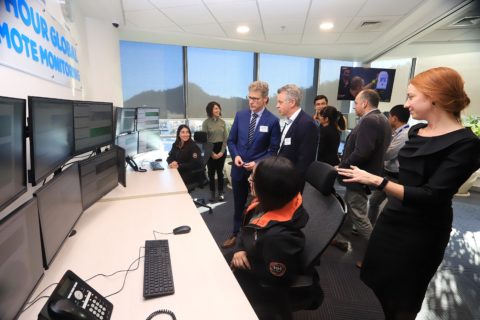
GroundProbe offers Brazilian customers dedicated geotechnical monitoring option

GroundProbe has opened a dedicated Geotechnical Support Service (GSS) monitoring centre in Belo Horizonte, Brazil, to, it says, better serve its growing customer base in the country.

The centre will provide 24/7 real-time remote radar and laser monitoring services for mine slopes and tailings dams.

The centre joins GroundProbe’s two existing high-tech monitoring centres in Santiago, Chile, and Balikpapan, Indonesia, to provide support in four languages – Portuguese, Spanish, English and Bahasa.

Monitoring live stability data and reacting to alarms to ensure the maximum safety of people and communities, the centre connects remote sites with geotechnical industry experts in real time, GroundProbe says. The centres are crewed by more than 100 highly experienced engineers and radar operators with extensive radar knowledge and experience.

GroundProbe, a wholly-owned subsidiary of Orica, is widely accepted as a global leader in real-time technologies used to detect instabilities and predict when mine and dam collapses will occur.

GroundProbe CEO, David Noon, said that the company had witnessed a huge increase in demand for remote geotechnical expertise in Brazil.

“We saw it as an absolute necessity to bolster our offering and extend our support services to the region,” he said.

“The state-of-the-art centre provides the most technologically advanced solution for remote monitoring in the region and shows our level of commitment to our customers there.

“It leans on our five-and-a-half years of remote monitoring experience, our recognised systems and processes and our established resourcing model, all of which ensures the highest level of data integrity and service availability.”

GroundProbe Head of Geotechnical, Peter Saunders, explained how the service’s positive results and statistics speak for themselves.

“Together, our GSS team have detected and provided early notification to site of 1,440 slope failures, validated 3,615 alarms and managed 44,608 unwanted alarms,” Saunders said.

“GroundProbe also has the world’s largest library of wall folders. Our experts have unprecedented access to this data, gaining a unique perspective on geotechnical monitoring borne from analysing thousands of slope failures and assisting with numerous incident investigations.”

This newest monitoring centre in Belo Horizonte will provide the same services to customers, including: GSS-Remote, GroundProbe’s 24-hour remote monitoring solution; GSS-Training, its specialised SSR and laser training service; and GSS-Reporting, the company’s customised analysis and reporting service.

GroundProbe’s SSR-Omni slope stability tech recognised at AEEA event

GroundProbe has taken out Queensland’s top award at the Australian Engineering Excellence Awards (AEEA), hosted by industry body Engineers Australia.

The awards recognise and celebrate Australia’s top engineering projects and the engineering teams behind them.

GroundProbe received this award for its SSR-Omni technology. The SSR-Omni is the world’s leading Slope Stability Radar (SSR) technology for monitoring and detecting movement and potential collapses across open-pit mines and tailings dams, GroundProbe says.

GroundProbe’s Head of Product Development, Fernanda Carrea, said: “Our product development department is comprised of a world-class team of engineers across a breadth of engineering disciplines, all working towards a common goal; ensuring maximum safety for our customers through trailblazing technology.

“It’s exciting and humbling for our engineers to be recognised by their peers as experts in their field for their excellent work. The award is especially meaningful considering it’s across all engineering disciplines and industries, not just within our particular focus.”

GroundProbe focuses on real-time technologies that help manage risk, ensure safety and increase productivity across mining and civil projects. In 18 years, the company has grown from a PhD project at the University of Queensland into the global technology and innovation powerhouse it is today.

The SSR-Omni is GroundProbe’s full-coverage, high-resolution system.

Using embedded super-computing on a chip, the SSR-Omni scan processes over 600 MB of raw data down to a fraction of the size, while proprietary algorithms also predict the time of collapse and display the data in 2D and 3D visualisations. The day-night camera system can stream multiple video feeds at different zoom levels back to the user for real-time inspections, according to the company.

GroundProbe’s VP Technology, Lachlan Campbell, said GroundProbe has always been at the forefront of innovation but prides itself on adapting its tried-and-tested mechanical engineering experience to solve new problems.

“Due to catastrophic tailings dam failures resulting in devastating loss of life, the market was looking for a solution to ensure maximum safety for their facilities and surrounding communities,” Campbell said. “We developed a technology that covers the broadest of areas, detecting miniscule movement at the earliest possible time. In 40 seconds, the SSR-Omni scans 360° and takes 37 million measurements in a 11.2 km diameter, showing movement of rock and ground of 0.1 mm precision.”

The SSR-Omni has been successfully deployed to mining customers around the globe, including sites across Australia, North America, South America and Africa.

Engineers Australia Queensland Division Manager, Stacey Rawlings, said of GroundProbe’s award-winning technology: “The SSR-Omni pioneering approach has created a world leading solution for stability monitoring of pits and tailings dams and is a worthy nominee to represent Queensland at the national awards.”

GroundProbe has also been selected as a finalist for the Sir William Hudson Award – the highest honour for a project awarded by Engineers Australia. The Pinnacle Awards Ceremony will be held in November where the Sir William Hudson Award and National Engineer of the Year Award will be announced.

Worldsensing to offer up IoT wireless monitoring expertise to Brazil miners

Worldsensing says it has joined the Brazilian Mining Association (Instituto Brasileiro de Mineração, or IBRAM) to help establish a favourable environment for mining business, competitiveness and development.

In particular, Worldsensing is hoping to extend the use of its remote, real-time data collection, monitoring and management systems to ensure greater safety and efficiency in Brazilian mining operations, it said. These systems are used in mines around the world from Sweden to Chile.

Through its Loadsensing product family, Worldsensing offers a range of wireless data acquisition technology aimed at enabling remote data collection in hard-to-access environments, predictive maintenance, reducing monitoring costs, ensuring workforce safety and managing environmental risks.

The wireless systems can be used for monitoring surface areas, tailings dams, leach pads and slope stability, as well as in deep excavations without line of sight.

Last month, the company joined up with IDS GeoRadar, a Hexagon company, to launch what they say is the most comprehensive mine safety monitoring system to date using Worldsensing’s Loadsensing IoT-based wireless monitoring platform.

Steve Cahill, Worldsensing’s Chief Operating Officer, said: “Our focus is on improving safety, which we know is also a top priority for Brazil’s mining industry. We see our membership of IBRAM as being central to developing relationships that can further this mission.”

Worldsensing has a long history of involvement in the Brazil mining sector and, in May 2019, the company’s Loadsensing product family was certified by Brazil’s National Agency for Telecommunications.

GroundProbe extends Americas mine, tailings dam monitoring reach with Santiago centre

GroundProbe has launched a dedicated monitoring centre in Santiago, Chile, to, it says, provide 24/7 real-time radar and laser monitoring services for tailings dams and mines throughout North and South America.

The centre connects remote sites with industry experts in three languages, according to GroundProbe, with the facility monitoring live slope stability data and reacting to alarms to ensure the maximum safety of people and communities.

Crewed by 45 specialised geotechnical engineers, these centre provide 24/7 expertise to over 30 customers globally, GroundProbe says.

GroundProbe, owned by Orica, is a global leader in real-time technologies used to detect instabilities and predict when mine and dam collapses will occur.

From a launch event in Santiago, GroundProbe CEO Brian Gillespie said the new centre marked an important step for GroundProbe’s future growth, especially for South and North America.

“We’ve witnessed a boom in Brazil for continuous, real-time monitoring of tailings dams, with a huge increase in demand for our remote, 24/7 geotechnical expertise,” Gillespie said.

“We saw it as an absolute necessity to bolster our offering and extend our support services from Asia Pacific to the Americas.

“Placing the centre in Santiago and ensuring its tri-lingual capabilities allows us to do just that.”

GroundProbe has, for many years, been providing 24/7 assistance to customers from its Asia-Pacific monitoring centre. The addition of a second location, operating in Spanish, Portuguese and English, sees GroundProbe remain at the forefront of our industry, the company said.

David Noon, COO of GroundProbe, said: “Our Santiago remote monitoring centre is operational from day one, with our teams already monitoring many tailings dams, a massive hydro-electric dam and even a landslide on a national highway in Colombia.

“Not only is it essential to our customers that our team are native Spanish and Portuguese speakers, but having a centre in Latin America shows our level of commitment to the region and to creating jobs in the local communities we serve.”

To mark the launch, GroundProbe and Orica hosted an event with key customers, industry representatives and stakeholders (pictured).

GroundProbe’s monitoring centres are home to its Geotechnical Support Services (GSS) team and dedicated team of geotechnical support engineers.

The second monitoring centre in Santiago will provide the same services to customers, including: GSS-Remote, a 24-hour remote monitoring solution; GSS-Training, a SSR and laser training service; and GSS-Reporting, the company’s customised analysis and reporting service.

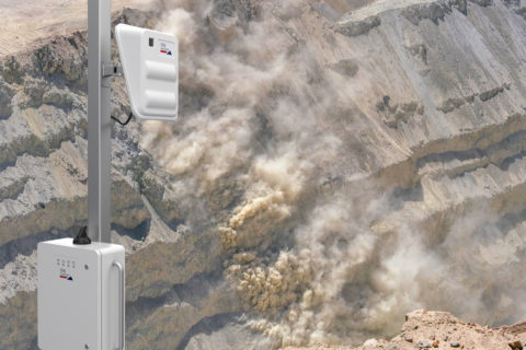
Reutech ups slope monitoring scanning speeds with MSRIV Esprit

Reutech Mining says it has launched the fastest scanning and most sophisticated slope monitoring radar in the industry, the MSRIV Esprit.

“The exceptional high scan speed ensures early detection of developing slope failures at mines, and enables accurate movement detections of fast-moving slopes rapidly changing atmospheric conditions,” Reutech said.

Esprit uses the latest core radar technologies to increase the safety reaction time between first warning and the possible event of a slope failure, Reutech says, contributing to the confidence of mining operations continuing in a safer, monitored environment.

Reutech Mining Executive, Jan de Beer, said: “At Reutech Mining, we are constantly striving to design and produce the most effective slope monitoring solutions with radar. It has proven to minimise risk in daily operations, is critical to mining planning and increases productivity.

“Nothing satisfies us more than providing the best possible data with the least interruption to daily operations and we are certain that the fourth generation MSR will do exactly that.”

Neville Greyling, Product Manager, explains: “With the MSRIV Esprit’s exceptional scan time of less than two seconds for an entire area covering more than 22 million m² at an operating range of 4,000 m, we ensure that virtually no noise is introduced. Due to the fact that an entire area is measured instantaneously, we can provide the truest, up-to-date slope data.”

“Coupling instantaneous 3D area measurements with the fast scan speed ensures that, when doing critical monitoring, slope velocities of up to 13,500 mm/h can be attained – the best in the market,” the company said, adding that during strategic monitoring, smaller movements are detected with greater accuracy.

Greyling said: “This means predicting potential failures earlier and increasing warning times. It will result in overall safer open-pit mines in areas prone to fast moving slopes and with rapidly changing atmospheric conditions.”

Hexagon to fill the rockfall monitoring void with IDS GeoRadar RockSpot

Hexagon AB has announced the launch of IDS GeoRadar RockSpot, a radar system that fills a gap in the monitoring of natural and engineered slopes.

The system detects, tracks, and analyses the slightest movements from rockfalls, avalanches, and other fast-moving landslide debris flow, according to the company.

“RockSpot creates real-time alerts that can be connected to on-site alarms (eg sirens, automatic road closures or other alert devices). Georeferenced, recorded event data provides advanced statistics and analytics for risk assessment and vulnerability zone mapping, the company said.

Ola Rollén, Hexagon President and CEO, said Hexagon is committed to empowering customers to put data to work and, in the case of RockSpot, “they’re able to leverage data to protect workers and the general public in high-risk areas of potentially catastrophic events”.

He added: “This intelligent safety solution, designed to withstand all weather conditions, continuously monitors day and night.”

RockSpot can identify rockfalls up to 2 km from the slope, as well as avalanches and other fast-moving events, like mudflow and debris flow, up to 4 km from the slope.

With a coverage field of 40° vertical and 80°horizontal, the system can consistently monitor an entire mine wall or natural slope at high resolution with a single radar unit, according to the company.

Hexagon said: “RockSpot’s alerts can be customised sector by sector using advanced algorithms that distinguish rock movements from other moving objects, such as haul trucks, animals and people.”

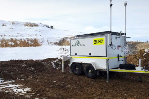
Maptek equips Sentry stability monitoring system for the cold

Software, hardware and services provider, Maptek, has released a cold climate model of its award-winning mobile Sentry system for stability monitoring, as it looks to expand its market reach even further.

Sentry is a mobile remote monitoring system that uses laser scanning to continuously measure ground movement with extremely fine spatial resolution and accuracy, according to Maptek. Housed in a self-contained unit with autonomous power and communications capabilities, Sentry relies on software to monitor, analyse and report in real-time.

The newcomer to the Maptek technology portfolio answers the imperative for continuous, reliable measurements of ground movement no matter the environment, Maptek said.

Maptek Product Manager, James Howarth, said: “Risk management remains a priority. If anything, the reliable operation of technical equipment is even more critical in extreme conditions.

“Climate factors play an important role in the execution of any mining project. Extremely low temperature conditions require considerable planning and logistics, especially from an operator safety perspective.”

The Sentry system can operate continuously from -20°C to +50°C, with operation for a limited time in temperatures below -20°C. It requires an XR3 cold climate laser scanner, which has been redesigned and tested to operate at these low temperatures, Maptek said. A removable neoprene jacket for the scanner provides extra protection against wind chill.

Maptek redesigned all the major components in the standard temperature Sentry mobile system, with significant changes to achieve the required cold climate specifications, it said.

The company said: “In deep cold weather, the charge acceptance of batteries is very low. Keeping batteries warm maximises power output and ability to accept a charge. The battery pack and housing in the Sentry system has been redesigned and insulated to keep the unit at a stable operating temperature. Other built-ins such as generator, hydraulics and electrical systems were adapted to maintain energy efficient, cost-effective operation.”

Howarth added: “What hasn’t changed is the proven capability to monitor multiple areas. Customers enthuse on how easy Sentry is to set up and use. Data is displayed intuitively, ready for immediate application in risk management programs.”

The 3D point cloud data that has been collected while monitoring can be used for geotechnical analysis and other applications. The Maptek laser scanner can also be redeployed from the monitoring for routine survey tasks.

Geobrugg slope stability system ups protection ante at Alrosa’s Aykhal diamond mine

Geobrugg has recently installed nails, mesh and spike plates as part of a slope stabilisation system at Alrosa’s Aykhal diamond operation in Mirninskiy Ulus, Russia.

Aykhal is in the permafrost region of Russia, a fact that comes with hazards – for two to three months of the year, rockfalls can occur as a result of melting permafrost. This makes it difficult and, potentially, dangerous for the trucks and operators that come in and out of the underground mine portal and navigate around the former open-pit mine site.

Some conventional wire mesh was widely used at the operation, until now, to safeguard the portal, according to Geobrugg. “As this mesh did not provide enough safety and has to be changed every two-to-three years, Alrosa decided to test Geobrugg state-of-the-art technology,” the company said.

For the protection solution, Geobrugg’s TITAN 40/16 nails with TECCO® G65/3 mesh and P33/50 spike plates were employed. In total, an area of 1,400 m² of mainly fractured dolomite with an unstable layer from 1.1-1.5 m was stabilised, according to Geobrugg. The installation on a 70-85º slope took one month and a Geobrugg Supercoating® was employed for corrosion protection, the company said.

Geobrugg said: “One of the challenges was the delivery of material and drilling machinery to the site: In winter time, you may use the ice road which runs along the river Lena. In the summer, material has to be delivered by ship, which takes one-and-a-half months from the European part of Russia to this site.”

Installation had to be carried out during the short period when temperatures were above freezing – mid-May to mid-September – Geobrugg said.

GroundProbe brings new features and functionality to SSR-Viewer 9

GroundProbe has released a new version of its SSR-Viewer software that comes with a powerful engine to “revolutionise” 3D data visualisation across its entire suite of Slope Stability Radars and lasers, according to the company.

CEO John Beevers said the release brings a host of new features and functionality to its “market-leading platform, many of them developed in collaboration with our customers”.

The SSR-Viewer 9 release features two new analysis tools, the possibility of visualising 2D radar data in 3D, drag and drop external layers and structures, and alarm threshold visualisation, among other developments.

The latest release supports all GroundProbe Series-2 and Series-3 radar technologies – 3D real aperture radar, 2D real aperture radar and 2D synthetic aperture radar – and both of the company’s new LiDAR-based technologies, the Geotech Monitoring Station (GMS) and Geotech Monitoring LiDAR (GML).

“All the features and benefits of SSR-Viewer that our long-serving radar customers have been accustomed to – such as its intuitive visualisations, industry-leading analysis tools and powerful reporting – are now also available for our LiDAR-based solutions,” GroundProbe said.

The 2D radar data visualisation in 3D allows SSR-FX and SSR-SARx users to view data in the new DTM (digital terrain map) View visualisation, as well as in the existing Plan View visualisation.

“In both, the deformation heatmap is overlayed on top of the scene, and users can switch between the two visualisations. To visualise the 2D data in 3D, users simply import their mine site DTM and align the radar data with it,” GroundProbe said.

“The two are snapped together ready for viewing and analysis. Once the DTM is imported, the radar data is automatically geo-referenced.”

For SSR-XT users, the 3D visualisation functionality has been “significantly improved”, the company said.

“The radar still automatically generates a powerful, high-density 3D model of the wall, live, with every scan. But SSR-XT users now have the flexibility of optionally importing a mine DTM for a holistic view of the entire site.

“Across all our radars, the new DTM feature also allows users to drag and drop external models, geology layers and structures, with geo-referencing built in. Data layers, such as the data point cloud, radar point cloud and enhanced deformation masks can be switched on and off to suit the user.”

The two new analysis tools are called Forecast and Spot Velocity.

Forecast allows users to estimate the time of collapse using inverse velocity theory, with users able to add a forecast prediction, in-chart, to easily visualise when the plot reaches zero and, hence, the time of collapse.

Spot Velocity, meanwhile, gives users the rate of change between two points in time with the click of a button. It gives the user not only the rate of change, but also the delta time and delta measurements.

And, the alarm threshold visualisation tool – available for all alarm types – comes on a ‘banded window’ on the corresponding analysis chart. When an alarm is defined, the threshold is visualised in the charts using a banded window of three colours.

“Green areas show when an alarm isn’t triggering, while the red and orange areas highlight when the alarm will trigger, allowing for an early indication of when an alarm is approaching,” the company said.

Alarm thresholds are also a powerful back analysis tool, GroundProbe says. Site specific alarm thresholds can be generated from back analysis and an iterative approach towards the application of alarms can be adopted.

SSR-Viewer 9 also has the option of a single or double view on SSR-XT, GMS and GML devices, and increased levels of support with WebUpload.