Tag Archives: Surpac

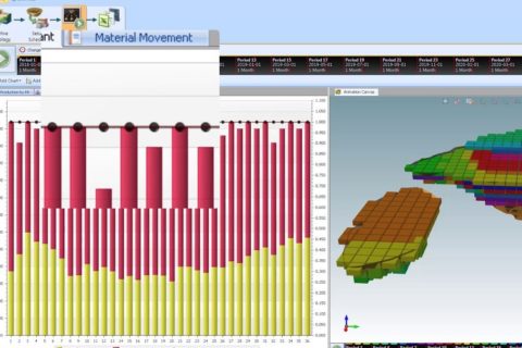
GEOVIA MineSched 2020 receives the 3DEXPERIENCE

The new GEOVIA MineSched 2020 comes with the ability to publish results to the 3DEXPERIENCE platform with MineSched POWER’BY, and allows users to update the starting point of all development and production activities for underground workflows and more, according to GEOVIA.

The results of a MineSched schedule can be uploaded to the 3DEXPERIENCE platform to analyse and share schedule data, the company, owned by Dassault Systèmes, said.

“With report authoring and analytics, users can gain insights and knowledge about the tactical schedule,” GEOVIA said. “More importantly, with dash-boarding and collaboration, you can share those insights and knowledge with other stakeholders.”

Users can quickly and easily update the starting position of the schedule based on survey results and development reports with the new Development Progress Tracking tab, as well.

Mining Locations, created as part of the Surpac Stope Shape Optimizer (SSO), can now be directly imported into MineSched via the SDM Model process. To enable this workflow, a new Locations type option has been added to the Location Grouping workflow, and the option to select Stopes is available.

In addition a schedule can be quickly and easily updated based on survey results and production reports with the new Production Progress Tracking.

Additional enhancements or defect fixes that improve work performance include changes to Location names in Spreadsheet View; changes to Material Movement rules while performing stockpile blending calculations; performance improvements while using the Evaluate Headings process; and replacement of the Spreadsheet tools with a more modern solution.

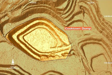
LiDAR proves up potential new resource at Kingston’s Misima gold project

A recent LiDAR survey has confirmed the location of a large stockpile of mineralised material at Kingston Resources’ Misima gold project in Papua New Guinea.

The light detection and ranging (LiDAR) survey provided a highly accurate and detailed model of the surface terrain, which has assisted in identifying historical mining topography, current and historic artisanal mining, as well as identifying potential geological features and determining water drainage patterns, Kingston said.

This near-surface stockpile is not accounted for in the current 2.8 Moz indicated and inferred gold resource at Misima, according to the company.

“This information will assist and enhance the broader drilling and exploration programme,” Kingston said. “A stockpile of mineralised material left in place by former owner Placer Dome (since acquired by Barrick Gold) has been confirmed at the Cooktown Dump, a large area adjacent to the Tonowak Pit reported to contain 3.6 Mt of low-grade material averaging 0.5 g/t to 0.7 g/t Au.”

This dump, which was capped with topsoil and rehabilitated during the closure process, remains intact, with its current position matched against mine survey files created during mine closure, according to Kingston.

“While the grade of the Cooktown Dump is modest, it is important to note that it represents loose rock, at surface and close to the likely location of a future processing plant,” Kingston said. “All of these factors reduce mining and processing costs.”

By calculating the volume of the Cooktown Dump LiDAR model and cross-referencing this against Placer’s Mine Closure Plan and survey files from 2000 to 2004, the company has set an exploration target for the dump of 3.6 Mt at 0.5 g/t to 0.7 g/t Au for 58,000-81,000 oz of gold.

The company’s exploration strategy is now firmly focused on discovering and defining near-surface satellite mineralisation at prospects including Ginamwamwa, Quartz Mountain, and Ara Creek.

“Adding near-surface resources is likely to enhance the economic potential of any possible future mining operation. The close proximity and minimal mining costs of this stockpile make it an excellent early feed source to any future development plan,” Kingston said.

The tonnage figure of 3.6 Mt is taken from information and tables within the Misima Mine Closure Plan published in 2000. To check this, a digital model of the Cooktown Dump was created from the LiDAR data using Surpac software, assuming the dump was constructed on a flat surface as described in the closure report. The volume within this model is 2.44 million cu.m.

Using a bulk density range of 1.8 to 2.0 t/m3, this equates to approximately 4.4 Mt to 4.9 Mt. After taking into account the fact the dump is covered with a layer of topsoil capping, the current dimensions agree closely with the reported tonnage. The dump dimensions have also been checked against mine survey records from 2002 and 2004, both taken during the mine closure process, and the survey records match the 2018 LiDAR topography. As a result of these validation checks against the original report, the company has chosen to express the exploration target tonnage as 3.6 Mt rather than an indicative range.

Kingston Resources currently has an earn-in agreement for Misima where it can receive a 70% stake in the project by completing a stated amount of exploration work.