Tag Archives: surveying

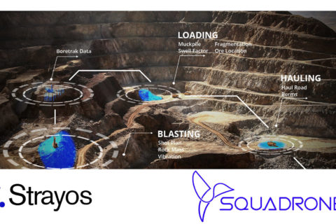
Strayos, Squadrone combine AI and drone mapping nous to optimise Indian mining sector

US-based Strayos and India-based Squadrone have announced a new partnership that will combine mine-to-mill artificial intelligence-based solutions with drone surveying to “bring futuristic mines to more sites in India”, Strayos CEO, Ravi Sahu, says.

Squadrone bills itself as being one of the most progressive companies in the application of aerial intelligence in the mining industry in India, providing tailor-made UAV solutions for various applications from mining to drilling & blasting to disaster management. It provides drone mapping, surveying and site digitalisation services to its clients to efficiently manage their site’s day-to-day operations in mining, it says.

Strayos is an AI-based company that uses data from a diverse range of smart tools, edge devices and sensors, including drones, to create 3D digital models of sites. Site digitalisation is further enhanced by Strayos’ end-to-end site AI tools that analyse data from various sources to shape safe and immediately usable key insights, automation and accurate predictions, it says.

This collaboration will pave the way for novel holistic site-level insights, according to the companies. Along with the digital 3D site model created from drone data, users can now leverage Strayos’ Geology Detection AI, Drill & Blast AI and Site Analytics AI, with inventory management. With the addition of these tools, mining stakeholders across numerous site operations will be able to pool and access data from the entire operation, according to the companies.

For instance, blasting engineers will have access to geological data when designing blasts, drillers will be able to accurately predict how their drilling affects the mill’s performance and mine engineers will be able to plan site design with precision based on up-to-date geology and optimised drilling & blasting to reduce load and haul costs.

Brad Gyngell, COO, Strayos, said: “Mining in India is going through a major transformation presently, with drones and AI being the perfect tools to accelerate these advancements. We couldn’t be more excited to collaborate with Squadrone and deliver superior solutions to our customers in India.”

Cyriac Joseph, CEO, Squadrone, Bangalore, India, said: “We pride ourselves on being able to provide the mining industry with the best services and the best products in open-pit mining, drilling and blasting, rock mechanics, mine safety and underground mining. Our boots on the ground and Strayos’ cloud-based Al tools will greatly benefit the Indian mining industry with these specialised applications to facilitate amazing analytics with visual intelligence through drone technology.”

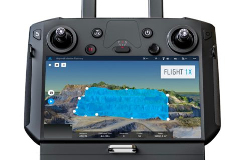
Skycatch maps out autonomous mining future with DJI M300 mapping, analytics solution

San Francisco-based Skycatch has been making waves in the drone space with a range of mapping solutions tailored for mining applications but, according to Chief Technology Officer, David Chen, it thinks of itself as a “software-first company”.

He explained to IM: “We are really a computer vision company, and we focus on building not only the drone solution, but the software that enables it.”

This sees the company provide data capture automation, processing, visualisation and analysis tools to the industry for efficient decision making.

Chen added: “We work with a number of the top mining companies across the globe, providing them with unique solutions that they are using every day to complement their existing survey processes.”

The company, which has become a leader in highwall mapping through these solutions, is expanding beyond surveys into other areas.

This will be facilitated through software like its Flight1X, a cloud-based solution designed specifically for the recently launched DJI M300 drone that, Skycatch says, delivers unprecedented drone mapping accuracy and inspection automation for operations like mines. The proprietary software offers the most complete end-to-end high precision industrial drone capabilities available today, according to the company.

Flight1X, launched at MINExpo 2021 today, comes with proven data and network security via Skycatch servers in the USA, with the Android-based flight planning application running on the M300 Smart Controller. When combined with Datahub, Skycatch’s cloud-based solution, the pair offer mission planning and data visualisation.

Chen expanded on some of these capabilities.

“The majority of drone software out there has been focused on 2D mapping, whereas we have seen that mining, which comes with dynamic and undulating terrain, requires something different.

“What we are building is an automated mission planner where the primary view is of 3D terrain. This planner allows you to bring in existing terrain data from elsewhere or capture and process data from our own platform. The user can then rotate around this map and see the exact mission profile in 3D for improved visualisation and decision making.”

This data integration piece, which hinges on the cloud-based Flight1X platform, could provide Skycatch with an ‘in’ to the tailings dam monitoring market.

“While we’re already providing some survey solutions for tailings dams, the combination of high precision survey (with cm-level precision) for dam movements, fully automated section missions based on RGB and thermal imaging, and machine learning could provide data on dam seepage, for instance,” Chen said.

“We also want to integrate IoT sensors around dam movement and other areas into this cloud-based platform to provide an overall view of the tailings management facility.”

Skycatch is currently working on integrating the DJI M300 and L1 & P1 sensors – purpose built for mapping and surveying – into its offering, with Chen seeing the process as just the next stage in facilitating the autonomous mine of the future.

“The one thing that fully autonomous mines need is a map of the mine for these autonomous machines to operate off,” he said. “We have a focus on making data more accurate, accessible and faster; making it faster is the key for fully autonomous mining.

“Right now, with the current photogrammetry process, it’s still: capture, process and wait a few hours for a map. To be fully autonomous, you need that dynamic map in near real time, which is what we can offer the industry.”

Trimble expands surveying, 3D modelling capabilities with SX12 Scanning Total Station

Trimble has introduced the Trimble® SX12 Scanning Total Station, the next iteration of its 3D scanning total station that, it says, provides fast and efficient data capture for surveying, engineering and geospatial professionals.

New features, including a high-power laser pointer and high-resolution camera system, expand capabilities in surveying and complex 3D modelling, and enable new workflows in tunnelling and underground mining, according to the company.

The Trimble SX12 merges high-speed 3D laser scanning, Trimble VISION™ imaging technology and high-accuracy total station measurements into familiar field and office workflows for surveyors, the company says. A new green, focusable Class 1M laser pointer is safe for viewing with the naked eye, offers high-power visibility and makes it easy to see even at a distance. Meanwhile, an improved camera system provides enhanced pointing and site documentation capabilities.

Gregory Lepere, Marketing Director of Optical and Imaging for Trimble Geospatial, said: “The new SX12 adds more features and applications to an already widely adopted, field-proven scanning total station. The addition of a premium laser pointer completes the picture for surveyors wanting an instrument that can operate as an everyday high-end total station with the added value of scanning and imagery.”

The Trimble SX12 allows users to operate with common survey workflows, including new versions of Trimble’s field and office software.

“With Trimble Access™ 2021 Field Software, users can harness the full potential of the Trimble SX12, whether performing accurate measurements or comparing 3D scanning as-built data in the field,” it said.

“With the laser pointer, it also enables new applications for laser-guided drilling and excavation guidance, rock bolt and blast hole set out, and as-built verification for underground tunnel and mine construction.”

By integrating rich data from the Trimble SX12 into intuitive office workflows, Trimble Business Center version 5.40 enables users to quickly create complete customer deliverables. With its enhanced point cloud management, eCogAI™ automated information extraction, and interoperability to leading CAD and GIS packages, the solution empowers users to exceed even the toughest client demands, it said.

“The combination also enables the capture of rich tunnel point clouds for as-built comparison, automated tunnel extraction routines and detailed 3D mesh inspection resulting in intuitive reporting deliverables for construction verification,” the company added.

Boris Skopljak, Marketing Director of Monitoring and Tunnelling for Trimble Geospatial, explained: “Tunnelling projects are highly dependent on accurate positioning to precisely control equipment and track progress in difficult underground construction environments. The combination of the SX12 and new software workflows simplifies the capture of site conditions, enabling tunnelling and mining surveyors to make accurate and informed decisions without the complexity and additional cost of multiple systems.”