Tag Archives: surveys

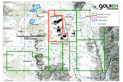
Delta Drone to perform virtual 3D model baseline survey for GoviEx at Madaouela

Delta Drone International is set to enter the Niger market for the first time after being contracted by uranium explorer and developer, GoviEx Uranium, to perform a virtual 3D model baseline survey for GoviEx’s Madaouela project.

The baseline survey will be one of the first times Delta Drone International uses its advanced surveying and data capture technology to create a shareable view of a potential mining site to share with GoviEx Uranium stakeholders, it said. These stakeholders are currently unable to attend the site due to current travel restrictions, while the engineering teams will use the results for project construction design.

Over a two-week period, Delta Drone International’s specialist mining pilots will deploy state-of-the-art surveying drones, with the data captured to be used by GoviEx Uranium as the base to build a virtual 3D model of the new site and consult with key international stakeholders, virtually, it said.

Delta Drone International CEO, Christopher Clark, said: “This is the first time Delta Drone International has been commissioned for a project in Niger – a region where aviation, including drone operation, requires military clearance. This project with GoviEx Uranium is an example of the many ways drones are being used to more efficiently share the data needed to guide decision making among business leaders.”

He added: “Working with the GoviEx Uranium team right from the planning phase of their new mine ensures we can seamlessly collate multiple data sets of areas where low-quality, outdated or even no data is available, export it into easy-to-utilise formats and virtually share with their international stakeholders – removing the need for on-site attendance. This type of data capture is likely to be increasingly used in remote sites to support much more efficient and timely stakeholder engagement and decision making around key milestones in projects.”

An updated prefeasibility study from February on Madaouela, based on probable mineral reserves of 54.7 Mlb of U3O8, indicated the company could build a 1 Mt/y operation able to produce 2.48 MIb of U3O8 for 20 years from mostly open-pit reserves.

Delta Drone to fly UAV-based LiDAR units at Newmont’s Ahafo gold mine

Global drones-as-a-service provider Delta Drone International says it has been re-appointed by Newmont Ghana Gold Ltd, a subsidiary Newmont in Ghana, for a light detection and ranging (LiDAR) project on its Ahafo mine.

Delta Drone International will provide a drone-based LiDAR solution to create an accurate 3D model of the earth and its surface characteristics to map new areas for the mine and mitigate potential risks prior to mine expansion construction commencing, the company says.

Delta Drone International CEO, Christopher Clark, said: “To continue working with Newmont Corporation, one of the world’s leading enterprise gold mining companies, who is using advanced drone techniques for several types of project applications, is a testament to our specialist expertise and drones-as-a-service model.”

He added: “Using the latest in drone LiDAR technology, we can fly with this sensor in a fixed-wing drone, allowing us to map new areas and essentially compete with manned LiDAR, but at a lower price point.

“We are seeing increased demand to use our LiDAR capability to create ‘digital elevation models’ that allows companies to see below thick forest and other surface vegetation and more accurately determine site suitability for certain types of infrastructure and how a site can be used.”

Inmarsat, AST and Harvest team up to connect remote maintenance, service teams

A new agreement between Inmarsat, Harvest Technology Group and Inmarsat Partner, AST, will provide Harvest’s customers across the mining, energy and utilities sectors with the tools to remotely monitor assets, coordinate site surveys and conduct maintenance operations over real-time video and audio transmitted via ultra-low-bandwidth satellite communications, Inmarsat says.

These sectors are facing increasing pressure to maintain vital infrastructure and equipment while safeguarding workers, all in the most cost-effective way possible, the company says. With global travel restrictions and sustainability challenges now impacting many organisations, pressure is also mounting to allow personnel in remote locations to be connected live back to base, the office or home to enable simultaneous review and decision making worldwide.

“The alliance will bring greater functionality to Harvest’s ‘data-anywhere’ solutions, which can transmit high-quality synchronised video and audio across an extremely low bandwidth,” Inmarsat says. “Harvest’s popular Wearwolf™ wearable headset solution enables remote workers to communicate directly with technicians, engineers and site managers who may be located across different continents simultaneously in real time, from the comfort of their offices or homes, so removing the need to travel.”

From a connectivity standpoint, the Wearwolf solution allows high-data-rate streaming of video and audio over satellite by wirelessly connecting to Inmarsat’s Explorer 710 BGAN (Broadband Global Area Network) terminal.

“Our global connectivity services are underpinned by the world’s most reliable satellite communications network, which is the backbone for maritime, aviation and land safety services throughout the world,” Inmarsat says. “This ensures that any type of survey, inspection or maintenance procedure can be experienced through the eyes and ears of the crews on the ground and directed by technicians and engineers as if they were on site, from anywhere in the world.”

Steven Tompkins, Director of Sector Development at Inmarsat, said: “The energy, utilities and mining sectors have all harnessed the benefits of global satellite communications to maintain safe and efficient operations for a number of years. However, these challenges have been exacerbated by global restrictions imposed as a result of the coronavirus pandemic, which means that there has never been a greater need for affordable solutions that help organisations collaborate, work together and improve operations, no matter where they are located.

“By developing a wearable solution that supports our High Data Rate streaming capabilities across a low-bandwidth connection, Harvest is facilitating highly efficient, safe, cost-effective and sustainable site surveys of pipelines and valuable assets across industrial sites in remote areas around the world. We are excited about the huge potential of this agreement and how it will change the way industrial professionals communicate and collaborate, no matter where they are located.”

Gregory Darling, Managing Director of AST, added: “AST is delighted to partner with Harvest and Inmarsat to provide real-time video and audio solutions cost effectively through our secure global INTEGRA network from anywhere in the world. The alliance supports our vision to continuously empower our customers with dependable solutions that improve their operational efficiency, reduce their health and safety risk and minimise their carbon footprint.”

Harvest’s Managing Director, Paul Guilfoyle, said the alliance will not only allow for the implementation of existing technology, but will further “fuel the innovation for future cutting-edge communication initiatives”.