Tag Archives: tailings monitoring

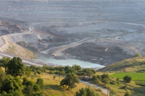
Davra and IoTDC to pair expertise for enhanced tailings storage facility monitoring

Industrial IoT solutions providers Davra and IoTDC have announced what they say is a landmark partnership that merges their expertise to launch a state-of-the-art suite of software applications for the comprehensive safety monitoring of mining operations.

The announcement was made during the recent visit of the Irish Tánaiste (Deputy Prime Minister), Micheál Martin, to Wits University in Johannesburg.

This initiative builds on Davra’s established collaboration with the European Space Agency (ESA) on the Protelum project, ensuring stringent compliance with the Global Industry Standard on Tailings Management (GISTM).

The advanced software suite focuses on real-time monitoring and management of tailings storage facilities (TSFs). By harnessing the power of advanced sensors, predictive analytics, machine learning algorithms, and Earth Observation (EO) data from the European Copernicus program and other sources, the software provides early detection of irregularities and potential hazards, thereby enhancing the safety and operational efficiency of mining enterprises, the companies say.

Additionally, the suite ensures full GISTM compliance, helping mining operators align with the highest international standards for tailings management safety and integrity, they claim.

Key features and benefits include:

  • Real-time tailings monitoring: the software suite employs EO data from the Sentinel satellite constellation and IoT sensors to provide real-time insights into tailings dam stability, enabling swift detection and response to potential issues;
  • Predictive analytics and machine learning: utilising the capabilities of AI, the software predicts and prevents potential incidents by analysing behavioural trends and patterns in tailing dam operations;
  • GISTM compliance: the suite assists mining operations in achieving rigorous GISTM compliance, ensuring the utmost safety and integrity in tailings management; and
  • Enhanced operational efficiency: with continuous monitoring and AI-powered analytics, mining operations can significantly improve productivity, reduce downtime and minimise environmental impact.

“We are thrilled to announce this partnership with IoTDC during the Irish Tánaiste’s visit to Wits University,” Paul Glynn, CEO of Davra, said. “By combining our ongoing engagement with ESA on the Protelum project and our cutting-edge IoT technology, we’re equipping mining operators throughout South Africa with an unparalleled tool to manage and monitor their tailings storage facilities.”

Ewald Fourie, CEO of IoTDC, added: “This collaboration with Davra brings together our local mining sector expertise and their global IoT and space data experience to deliver a unique solution. We’re confident that this technology will set a new standard for safety and sustainability in the mining sector.”

ASTERRA’s EarthWorks monitoring solution successfully leveraged at tailings dam in Europe

ASTERRA says its EarthWorks solution has been successfully used as a tailings dam monitoring tool by a leading mining company in the Nordic region of Europe.

The mining company’s goal is to create an accident-free and healthy operation characterised by safety and wellbeing. It is, therefore, constantly implementing new technologies and innovations to ensure sustainable work environments.

Eddy Segal, VP for Sales and Business Development at ASTERRA, said: “Forward-thinking companies are always looking for technologies that can improve performance and safety. We are thrilled the EarthWorks solution, which in this case was used for tailings dams monitoring, was adopted in Europe.”

This use of ASTERRA’s EarthWorks solution supports the United Nations Global Industry Standard on Tailings Management, reduces the negative environmental impact caused by mining and has a positive climate influence, ASTERRA said.

EarthWorks is a solution that provides efficient and improved satellite-based surveillance of critical infrastructure. It is used to monitor the area near large installations, seeing through pavement and treetops, uninhibited by light and weather conditions. The technology yields data revealing the actual underground soil moisture that increases the risk of failure or catastrophe. Numerous industries are now served by EarthWorks, including dams, levees, roads, rail, mining and property.

Segal added: “Using Earth observation satellites to inspect critical assets will improve staff safety as more work gets done off-site. In this specific case, sub-surface moisture mapping can alert maintainers to a dam’s internal erosion a long time before any signs appear on the surface.”

Synspective and Insight Terra team up to address potential mine-related disasters

Synspective, a Tokyo-based synthetic aperture radar (SAR) satellite data and solutions provider, and Insight Terra, a London-based start-up providing a cloud based environmental and infrastructure risk management platform and solutions, have entered into a strategic partnership to deliver a new space-enabled data and monitoring solution for the mining industry.

The solution uses satellites and earth observation coupled with ground sensors to monitor mine tailings facilities.

Synspective and Insight Terra will work together to provide an integrated product offering combining Insight Terra’s cloud-based IoT Insight Platform with Synspective’s leading-edge analytical models of SAR data for the mining and other related industries. The integrated solution allows for the fusion of near real-time ground truth and earth observation data for proactive monitoring and alerting, the companies said.

Insight Terra’s Tailings Insight is currently deployed with a number of global mining companies for tailings dam monitoring.

Synspective develops and operates high-frequency, high-resolution SAR satellites called “StriX” to provide high-quality data sets and solution services. The company has already placed three satellites into targeted orbit while planning to establish the constellation of 30 satellites and an analytics platform by late 2020s.

”The integration of SAR data gathered by Synspective’s growing constellation of StriX series satellites will provide powerful earth observation capabilities to the Tailings Insight application,” they said. “This cutting-edge technology can be utilised to monitor ground movement and land deformation that are risk indicators for potential failures of tailings facilities, mine walls and water dams, among others.”

The companies will initially focus on the global mining industry, saying the Tailings Insight solution including new InSAR capabilities will be a leap forward for mining operators, investors and regulators seeking to monitor and mitigate potential mine-related disasters affecting people, communities and the environment.

The combined solution is, the companies say, aligned with the Global Industry Standard on Tailings Management (GISTM) promulgated in 2020 by the International Council on Mining and Metals, the United Nations Environmental Program and Principles for Responsible Investment. The GISTM requires mines with high-risk tailings facilities, both active and closed, to comply by August 2023.

Exyn’s drone-based mining autonomy ambitions taking flight

Having already achieved the highest documented level of aerial autonomy – level 4A – with its drone-based solutions, Exyn Technologies is striving for further industry firsts, Raffi Jabrayan, VP of Business Development and Commercial Sales, says.

One of its more recent breakthroughs came in Germany at the K+S’ Werra mine site, where a team demonstrated the use of the ExynAero™ and ExynPak™ at an underground salt mine.

Over the course of three days underground, Exyn’s field engineers successfully flew multiple autonomous missions in hard-to-reach areas while capturing rich, high-fidelity point clouds in a fraction of the time it would take traditional cavity monitoring systems, according to the company.

Jabrayan explained: “Several drone companies had previously attempted an autonomous mission to scan the immense cavities this specific site has, but the dust interference meant most of these missions ended within seconds.

“We were able to fly in some cavities completely beyond visual line of sight, mapping areas in a fraction of the time the teams would normally take for such manual inspections. In all, we were able to carry out a six-minute autonomous flight at the site.”

While the company did not carry out any specific modifications to its ExynAero platform to conduct such a flight, Jabrayan acknowledged that ongoing design and software improvements over the last year had enabled the company to accurately detect both dust and thin wires underground.

In addition to this, the company also displayed the capabilities of its handheld ExynPak solutions while on site in Germany.

The ExynPak, according to Exyn, can provide the world’s first real-time colourised point cloud visualisation on a handheld LIDAR scanner, capturing precise, colourised 3D models 20-30 times faster than a traditional stationery tripod or terrestrial scanner.

Powered by ExynAI™, the ExynPak ‘drapes’ real-time RGB information captured through two hemispherical fixed cameras onto point clouds created by a gimballed Velodyne LIDAR Puck LITE, providing operators a complete colourised 360° view of their environment, Exyn says.

At the Werra mine site, the Exyn team was able to capture a colourised cloud where the stratification of the rock could be clearly seen in the scan, enabling the K+S team to obtain data it would likely never be able to replicate in any other way, according to the company.

Jabrayan says such information could see operators plan their mining processes around the colourised captures, following mineralisation identified by the scans to ensure no economic ore had been missed after mucking out.

At the Werra mine site, Exyn’s field engineers successfully flew multiple autonomous missions in hard-to-reach areas while capturing rich, high-fidelity point clouds in a fraction of the time it would take traditional cavity monitoring systems


The ExynPak is likely to become a core part of Exyn’s next aerial autonomy offering for open-pit mining, powered by ExynAI, which enables safe flight in the most dangerous industrial environments.

“We have done some work in terms of moving our flights to the surface,” Jabrayan said. “It could cover various aspects – tailings monitoring, highwall scans…there are lots of requirements for it. We are actively working on integrating GPS into our ExynAI stack for outdoor autonomous flights, however, it’s not ready to be pushed to customers just yet.”

The company is currently working on surveys of ground-based resources, such as stockpiles, using a handheld ExynPak, plus carrying out aerial flights in manual mode.

Reaching the level of autonomy it has underground will most likely involve the help of its collaboration partner, EY, and a third company providing “software and visualisation input”, Jabrayan says, adding that he expects to see this autonomous solution come to light in 2023.

Earlier this year, Exyn, in partnership with Maestro Digital Mine, presented an aerial drone fitted with a Maestro gas monitoring Industrial Internet of Things (IIoT) device.

This new gas monitoring drone, which integrates critical gas sensors onto the ExynAero and ExynPak platforms, is effectively the “quickest and safest mobile gas monitor on the planet”, Michael Gribbons, CEO and Co-founder for Maestro, said.

Powered by ExynAI’s multi-sensor fusion capabilities, gas sensor readings are captured while the robot is in flight and displayed in real time via a ruggedised tablet, Exyn explained. These sensor readings are saved with precise coordinates in a high-fidelity point cloud that can be exported and examined in a variety of mining software.

Jabrayan says a lot of mines have reached out to the companies since first presenting the solution at the SME MineXchange Annual Conference & Expo in Salt Lake City, earlier this year.

“They are interested in the benefits such a solution could provide in terms of safety and productivity,” he said. “By flying the gas sensing drone underground soon after a blast, it could take the necessary readings and issue a notice to another system that it is safe to re-enter the area.”

This could see more mines shift away from re-entry processes based on out-of-date manual gas readings, to a system that is much more accurate and shaves – potentially – hours off operational downtime.

Exyn is closing in on a long-term trial agreement with at least one miner in Australia looking to test out this gas-sensing drone solution, according to Jabrayan.

“The long-term plan is to develop a drone-in-a-box solution that can reside underground and be flown immediately after a blast to offer the quickest possible readings,” he said. “Remote autonomous mapping of this type could see Exyn provide data to shift operators as they are heading underground, allowing them to get a picture of the environment ahead of reaching the location.”

The incorporation of such data into mine site operational processes could see drone-based solutions become vital to the running of mines in the future, and Exyn, through its post-processing pipeline, ExSLAM, is looking to enable this.

ExSLAM extracts the raw cloud from robot logs and refines it for third-party software, using a factor graph optimisation algorithm to create low-drift point cloud maps.

Jabrayan says the company continually receives plaudits from customers about the ease of use of this solution, explaining that Exyn is one of the few companies that georeferences its maps inside an existing coordinate frame.

“From there, we are able to detect all the survey points, download them, georeference them and push the data to any end-user software,” he said.

Exyn, Jabrayan says, is software agnostic when it comes to this process, but he did admit the company was in advanced talks with some leading mining software companies that could see its mapping data integrated directly into their platforms.

“We are also working with certain companies to use robotic process automation to make it a one-button process to scan, go directly into the end-user software, and create a mesh that can be used,” he said.

“We remain focused on using our technology and R&D to provide the best solution to customers in order for them to be as productive as possible and, of course, work in a more efficient and safe manner.”

Tailings monitoring could go autonomous, Mining3 says

Mining3 says it and The University of Queensland, in conjunction with the Australian Coal Association Research Program (ACARP), are currently in the process of building prototype autonomous sensors for the constant monitoring of tailings and spoil storage facilities.

The Australia-based company said: “Tailings impoundments are one of the largest man-made structures on earth and ensuring their integrity for the safety of human life, the environment and property are critical in today’s mining operations. Past and recent catastrophic tailings dam failures have placed an urgent need for improved waste disposal, storage processes and monitoring capabilities.”

Currently, the integrity of the tailings dam infrastructure is monitored by mining staff walking along the, potentially unstable, perimeter and visually inspecting the exterior. Piezometer-like devices are also placed throughout dams to measure changes in liquid pressure. “Combined, these methods provide subjective data that cannot deliver an ongoing and accurate assessment of the integrity of these waste storage facilities,” Mining3 said. “Without a reasonable assessment of these large structures, there is no way to identify if or when one might fail.”

With a web of small, interconnected sensors spread across a tailings dam or spoil dump, Mining3 says accurate measurements in the change of water pressure or movement in the soil can be delivered to the surface in real-time. “This provides up to date readings of environmental factors that can affect overall wall stability, limiting the need for staff on the ground,” the company added.

Mining 3 and the university’s research will also delve into identifying indicators and precursors to failures, in relation to data collected from these sensors. “This could revolutionise the understanding of these storage facilities. By understanding the causation, steps can then be taken to minimise risk in the future,” Mining3 said.

“The current project addresses key industry outcomes surrounding safety and the removal of personnel from hazardous situations such as those involved in ground stability, the investigation of material properties and their implications in the design and functionality of a dump site, and the investigation into aspects of effective mine closure and the long term impacts associated with tailings dams and spoil dumps.”