Tag Archives: DJI

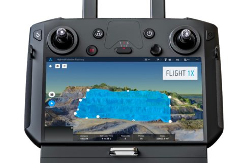
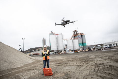
Skycatch maps out autonomous mining future with DJI M300 mapping, analytics solution

San Francisco-based Skycatch has been making waves in the drone space with a range of mapping solutions tailored for mining applications but, according to Chief Technology Officer, David Chen, it thinks of itself as a “software-first company”.

He explained to IM: “We are really a computer vision company, and we focus on building not only the drone solution, but the software that enables it.”

This sees the company provide data capture automation, processing, visualisation and analysis tools to the industry for efficient decision making.

Chen added: “We work with a number of the top mining companies across the globe, providing them with unique solutions that they are using every day to complement their existing survey processes.”

The company, which has become a leader in highwall mapping through these solutions, is expanding beyond surveys into other areas.

This will be facilitated through software like its Flight1X, a cloud-based solution designed specifically for the recently launched DJI M300 drone that, Skycatch says, delivers unprecedented drone mapping accuracy and inspection automation for operations like mines. The proprietary software offers the most complete end-to-end high precision industrial drone capabilities available today, according to the company.

Flight1X, launched at MINExpo 2021 today, comes with proven data and network security via Skycatch servers in the USA, with the Android-based flight planning application running on the M300 Smart Controller. When combined with Datahub, Skycatch’s cloud-based solution, the pair offer mission planning and data visualisation.

Chen expanded on some of these capabilities.

“The majority of drone software out there has been focused on 2D mapping, whereas we have seen that mining, which comes with dynamic and undulating terrain, requires something different.

“What we are building is an automated mission planner where the primary view is of 3D terrain. This planner allows you to bring in existing terrain data from elsewhere or capture and process data from our own platform. The user can then rotate around this map and see the exact mission profile in 3D for improved visualisation and decision making.”

This data integration piece, which hinges on the cloud-based Flight1X platform, could provide Skycatch with an ‘in’ to the tailings dam monitoring market.

“While we’re already providing some survey solutions for tailings dams, the combination of high precision survey (with cm-level precision) for dam movements, fully automated section missions based on RGB and thermal imaging, and machine learning could provide data on dam seepage, for instance,” Chen said.

“We also want to integrate IoT sensors around dam movement and other areas into this cloud-based platform to provide an overall view of the tailings management facility.”

Skycatch is currently working on integrating the DJI M300 and L1 & P1 sensors – purpose built for mapping and surveying – into its offering, with Chen seeing the process as just the next stage in facilitating the autonomous mine of the future.

“The one thing that fully autonomous mines need is a map of the mine for these autonomous machines to operate off,” he said. “We have a focus on making data more accurate, accessible and faster; making it faster is the key for fully autonomous mining.

“Right now, with the current photogrammetry process, it’s still: capture, process and wait a few hours for a map. To be fully autonomous, you need that dynamic map in near real time, which is what we can offer the industry.”

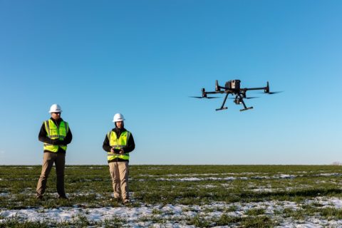
Propeller Aero to integrate with new DJI drone, sensor for rapid and precise site mapping

Propeller Aero, the drone data visualisation and analytics platform, and DJI, a leader in civilian drones and aerial imaging technology, have expanded their partnership to include compatibility of Propeller’s site surveying and 3D mapping software with DJI’s Matrice 300 RTK drone (M300) and Zenmuse P1 sensor (P1).

Propeller’s data processing platform is, the company says, uniquely designed for site surveying and 3D mapping for the construction, earthworks and mining industries. When combined with DJI’s advanced M300 drone, which features a refined propulsion system and longer flight time, the solution can rapidly and precisely map hundreds of acres accurately within 30 mm, making it ideal for surveying medium-to-large scale work sites such as highways, industrial complexes and mines.

The Zenmuse P1 is DJI’s newest flagship sensor, designed specifically for photogrammetry missions. Integrating a full-frame sensor on a three-axis, stabilised gimbal, it substantially increases efficiency and accuracy for surveying and mapping applications, according to Propeller.

“Drone survey data and 3D site maps provide teams across the worksite a single source of truth to better plan, track, inspect and work more safely and efficiently,” the company says. “Additionally, by facilitating quicker data collection, expanding coverage, and offering more real-time progress data, site managers can reduce labour costs and optimise available machinery.”

Jack Nachazel, Customer Success Engineer at Propeller Aero, said: “Work sites have never been as safe, efficient and data-empowered as they are today, thanks to the advances in technology use on-site.

“Our customers are building everything from airports to highways, using a drone that can best capture the unique characteristics of their site. Through our expanded partnership with DJI, they will now be able to streamline their data collection and processing with the powerful M300 drone, which many of our customers are already using.”

To use the solution, surveyors place Propeller AeroPoints™ (smart ground control points) around the worksite, fly the M300 drone above to collect survey data and upload that data to Propeller’s cloud-based platform where it is processed within 24 hours.

The full solution will be available through Propeller’s channel partnership with Trimble®, a leader in positioning technologies, and through its SITECH® distribution network as Trimble Stratus, powered by Propeller, a 3D cloud-based visualisation platform developed by Propeller which integrates with Trimble Connected Site® solutions.

Nevada Gold Mines (owned 61.5% by Barrick, 38.5% by Newmont) is one mining company to have used Trimble Stratus, powered by Propeller, to help measure stockpiles at its mine sites across Nevada.

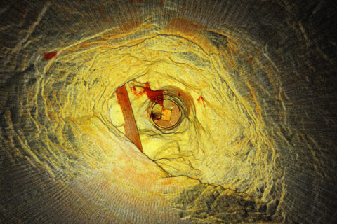
Emesent’s Hovermap aids ore pass decision making at Petra’s Finsch diamond mine

Highly accurate point cloud data sets from a Hovermap scan have allowed Petra Diamonds’ Finsch mine engineers to “see” the condition of ore passes for the first time and avoid an estimated five months and R5 million ($350,000) in remediation, Emesent says.

Finsch, in South Africa’s Northern Cape, uses ore passes and underground silos to transfer ore between levels or to redirect ore for load and haul to the surface. Blockages, hang-ups, overbreak or scaling can impact the structural integrity and result in extended downtime and significant remediation costs. Accurate imagery enables mine engineers to gauge the integrity of ore passes and plan timely and cost-effective remediation programs, according to Emesent.

Historically, however, scanning and mapping inaccessible shafts and voids has been a challenge for Petra.

The company’s management sought a means of obtaining accurate visualisations of underground voids, quickly and cost effectively, without endangering the safety of Petra personnel or contractors, Emesent says.

Petra management trialled the Hovermap multiple data capture methods with Emesent partner, Dwyka Mining Services, contracted to carry out multiple scans of an indoor stockpile, ore passes and vertical shafts, and a series of access tunnels and ramps.

Hovermap is a drone autonomy and LiDAR mapping payload. It uses the LiDAR data and advanced algorithms on-board, in real time, to provide reliable and accurate localisation and navigation without the need for GPS.

Dwyka spent a day on-site conducting a series of scans using Hovermap mounted to vehicles, a DJI drone, or lowered in a protective cage. Dwyka delivered point cloud data sets for Petra’s survey team to geo-reference and analyse, within 24 hours. It also provided visualisations of the ore passes, enabling the mine engineers to ‘see’ the condition of orepasses for the first time, Emesent said.

Alex Holder, Group Planning and Projects Lead at Petra Diamonds, explained: “We lowered Hovermap down ore passes, flew the drone into draw points and even scanned our shaft and ramps by fixing the scanner to one of our vehicles. The visualisation delivered exceeded all our expectations. The data captured in one ore pass saved us significant time and effort by confirming it was irreparable. That saved us millions.”

Using Hovermap led to an immediate decision to abandon plans to expend resources remediating a compromised ore shaft. This decision saved Petra an estimated five months and R5 million.

Heinrich Westermann, Mining Engineer at Petra Diamonds, said: “The ability to power and switch the Hovermap payload between the various applications meant that we were able to scan a considerable amount of the mine in one shift. Generally, this was either impossible and, if it were possible, it would take weeks to collect those datasets and months to see the final visuals.”

The data collected by Hovermap has become the basis of a data library for the site. It is augmented regularly and used to inform operational decision making by Petra’s mine planning and survey teams, according to Emesent.

Petra intends to deploy Hovermap scanning technology to map inaccessible locations at its other sites across Africa, Emesent says.

Emesent achieves ‘industry first’ flight with DJI drone

Emesent has allowed DJI’s M300 drone to fly autonomously underground in what it believes to be a world first for the platform.

The flights took place on August 4 at the Round Oak Minerals-owned Mt Colin copper mine in Cloncurry, Queensland, and were followed by similarly successful flights at another underground mine in north Queensland on August 13, Emesent said.

Emesent’s Hovermap LiDAR mapping and autonomy payload was used to add advanced autonomy to the newly launched DJI Matrice 300 RTK (M300). Coupling Hovermap with the M300 allows users to let the drone fly autonomously and safely into GPS-denied or inaccessible environments, such as densely packed warehouses, the undersides of bridges and in underground mines, Emesent says.

Mt Colin Mine Surveyor, Ashley Tibbles, said the Emesent technology would enable Round Oak to safely access complex locations quickly, and to a high degree of detail.

“Quality data has always been integral to safety and productivity in the underground mining sector,” Tibbles said. “The Hovermap provides an unparalleled platform to deliver this.”

Hovermap uses the LiDAR data and advanced algorithms on-board, in real time, to provide reliable and accurate localisation and navigation without the need for GPS, Emesent says.

Emesent CEO, Dr Stefan Hrabar, said the success of the underground flights with the Hovermap-enabled M300 will open up new possibilities for underground mines.

“The M300 is an excellent match for carrying Hovermap underground because of its flight endurance, IP rating, and ability to carry additional sensors such as cameras,” he said. “This will allow valuable data capture further into inaccessible areas of the mines.”

Dr Hrabar added: “Robust underground flight technology can significantly extend the capability of industrial drones and will deliver real benefits to the mining, construction and emergency response sectors.

“We’re looking forward to partnering with customers to help them derive competitive advantage from this breakthrough technology.”

SUEK-Kuzbass takes to the skies for surveying and land management surveys

SUEK says it has purchased six unmanned aerial vehicles (UAVs) with various modifications intended for aerial photography during surveying operations of its Kuzbass facilities, in the Kemerovo region of Russia.

The decision to develop the company’s fleet of UAVs was made after a test of aerial photography at SUEK’s open-pit mines in the Krasnoyarsk region and Buryatia, the company said. “After analysing the accuracy and detail of 3D terrain models obtained using UAVs, SUEK concluded that this technology could be used for surveying and land management in mining,” it said.

In August 2018, the Aerial Surveying Office was established as part of the technical directorate in Kuzbass. Today, the office is equipped with two Russia-made UAVs capable of making aerial photographs at a height up to 1 km, with a flight duration of two-and-a-half and four hours, respectively.

SUEK’s fleet also includes four compact DJI drones and a GNSS receiver that makes it possible to receive and process signals from all navigation satellite systems that exist today, it says. This latter device enables surveyors to locate UAVs during aerial photography.

Simultaneously with the procurement of equipment and staff training, the Aerial Surveying Office has made efforts to satisfy the requirements of the mandatory registration of UAVs with the Federal Air Transport Agency, to ensure compliance with legislation governing the use of Russian airspace, the process of aerial photography and the operation of UAVs, SUEK said.

The technology is helping the company solve a whole range of issues related to open-pit mining, such as evaluating the size of coal storage facilities, monitoring hazardous situations, updating topographic plans of work areas and surrounding territories, and monitoring the use of company land. The latter includes actual use of allotted land, the intended purpose of the land, reclamation, demolition control in buffer zones and property stock taking, the company said.

Anatoly Meshkov, Technical Director of SUEK-Kuzbass, said: “First of all, UAVs improve the efficiency and safety of surveying measurements and the accuracy of necessary calculations. We can now remotely control mining operations at almost any point and build digital enterprise models.

“Essentially, this is another step towards creating a ‘digital underground mine’ and a ‘digital open-pit mine’ to obtain the maximum amount of data for highly efficient management of coal production processes.”

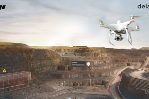
DJI and Delair team up to improve operational efficiencies using drones

DJI, a civilian drones and aerial imaging technology company, and Delair, a provider of visual data management solutions for enterprise, have announced a partnership that will see the two companies collaborate on enhanced and integrated solutions for visual data collection and analysis for businesses.

The partnership will include an agreement for Delair to sell DJI products through its worldwide sales channel, along with launching a relationship to build compatibility across platforms, they said. One of the industries likely to benefit from the collaboration is mining.

Jan Gasparic, Director of Strategic Partnerships at DJI, said: “DJI is incredibly excited to be working more closely with the Delair team to support their vision of building a leading software suite.

“At DJI, we aim at providing reliable, scalable drone offerings that empower organisations such as Delair to build software solutions that allow businesses across a range of sectors to benefit from drone data. The partnership is an important agreement that demonstrates an increasing maturity in the enterprise drone industry. It reinforces the benefit of collaboration within the drone ecosystem to deliver more value to customers.”

The partnership builds on the two companies’ success in the enterprise market, and firmly establishes Delair as a leading provider of complete, end-to-end visual intelligence solutions, the two said. DJI drones are, according to the company’s own estimates, the most deployed drone hardware for enterprises today. “This partnership facilitates the accessibility to incorporate both DJI drone products and Delair’s data management platform, providing a hassle-free option for enterprise drone programs,” they said.

Benjamin Benharrosh, Co-Founder and VP Sales at Delair, said drones for enterprise are more than just hardware solutions: the real key is tapping into and leveraging the data these powerful machines can gather.

“DJI’s developer technologies and existing installed base allow Delair to build an industry-leading analytics suite that can be utilised instantly across a customer’s fleet,” he said. “Both DJI and Delair recognise the importance of providing enterprise-calibre solutions from trusted partners to enable true digital transformations by our customers. We are confident this partnership will further accelerate how businesses can improve their operational efficiencies using drones.”

The relationship strengthens Delair’s ability to serve key industry sectors increasingly relying on visual data to drive their businesses, such as construction, transportation and infrastructure, utilities, mining and agriculture, the companies said.

Through the support of DJI systems with the delair.ai platform, customers will now have a one-stop shop and  freedom of choice in using the cloud-based system’s wide range of tools to help derive insights from drone data, including industry-specific analytics tools optimised for specific use cases, the companies said.

Delair’s platform allows companies to manage, process, view, analyse and collaborate around aerial data. In a mining context, this could see firms control and report on inventory, support a safety road map or, optimise and maintain haul roads.

“Some of the off-the-shelf features and analytics for extracting business intelligence include creating digital twins, field inventory calculations, vegetation encroachment, automatic defect detection, automatic stockpile detection and volume measurements, along with any application which is based on AI object detection for asset management,” the companies concluded.

Drone specialists Kespry and DJI combine forces to improve stockpile monitoring

Kespry and DJI are pooling resources to offer the DJI Mavic 2 Pro drone as part of the Kespry stockpile measurement solution for mining and aggregates companies.

“This solution delivers the unique Kespry autonomous flight and aerial intelligence experience for stockpile measurement using a DJI drone,” according to Kespry.

“Adding this affordable, powerful and portable solution will enable large aggregates and mining companies to standardise and capture stockpile data across all their sites in the Kespry platform, while continuing to use the high-accuracy Kespry 2 drones to support mine and site planning operations.”

Integration of data captured from a DJI drone is the next innovation in the development of the Kespry industrial sensor platform, according to the company.

To date, Kespry has built a customer base of more than 200 mining and aggregates companies by providing drones for more accurate, easier to use, and safer ways to provide inventory management and mine planning data.

“As these customers scale their use of drone data, they are looking to standardise on a single platform to organise and analyse that data across sites, geographies, and product divisions – even when those sites are highly distributed,” Kespry says.

The addition of the DJI Mavic 2 Pro to the Kespry lineup is designed to enable even more site data to be centralised in the Kespry cloud.

George Mathew, CEO and Chairman of Kespry, said: “Drone data is now the standard approach for measuring stockpiles at mine sites, however, millions of dollars are wasted through reconciling inconsistent data from different platforms and the time involved getting that data ready for analysis.”

“Our goal with the addition of the Mavic 2 Pro to our solution is to respond to our customers wishing to use the Kespry aerial intelligence platform across all mine sites to standardise how stockpile data is generated – lowering their costs and helping drive the profitability of every site.”

Jan Gasparic, Director of Strategic Partnerships at DJI, said: “Pairing the Mavic 2 Pro with Kespry’s industry-leading AI, ML, and analytics capabilities will be of enormous benefit to mining companies that are looking to take advantage of drone technology in a portable and powerful package.”

The integration of DJI’s drone and sensors into the Kespry platform is the latest innovation in the delivery of an industrial sensor network, closely following Kespry’s recently-announced high-resolution thermal capabilities for industrial inspection.

The Kespry platform is now capable of processing and analysing a wide range of sensor data, enabling the future creation of industry-specific applications, including those under current development with leaders in the energy sector.

Kespry is offering the Mavic 2 Pro as part of its fully-managed, end-to-end annual subscription model. Kespry customers that choose the Mavic 2 Pro for stockpile measurement will benefit from the full Kespry experience, including its support, training, customer success team, and drone up-time guarantee.

The Kespry stockpile measurement solution with DJI will be available in the first quarter of next year.