Tag Archives: mapping

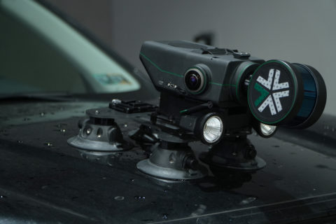
Exyn launches Nexys, a modular 3D mapping solution for mining sector

Exyn Technologies has announced Exyn Nexys, a cutting-edge modular 3D mapping solution specifically designed to meet the unique needs of the mining industry, among others, at the SME MineXchange Conference and Expo, in Phoenix, Arizona.

Nexys stands out as a benchmark in autonomous mapping technology, delivering unmatched flexibility, speed and accuracy for surveying and inspection tasks in the most challenging and intricate environments, Exyn claims.

“Nexys boasts an innovative modular design that supports deployment in various configurations, including handheld, backpack-mounted, vehicle-mounted, drone-integrated, or via ground robots,” the company says. “This versatility renders Nexys an indispensable tool for comprehensive mapping in diverse environments, particularly underground and indoor spaces unique to mining, as well as rugged outdoor terrains.”

Equipped with advanced LiDAR technology and Exyn’s proprietary SLAM algorithms, Nexys achieves fast and efficient data capture speeds and real-time point cloud colourisation, the company says. When mounted on a robot, its Autonomy Level 4 (AL-4) capabilities enable intelligent autonomous navigation through dynamic, complex environments, guaranteeing extensive coverage even in GPS-denied areas critical for mining.

With integrated hemispherical cameras, Nexys provides immediate visualisation of detailed, colourised data directly onto a 3D point cloud. Capable of capturing up to 1.9 million scan points per second, it guarantees survey-grade accuracy up to 5 mm at 1 sigma, essential for precision-driven surveying and mapping operations in the mining sector, Exyn says.

Designed to IP67 standards within an ISO 9001 certified framework, Nexys is engineered to endure the harshest mining conditions. Its ergonomic design is complemented by a comprehensive suite of accessories, including GPS modules, protective cages and Drone Link for seamless robot integration, enhancing its utility in numerous mining scenarios.

Brandon Torres Declet, CEO of Exyn Technologies, said: “We are thrilled to introduce Exyn Nexys to the mining world, a reflection of Exyn’s unwavering commitment to innovation and our ambition to transform the landscape of mapping and surveying.”

Raffi Jabrayan, VP, Business Development of Exyn, added: “Nexys is specifically engineered to navigate the complex and hazardous environments of underground mines, offering unmatched accuracy, efficiency and safety in orebody mapping, stope condition monitoring and operational planning. This is a significant leap forward in our mission to enhance mine productivity and worker safety through cutting-edge autonomous mapping solutions.”

ProStar’s PointMan utility mapping solution to be adopted at IAMGOLD operations

ProStar Holdings Inc says IAMGOLD Corporation has adopted its flagship software application, PointMan, to improve its safety operations.

IAMGOLD employs approximately 5,000 people globally and is committed to maintaining its culture of accountable mining through high standards of environmental, social and governance practices, including its commitment to Zero Harm®, in every aspect of its business, ProStar says.

PointMan is a patented cloud and mobile mapping software application that captures, records and displays the precise location and associated metadata of critical surface and subsurface infrastructure, according to ProStar.

Philippe Gaultier, Vice President of Development Projects at IAMGOLD, said the company planned to use the mapping solution to identify any utility infrastructure that is buried in the ground, “which can be a serious concern in terms of worker and environmental safety as well as operational costs.”

Page Tucker, CEO of ProStar, added: “Having a global mining company like IAMGOLD adopt PointMan into their mining operations is a major milestone for us. Not only does it open the door to another global industry, but it also proves that PointMan addresses the growing concern of not knowing where buried utilities are located, a problem that adversely impacts the safety of the public, the worker and the environment in a multitude of industries.”

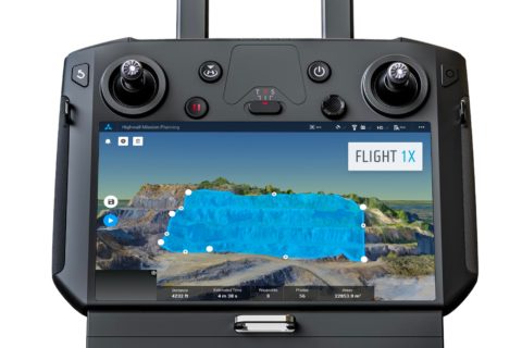
Skycatch maps out autonomous mining future with DJI M300 mapping, analytics solution

San Francisco-based Skycatch has been making waves in the drone space with a range of mapping solutions tailored for mining applications but, according to Chief Technology Officer, David Chen, it thinks of itself as a “software-first company”.

He explained to IM: “We are really a computer vision company, and we focus on building not only the drone solution, but the software that enables it.”

This sees the company provide data capture automation, processing, visualisation and analysis tools to the industry for efficient decision making.

Chen added: “We work with a number of the top mining companies across the globe, providing them with unique solutions that they are using every day to complement their existing survey processes.”

The company, which has become a leader in highwall mapping through these solutions, is expanding beyond surveys into other areas.

This will be facilitated through software like its Flight1X, a cloud-based solution designed specifically for the recently launched DJI M300 drone that, Skycatch says, delivers unprecedented drone mapping accuracy and inspection automation for operations like mines. The proprietary software offers the most complete end-to-end high precision industrial drone capabilities available today, according to the company.

Flight1X, launched at MINExpo 2021 today, comes with proven data and network security via Skycatch servers in the USA, with the Android-based flight planning application running on the M300 Smart Controller. When combined with Datahub, Skycatch’s cloud-based solution, the pair offer mission planning and data visualisation.

Chen expanded on some of these capabilities.

“The majority of drone software out there has been focused on 2D mapping, whereas we have seen that mining, which comes with dynamic and undulating terrain, requires something different.

“What we are building is an automated mission planner where the primary view is of 3D terrain. This planner allows you to bring in existing terrain data from elsewhere or capture and process data from our own platform. The user can then rotate around this map and see the exact mission profile in 3D for improved visualisation and decision making.”

This data integration piece, which hinges on the cloud-based Flight1X platform, could provide Skycatch with an ‘in’ to the tailings dam monitoring market.

“While we’re already providing some survey solutions for tailings dams, the combination of high precision survey (with cm-level precision) for dam movements, fully automated section missions based on RGB and thermal imaging, and machine learning could provide data on dam seepage, for instance,” Chen said.

“We also want to integrate IoT sensors around dam movement and other areas into this cloud-based platform to provide an overall view of the tailings management facility.”

Skycatch is currently working on integrating the DJI M300 and L1 & P1 sensors – purpose built for mapping and surveying – into its offering, with Chen seeing the process as just the next stage in facilitating the autonomous mine of the future.

“The one thing that fully autonomous mines need is a map of the mine for these autonomous machines to operate off,” he said. “We have a focus on making data more accurate, accessible and faster; making it faster is the key for fully autonomous mining.

“Right now, with the current photogrammetry process, it’s still: capture, process and wait a few hours for a map. To be fully autonomous, you need that dynamic map in near real time, which is what we can offer the industry.”

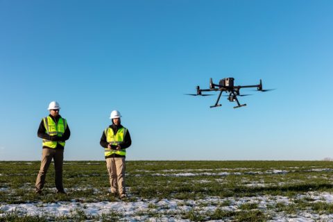
Propeller Aero to integrate with new DJI drone, sensor for rapid and precise site mapping

Propeller Aero, the drone data visualisation and analytics platform, and DJI, a leader in civilian drones and aerial imaging technology, have expanded their partnership to include compatibility of Propeller’s site surveying and 3D mapping software with DJI’s Matrice 300 RTK drone (M300) and Zenmuse P1 sensor (P1).

Propeller’s data processing platform is, the company says, uniquely designed for site surveying and 3D mapping for the construction, earthworks and mining industries. When combined with DJI’s advanced M300 drone, which features a refined propulsion system and longer flight time, the solution can rapidly and precisely map hundreds of acres accurately within 30 mm, making it ideal for surveying medium-to-large scale work sites such as highways, industrial complexes and mines.

The Zenmuse P1 is DJI’s newest flagship sensor, designed specifically for photogrammetry missions. Integrating a full-frame sensor on a three-axis, stabilised gimbal, it substantially increases efficiency and accuracy for surveying and mapping applications, according to Propeller.

“Drone survey data and 3D site maps provide teams across the worksite a single source of truth to better plan, track, inspect and work more safely and efficiently,” the company says. “Additionally, by facilitating quicker data collection, expanding coverage, and offering more real-time progress data, site managers can reduce labour costs and optimise available machinery.”

Jack Nachazel, Customer Success Engineer at Propeller Aero, said: “Work sites have never been as safe, efficient and data-empowered as they are today, thanks to the advances in technology use on-site.

“Our customers are building everything from airports to highways, using a drone that can best capture the unique characteristics of their site. Through our expanded partnership with DJI, they will now be able to streamline their data collection and processing with the powerful M300 drone, which many of our customers are already using.”

To use the solution, surveyors place Propeller AeroPoints™ (smart ground control points) around the worksite, fly the M300 drone above to collect survey data and upload that data to Propeller’s cloud-based platform where it is processed within 24 hours.

The full solution will be available through Propeller’s channel partnership with Trimble®, a leader in positioning technologies, and through its SITECH® distribution network as Trimble Stratus, powered by Propeller, a 3D cloud-based visualisation platform developed by Propeller which integrates with Trimble Connected Site® solutions.

Nevada Gold Mines (owned 61.5% by Barrick, 38.5% by Newmont) is one mining company to have used Trimble Stratus, powered by Propeller, to help measure stockpiles at its mine sites across Nevada.

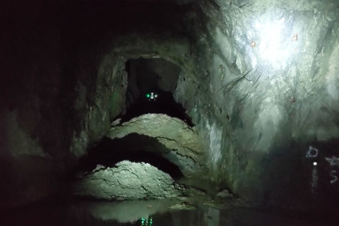
Exyn drones help Rupert Resources map Pahtavaara gold mine

Exyn Technologies says it has completed a successful mission for Rupert Resources at its historic Pahtavaara gold mine in northern Finland.

By harnessing Exyn’s autonomous drones, Rupert Resources was able to produce highly detailed 3D models of the mine, which is otherwise completely inaccessible to traditional CMS tools or even manually piloted drones, Exyn said.

“Rupert Resources needed to plan for a potential restart of operations by estimating tonnage previously removed from the mine, as well as calculating the remaining ore in heavily restricted areas,” the company said.

Exyn’s fully autonomous aerial robots mapped 30 stopes in three days with a single drone. In addition, Exyn mounted a version of its robot to a car to scan all access drifts which, together with the stope maps, provided a complete mine map in under four days.

Jukka Nieminen, Managing Director of Rupert Finland, said: “Rupert is actively seeking new technologies where we think big gains can be made in terms of safety, productivity and accuracy.

“Exyn achieved accurate assessment of the volume of remaining stopes at Pahtavaara with an unprecedented level of detail, and obviously the use of remote technologies means that this was achieved with a greatly reduced degree of risk. We have no hesitation in recommending this technology.”

Exyn’s autonomous drones are built on the exynAI™ platform, enabling aerial robots to fly intelligently without a human pilot using a multitude of high-tech sensors and AI-based software, the company says. The system operates without the need for GPS or external communications, and is deployed as an all-in-one software and hardware package.

Raffi Jabrayan, Director of Markets & Industries, Exyn Technologies, said: “Our mission with Rupert presented some of the most difficult and seemingly impossible challenges to navigating, analysing, and assessing a mine – which therefore makes it exemplary in demonstrating the heights of Exyn’s capabilities.

“Our AI-based software and state-of-the-art sensors were able to get the job done quickly and safely, proving once again that no exploration task is impossible for Exyn drones.”

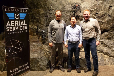
Terra Drone captures North America market share with UAS Inc deal

Japan’s Terra Drone is to form a new subsidiary in Canada, Terra Drone Mining, following the signing of an investment agreement with Ontario-based Unmanned Aerial Services Incorporated (UAS Inc).

Established in 2017, UAS inc is an inspection service provider for indoor industrial confined spaces and underground mine locations. It counts among its clients some of the world’s leading mining companies including Vale, Newmont Goldcorp, Barrick Gold, and Glencore.

The agreement will see Terra Drone Mining provide cutting-edge unmanned mapping and inspection services to underground mines across the world, according to Terra Drone, with the investment allowing the newly-formed company to expand UAS Inc’s business beyond North America into South/Central America, South Africa, Central Asia, Russia, and Australia.

Terra Drone said: “Accidents in underground mines have remained a serious issue around the world throughout the last century. Workers not only suffer from health issues caused by working in dark and narrow tunnels day after day, but they are also prone to accidents caused by falling material, flooding, as well as underground fires and explosions.

“The risk of such incidents can be minimised by using unmanned inspection solutions, aka drones.”

Terra Drone uses a mapping technology called Simultaneous Localisation and Mapping (SLAM) to create highly detailed maps of underground areas. Since a drone can reach areas that are not easily or safely accessible to humans or traditional CMS scanners, mine operators can use drones to obtain 3D models of the mines, and prevent workers from entering hazardous locations.

Terra Drone concluded: “Terra Drone Mining will be able to leverage both this advanced UAV technology as well as the underground mining inspection know-how that UAS Inc has cultivated over time to create a robust local service network.”

Mine Vision Systems and Peck Tech to combine 3D mobile mapping expertise

Mine Vision Systems and Peck Tech Consulting have announced the intent to combine their products, services and expertise to deliver, they say, “industry leading, innovative 3D mobile mapping solutions for GPS-denied environments.”

MVS is an industry funded spin-off from Carnegie Mellon University’s National Robotics Engineering Center with a portfolio of patented and proprietary solutions for automated geotechnical and geologic analysis and standardised reporting of information critical to underground mining operations, it says.

Peck Tech, meanwhile, is a global provider of advanced sensing, monitoring, control and automation consulting services and products to the mining industry. It was also recently engaged by RNC Minerals for an autonomous haulage solution study on the Dumont nickel-copper project, in Quebec, Canada.

For the past five years, the two companies have independently pursued the development and sales of advanced sensor-based, mobile 3D localisation and mapping solutions to underground mining and utility customers on a global basis.

This has allowed both to “establish…a solid, growing customer base for their products and fostered an internal commitment to continuously seek new and innovative mobile scanning solutions that can address a wide range of safety and productivity issues present in their customer’s mining operations,” they said.

Dr Scott Thayer, Chief Executive Officer, MVS, said the company is committed to building and delivering the best mobile mapping solutions it can for its customers to allow them to derive significant value from their routine operational use.

“By partnering with Peck Tech, we will be able to combine the solutions and capabilities of proven industry pioneers in the mobile scanning and mapping space to further enhance the value that we can deliver to our customers by offering a much broader range of product and services option,” he said.

Dr Jonathan Peck, Chief Executive Officer and President, Peck Tech, said MVS and Peck Tech are already aligned in many areas including sharing a common vision for the future market opportunities for LiDAR and optical-based 3D mobile mapping solutions.

“By combining our product strengths and complementary skills, experience and knowledge, the broad suite of advanced solutions that will result will deliver significant productivity and safety benefits and choices to both our underground and open-pit mining customers,” he said.

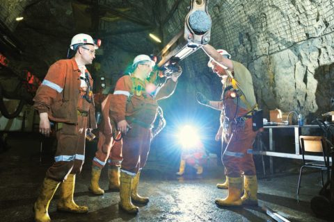
Dundee Precious Metals to map underground mines with Exyn A3R autonomous drones

Exyn Technologies says it has signed up Dundee Precious Metals as the first commercial customer for its Autonomy Aerial Robots (A3Rs).

Dundee will use the fully autonomous aerial system for data collection in GPS-denied environments to advance its initiatives focused on the digitisation and automation of its underground mining operations, according to Exyn.

Theophile Yameogo, Vice President Digital Innovation, Dundee Precious Metals, said, “The Exyn A3Rs allow frequent and hi-resolution mapping of underground environments while reducing risks to personnel.”

Yameogo said the company was already very excited at the results of the maps it was seeing. “As we further integrate the A3Rs into our workflow, we anticipate a transformation of operations compared to today’s models,” he added.

Exyn’s A3Rs are driven by the company’s proprietary software, exynAI™, a robust commercially available software platform enabling full autonomy for aerial robots. Exyn has deployed its A3Rs as a service for customers in the US, Latin America and Europe.

By using Exyn’s aerial robots to automate mapping and surveying, Dundee is, Exyn says, transforming its underground operations in three vital areas:

  • Improving the quality of mapping data captured when compared with traditional surveying techniques;
  • Improving safety by reducing the amount of time spent underground by human operators, and;
  • Increasing operational efficiency by having more accurate and up-to-date information for mine planning.

Exyn’s A3Rs operate without the need for a human pilot and in GPS-denied environments. The company said: “They are fully self-contained, intelligent systems designed to operate without the need for any prior information, persistent communication, or GPS. With all intelligence on board, the vehicle is capable of carrying out high-level missions in complex and completely unknown spaces.”

Exyn’s multi-sensor data fusion pipeline allows each robot to assimilate measurements from a variety of on-board sensors including 3D LIDAR, cameras, and inertial sensors to “generate a robust state estimate of itself and surrounding environments”.

When married with Exyn’s real-time navigation software stack, the robots can safely avoid collisions with both stationary and moving obstacles during requested missions, according to the company. “Moreover, its robots are also able to do real-time Simultaneous Localisation and Mapping to enable highly accurate map generation.”

Dundee operates the Chelopech underground copper-gold mine in Bulgaria and is soon to be producing gold at the Krumovgrad project, also in Bulgaria.