Tag Archives: mine design

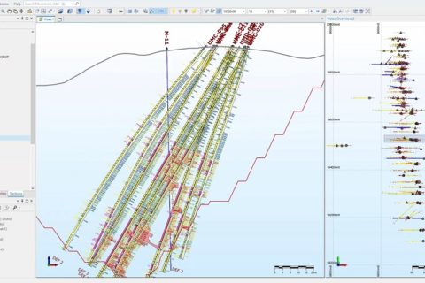
Guanajuato Silver reduces costs, optimises workflow with Micromine software solution

Micromine says Guanajuato Silver Company has chosen Micromine as its primary geological and mine design software provider.

Micromine Origin and Micromine Beyond software will soon be implemented across four active mine sites – El Cubo, Valenciana, San Ignacio and Topia.

Guanajuato Silver chose Micromine Origin and Micromine Beyond due to the comprehensive functionality, which has enabled the company to replace multiple geological modelling, mapping and mine design applications with Micromine’s powerful all-in-one solution, Micromine said.

James Anderson, Chairman & CEO of Guanajuato Silver, said: “We believe both Micromine Origin and Micromine Beyond will enhance the performance of our mine exploration and engineering teams. By consolidating multiple software licences into one comprehensive package, we have been able to reduce our software costs while optimising workflows. We are also confident that Micromine’s strong support and commitment to customer success will help us achieve our goals as we continue on our journey to reactivate silver and gold mines in Guanajuato.”

Guido Perez, Micromine’s Regional Manager for the Americas region, said: “I regularly hear from geologists who are frustrated about the amount of time they are losing transferring data between multiple applications. It’s been a great experience for us to work with Guanajuato Silver to solve this problem for their team. By implementing a single software solution that covers multiple steps in the mining process, their team can stop worrying about managing software and start focusing on what matters.”

As one of the fastest-growing silver producers in Mexico, Guanajuato Silver also placed high importance on access to multi-language training and support for its rapidly growing team, the software provider said. Micromine has responded to this need quickly, already hosting in-person training sessions with over 50 users on-site in Guanajuato, Mexico.

The implementation of Micromine Origin and Micromine Beyond is just the first step in the ongoing relationship between Guanajuato Silver and Micromine, according to the latter. The organisations are currently collaborating on a program to support mining students in the Guanajuato region in developing the technical skills required for their future careers.

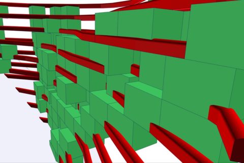
MICROMINE opens 3D mine design and planning solution for sharing

MICROMINE is launching an exclusive new viewer, Micromine Effects (MFX), to make sharing complex design and visualisation files much easier.

Like a PDF reader, the free utility enables anyone to view, share and interrogate Micromine output files without needing access to a full software licence, the company said.

“For the first time, sophisticated data analysis and design models are no longer locked away with technical teams,” the mining software leader said. “Instead, they can be shared, quickly and easily, with consultants, clients and colleagues.”

Built on the power of the Micromine’s Vizex, its 3D visualisation environment – and advanced functionality incorporated in the recently released Micromine 2020.5 – MFX allows users to attach any Micromine project and load any number of displays, the company says.

MICROMINE Chief Strategy Product Officer, Paul Hooykaas, said Micromine MFX was designed for collaboration and communication, so anyone could view models and provide feedback.

“It can be costly and time-consuming to explain plans to clients and other people in the business who may not have the same level of technical understanding,” Hooykaas said.

“MFX allows you to show them. Sharing models is as easy as simply sharing your project with someone who can download MFX software for free, in seconds.”

MFX has a level of interactivity that goes beyond what is expected from most file viewers, MICROMINE claims.

“Users can view preconfigured models with any number of display layers,” it says. “They can control the appearance of layers and toggle them on or off – even see multiple views in different windows, apply filters to data displayed in a layer and generate high resolution screenshots.”

The user interface offers drag and drop functionality and interactive tools like zoom-to-selection and a measurement device.

“The advanced display options include transparency and interactive block model visibility, with flexible view management including Section Control Files,” MICROMINE explained. “Clipping planes can be defined, with the clipped section limits highlighted as ‘corridors’ in related views. Shadow sections include seeing next and previous sections together with the current section.”

Micromine 2020 to provide ‘superior functionality’ across mining value chain

Micromine 2020 has officially hit the markets today, with its developer saying it will cover everything mine designers need from intuitive charting and 3D visualisations to rapid geological modelling and precision planning.

The release builds on MICROMINE’s already popular 3D mine design and planning solution, which is used in over 90 countries.

Micromine Technical Product Manager, Gordon Thomas, said: “Micromine 2020 offers intuitive, feature-rich solutions that meet our clients’ needs and delivers superior functionality across the entire mining value chain.

“Geologists, engineers, mine planners and production schedulers can all benefit from the enhanced speed, efficiency, tools and features of MICROMINE’s new software.”

One of the most compelling added features in Micromine 2020 is the new stope optimisation tool, which MICROMINE previously delved into.

“The underground equivalent of Micromine’s existing pit optimiser module, stope optimiser gives mine planners the means to generate optimal stope outlines to meet design and economic parameters,” Thomas said.

“For open-pit miners, the stope optimiser can also generate the optimum diglines to suit minimum mining widths.”

The addition of new implicit modelling tools for geological modelling is another key upgrade promising to make Micromine 2020 users’ workflows even more efficient and reliable, according to the software developer.

“Micromine 2020’s implicit modelling module can speed up the domain modelling process by 100 times, when compared to manual sectional modelling, while ensuring an accurate result,” Thomas added.

“Conveniently integrated into geologists’ workflow, Micromine 2020 ensures all mining exploration and modelling activities can be done in one place, rather than switching between products and systems.”

Upgrades and new functionalities incorporated into Micromine’s existing scheduler tool also means planning engineers can access these scheduling tools.

“Micromine 2020’s scheduling tool accepts sets of tasks with properties presented in wireframes with attributes and criteria specific to each task – and provides facilities for sequencing the tasks to suit requirements,” Thomas said.

“The tasks are then displayed in a Gantt chart, with the option of creating 3D animations and reports. The updated scheduling tool integrates seamlessly with other Micromine functions and supports both the new expression editor and unit conversion facilities.

“Planners can rest assured they will have the means to satisfy specified objectives, maximise net present value and achieve production targets.”

The company said: “With Micromine’s charts being an integral part of its workflow, the addition of a range of new statistical chart and analysis functionalities in Micromine 2020 gives geologists the means to set up charts according to specific requirements, rather than configuring generic chart options.”

The additional charting tools include Multivariate Histogram Analysis, Ternary Diagram, Top Cut Graph, Boundary Analysis, Swath Plot, Search Neighbourhood, Quantitative Kriging Neighbourhood Analysis, and Grade Tonnage Curve.

Each chart is dedicated to a specific geological or geostatistical scenario, according to Thomas. “Together, in an interactive and visual way, they help geologists make informed decisions where there is no clear-cut answer,” he said.

Another key function of Micromine 2020 is the ring design tool for underground engineers, which enables planning engineers to define the size and configuration of the drill rigs to be used.

“The tool allows users to apply constraints, in accordance with rig specifications. This ensures the range and coverage limits of booms are not inadvertently exceeded during the design process,” Thomas explained. “Rings can be created, viewed, edited, mirrored, copied and replicated using the ring design tool, with feedback provided throughout the design process.”

Other noteworthy new additions in Micromine 2020 include:

  • The ability for explorers and geologists to visualise private and government web map services layers in Vizex;
  • User-friendly import and export options for OMF files, from or to, other GMPs; and
  • An import option for ioGas files.

Enhancements made to the existing Micromine product, meanwhile, include faster block model reporting; faster wireframe assign functionality; enhanced draping and visualising images in Vizex; improved block model regularisation features; data selection functionality using a new lasso tool in Vizex; improved wireframe management tools; improved drill hole creation workflow; and major improvements in the creation and management of Python scripts.

Thomas concluded: “A lot of effort has gone into incorporating improvements and additions that will truly add value to our clients throughout the mining value chain – simplifying and speeding up processes, and helping clients deliver the very best results.”

Seequent adds geotechnical analysis software to growing portfolio

Seequent has announced the acquisition of GEOSLOPE, a Canada-based company famed for its integrated, geotechnical analysis software.

The New Zealand-headquartered leader in the development of geoscience analysis, modelling, and collaborative technologies says the addition of GEOSLOPE will offer additional innovative geoscience technology solutions to its customers.

Seequent has been busy on the business development front in the past year, announcing, in November, that it was to merge with Geosoft and, in July, saying it was starting a partnership with Minalytix.

GEOSLOPE is known by geotechnical engineers who use the GeoStudio suite for design, analysis, and decision making. This suite includes products for modelling slope stability, deformation, heat transfer and groundwater flow in soil and rock. The products are used in over 100 countries for analysing infrastructure projects including dams and levees, reinforced walls and slopes, open-pit mines, and transportation, according to Seequent.

Shaun Maloney, Chief Executive of Seequent, says: “We welcome the GEOSLOPE team to the Seequent family. Together, we are better equipped to deliver on our commitment to help mitigate and solve some of the world’s major civil, environmental and energy challenges.”

GEOSLOPE’S President, Paul Grunau, said the company had, over the years, invested in the long-term growth of the company to develop a set of “world-class solutions” for geotechnical engineers.

He added: “Joining Seequent presents the opportunity for greater integration of geotechnical analysis into the overall engineering and design workflow, thereby enabling our customers to more effectively analyse their problems and deliver better outcomes.”

The GEOSLOPE team will continue to be led by Paul Grunau and will maintain its presence in Calgary, Canada, Seequent said.

Seequent says its software is used on large-scale projects globally, including road and rail tunnel construction, groundwater detection and management, geothermal exploration, subsea infrastructure mapping, resource evaluation and subterranean storage of spent nuclear fuel.

Carlson expands mine software capabilities with Mining 2020

Carlson Mining 2020 has added new options to its recently released Mining 2020 software, including modules for Geology, Surface Mining, and Underground Mining.

Able to run on AutoCAD® 2015-2020 and equipped with IntelliCAD 9.2, it enhances block modelling, variograms, mining solids with improved 3D viewing and rendering, design and scheduling, according to Grant Wenker, Vice President of Carlson Mining.

“These additions further expand the capabilities of the Carlson Mining Suite, linking the office software closer to the Carlson Laser Measurement and Machine Control solutions,” he said.

Carlson Mining 2020’s Variogram features multiple updates including the ability to process multiple strata and attributes at once, data point composting, cross variable geostatistical analysis with cross variograms, a method to auto-fit model variograms, and output lag results, according to the company.

The Block Model Viewer, meanwhile, now shows a legend of grade names and assigned colours. Users can switch the grade parameters for viewing the blocks coloured by a different attribute, without exiting the command, in addition to defining new grade parameters by attribute value range while in the viewer.

The Surface Equipment Timing has several upgrades with the 3D pick tool such as the ability to define attribute equations to display in the charts, tooltip settings that display values, automatic tracking of non-key tonnage, and an undo button, the company said. “Speed has been improved – allowing pit assignment within a few seconds even with up to 35,000 pit blocks,” Carlson Mining said.

There are new commands to create solid models including by grade from a block model and by 3D triangulation from a cloud of points. Additionally, there is a new option to create a solid using a Carlson surface object – providing better performance, as opposed to drawing hatched 3D faces, especially on larger models. The new solid-by-section model uses a series of slices through a model to make edits.

Another new tool within Carlson 2020 is the Settings Migration Wizard. This tool provides a new way to transfer Carlson and CAD settings between previous versions of Carlson. When using Carlson 2020 for the first time, the Migration Wizard gives users the chance to transfer the settings.

Along with Carlson Mining 2020, Carlson is also releasing 2020 versions of Carlson Survey, Carlson Civil, Carlson GIS, and Carlson Hydrology. The release also includes Carlson Takeoff Suite, which is made up of Carlson Construction, Carlson GeoTech, Carlson CADNet, and Carlson Trench modules.

MICROMINE to play leading role in MinEx CRC’s 3D geological modelling project

MICROMINE says it has been selected by MinEx Cooperative Research Centre (CRC) as the sole software provider for the project.

MICROMINE will provide information and advice on software solutions for mineral exploration as part of the A$218 million ($154 million) CRC project, which was set up to develop new technologies to increase the discovery of new mineral deposits.

“Australia’s share of global mineral exploration reduced from about 25% in the 1990s to around 12.5% in recent years,” MICROMINE said. “The decline in activity has driven the establishment of the CRC, which is backed by A$50 million in Australian Government funding and another A$165 million in private sector support.”

MICROMINE joins 34 MinEx CRC partners from the mining equipment, technology and services sector and major miners BHP, South32, Anglo American and Barrick Gold, as well as research organisations in Australia and overseas, such as CSIRO, Geoscience Australia and various universities.

MICROMINE will be involved in the team focused on 3D geological modelling, which brings together mining companies, geological surveys and research institutions from Australia, Canada, France, Germany and the UK.

Mark Gabbitus, Product Strategy Manager for MICROMINE’s exploration and mine design software, Micromine, said: “MICROMINE will work with our project partners to develop a 3D geological and geophysical modelling package, which will help geologists, researchers and exploration companies to find mineral deposits in a more efficient and cost-effective way.”

The resultant solution will allow field geologists, researchers, explorers, resources modellers and managers to better define their 3D geological environment and assess the need for additional data and research, according to the company.

“It will also address existing problems explorers face that are related to urban geology, basin resources exploration and exploitation and mineral and scientific exploration in poly-deformed metamorphosed terranes,” MICROMINE added.

Gabbitus said the CRC complements the work MICROMINE is already undertaking to develop its geological software solution, Geobank.

“MICROMINE will contribute to the development of an open source algorithm, while scoping the development of a commercial version that could fit more seamlessly into the workflow of the explorers or miners that work with Micromine,” he said.

“There is a significant amount of work to do over the coming years but there are some exceptionally smart people involved in the project and it is very exciting for MICROMINE to play a role in developing the next generation of exploration and modelling tools.”