Join us at The Electric Mine 2026
The Electric Mine 2026
Get IM Free
DOWNLOAD IM
Videos/Webinars
Interviews
Webinars
Videos
2025 Media Pack
Events
Pay Online
Contact
The Electric Mine 2026
Get IM Free
DOWNLOAD IM
Videos/Webinars
Interviews
Webinars
Videos
2025 Media Pack
Events
Pay Online
Contact
IM Magazine
IM Magazine Archives
Past Events
The Electric Mine | Perth 2024 photos
The Electric Mine | Tucson 2023 photos
The Electric Mine | Toronto 2019 photos
Event Papers
The Electric Mine 2023 Conference Papers and Videos
The Electric Mine 2022 Conference Papers
The Electric Mine Virtual Conference 2020 Papers
The Electric Mine 2019 Papers
Helpful Links
Filter by:
All Topics
Automation
Base metals
Bulk handling
Careers in mining
Coal technology
Comminution of minerals
Communications in mining
Diamond mining
Energy minerals
Environmental
Equipment maintenance
Explosives and blasting
Gem stone mining
General
High tech minerals
History of mining
HOF
Industrial minerals
IoT
Marine mining
Metallurgy
Mine operation news
Mine shafts and equipment
Mine surveying
Mine ventilation
Mineral commodities
Mineral exploration
Mineral processing
Mineral project development
Mining consumables
Mining equipment
Mining events
Mining finance
Mining industry recognition
Mining maintenance
Mining mergers and acquisitions
Mining people
Mining policy
Mining project news
Mining safety
Mining services
Mining software
Mining techniques
Power supply for mines
Precious metals
Spotlight Feature Article
Steel and iron ore
Sustainable mining
Uncategorised
Uncategorized
Undersea mining
Videos
Water management
25 Aug 2024
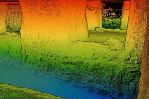
Exyn to open up to 3D mapping access with Stitch3D partnership
Exyn Technologies, a pioneer in multi-platform robotic autonomy for complex, GPS-denied environments, has announced a...
Read More
02 Jan 2024
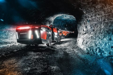
Amelia: the underground drilling conversation starter
Some 16 months after launch, Sandvik’s AutoMine® Concept Underground Drill, also known as ‘Amelia’, is...
Read More
28 Feb 2022
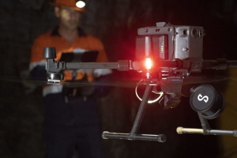
Emesent unveils ‘new standard’ in survey-grade autonomous LiDAR mapping
Emesent, today, unveiled Hovermap ST, the latest version of its leading Hovermap autonomy and mapping...
Read More
13 Jul 2020
Emesent takes drone autonomy to another level with AL2
Emesent says it has announced a major breakthrough in the journey to fully autonomous drone...
Read More