Tag Archives: Hovermap

South32 and Emesent collaborate on LiDAR-equipped Spot trials at Cannington

South32’s Cannington Mine, in Queensland, Australia, says it is supporting Emesent in its pursuit of developing and testing light detection and ranging (LiDAR) scanning and automation technologies in real underground mining environments.

The team from Emesent were recently on site at Cannington with Spot the Robot Dog, trialling Spot’s autonomy development and capabilities in the underground silver-lead mine.

While the technology is still in its research and development phase, it has the potential to guarantee safer outcomes and ultimately transform the way Cannington operates, South32 says. Mining work safety and productivity can be improved by deploying the autonomous capabilities of Spot in various potential scenarios with different data capturing tools, including scanning, video recording and heat sensing, it added.

The focus on site was testing Spot’s capability in ‘post blast re-entry’ scenarios and emergency response. Spot, with an integrated LiDAR scanner, autonomously navigated sections of the mine, travelling through uneven and wet ground without operator intervention and exploring unlit areas. It was able to produce a 3D Point Cloud map of the underground mine in the process, South32 said.

The Cannington team has previously worked with Emesent to help develop industry-leading technologies including its Hovermap System for underground scanning, which is now used in mines all over the world.

Emesent unveils ‘new standard’ in survey-grade autonomous LiDAR mapping

Emesent, today, unveiled Hovermap ST, the latest version of its leading Hovermap autonomy and mapping payload, at the SME MineXchange Conference & Expo in Salt Lake City, Utah.

The tough, lightweight, IP65 rated Hovermap ST includes Emesent’s new automated ground control feature.

This powerful combination is poised to set the standard for survey-grade autonomous LiDAR mapping in challenging environments, it said.

Since its 2019 launch, Hovermap, the company says, has made significant impacts in mining and other verticals, earning a reputation for its versatility, ease of use and mapping data quality. With thousands of hours of autonomous flight logged by customers around the world, it is the most proven LiDAR mapping and autonomy solution for challenging GPS-denied environments, Emesent claims.

Hovermap ST with the ground control feature builds on this reputation with significant improvements, allowing autonomous data capture in even harsher environments and for a wider range of use cases.

“We’re excited to be providing our customers with a new robust and reliable autonomous mapping tool for challenging environments, including those that were previously not well suited to SLAM-based mapping,” Emesent CEO and Co Founder Dr Stefan Hrabar, said.

Simultaneous localisation and mapping (SLAM) based systems have proved their value for rapid mapping of complex environments, but achieving survey grade accuracy and repeatability has been a challenge in some environments. Surveyors were faced with a compromise between fast data capture and data accuracy, depending on the job requirements, the company said.

“This is no longer the case with Hovermap ST and the automated ground control feature, as the feature enhances the SLAM solution to remove SLAM drift and produce survey grade, georeferenced point clouds,” Emesent said

“This is a huge step forward for mobile mapping, providing unrivaled SLAM accuracy and workflow efficiencies,” Dr Hrabar added.

Emesent ground control targets are placed in the environment and captured in a continuous scan with Hovermap ST. There is no need to stop or place Hovermap on the targets, ensuring the capture process remains as efficient as before. The targets are automatically detected by Emesent’s SLAM processing engine and used to both improve the SLAM result and automatically georeference the point cloud to the control points. The process includes automated constellation matching between detected targets and known survey coordinates, eliminating cumbersome manual work which can introduce errors.

Hovermap ST features a lightweight, IP65 weather sealed design, a powerful embedded computer for autonomy and mapping, and an accessory expansion port to further enhance its capabilities. The rotating LiDAR produces up to 600,000 points per second in dual return mode, covering a near spherical field of view.

Hovermap’s Tap-to-Fly autonomy feature enables Guided Exploration in previously inaccessible areas beyond line of sight and communication range. The omni-directional collision avoidance and smart Return-To-Home functions ensure assets are kept safe and valuable equipment isn’t damaged or lost, Emesent says.

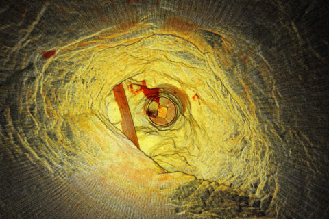
Emesent’s Hovermap aids ore pass decision making at Petra’s Finsch diamond mine

Highly accurate point cloud data sets from a Hovermap scan have allowed Petra Diamonds’ Finsch mine engineers to “see” the condition of ore passes for the first time and avoid an estimated five months and R5 million ($350,000) in remediation, Emesent says.

Finsch, in South Africa’s Northern Cape, uses ore passes and underground silos to transfer ore between levels or to redirect ore for load and haul to the surface. Blockages, hang-ups, overbreak or scaling can impact the structural integrity and result in extended downtime and significant remediation costs. Accurate imagery enables mine engineers to gauge the integrity of ore passes and plan timely and cost-effective remediation programs, according to Emesent.

Historically, however, scanning and mapping inaccessible shafts and voids has been a challenge for Petra.

The company’s management sought a means of obtaining accurate visualisations of underground voids, quickly and cost effectively, without endangering the safety of Petra personnel or contractors, Emesent says.

Petra management trialled the Hovermap multiple data capture methods with Emesent partner, Dwyka Mining Services, contracted to carry out multiple scans of an indoor stockpile, ore passes and vertical shafts, and a series of access tunnels and ramps.

Hovermap is a drone autonomy and LiDAR mapping payload. It uses the LiDAR data and advanced algorithms on-board, in real time, to provide reliable and accurate localisation and navigation without the need for GPS.

Dwyka spent a day on-site conducting a series of scans using Hovermap mounted to vehicles, a DJI drone, or lowered in a protective cage. Dwyka delivered point cloud data sets for Petra’s survey team to geo-reference and analyse, within 24 hours. It also provided visualisations of the ore passes, enabling the mine engineers to ‘see’ the condition of orepasses for the first time, Emesent said.

Alex Holder, Group Planning and Projects Lead at Petra Diamonds, explained: “We lowered Hovermap down ore passes, flew the drone into draw points and even scanned our shaft and ramps by fixing the scanner to one of our vehicles. The visualisation delivered exceeded all our expectations. The data captured in one ore pass saved us significant time and effort by confirming it was irreparable. That saved us millions.”

Using Hovermap led to an immediate decision to abandon plans to expend resources remediating a compromised ore shaft. This decision saved Petra an estimated five months and R5 million.

Heinrich Westermann, Mining Engineer at Petra Diamonds, said: “The ability to power and switch the Hovermap payload between the various applications meant that we were able to scan a considerable amount of the mine in one shift. Generally, this was either impossible and, if it were possible, it would take weeks to collect those datasets and months to see the final visuals.”

The data collected by Hovermap has become the basis of a data library for the site. It is augmented regularly and used to inform operational decision making by Petra’s mine planning and survey teams, according to Emesent.

Petra intends to deploy Hovermap scanning technology to map inaccessible locations at its other sites across Africa, Emesent says.

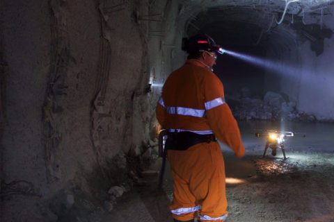
Emesent builds mining connections as Hovermap autonomy takes off

Having recently helped DJI’s M300 drone fly autonomously underground (through its Hovermap Autonomy Level 2 (AL2) solution) and signed an agreement with Deswik to provide surveyors and planners with more accurate data from inaccessible areas, Emesent has been on a roll of late. IM put some questions to CEO, Dr Stefan Hrabar, to find out more.

IM: First off, if no communications infrastructure is in place at an underground mine, how do Emesent’s drones stream a 3D map of the environment back to the operator’s tablet?

SH: Hovermap is smartly designed to operate beyond the communication range of the operator. The operator does not always need to see a live map since Hovermap is navigating by itself. The user can place a waypoint beyond the current limits of the map, and beyond line of sight and communication range. Hovermap self-navigates towards the waypoint, avoiding obstacles and building the map as it goes. Once it reaches the waypoint (or if the waypoint is impossible to reach), it automatically returns back to the operator. The map data is stored onboard Hovermap and when it returns back to within Wi-Fi range the new map data is uploaded to the tablet. The operator can then see the new areas that were mapped and place a new waypoint in or beyond that map, sending the drone back out again to explore further.

IM: What results have you so far received from using AL2 for Hovermap at mine sites? Were the results PYBAR got from trials at Dargues and Woodlawn in line with your expectations?

SH: Last year’s trials at Dargues and Woodlawn showcased some great outcomes for the PYBAR team, including the ability for Hovermap to capture valuable data using Autonomy Level 1 (AL1). The team saw great potential in the technology, leading to the purchase of two systems for their use. Earlier this year, AL2 flights were conducted at Dargues during the final pre-release testing phase. Even the first stope at Dargues that was mapped using AL2 highlighted the benefit of the system over traditional CMS (cavity monitoring systems). A large area of overbreak was identified in the Hovermap scan. The same stope had been mapped with a CMS, but this area was not visible from the CMS scan location so the overbreak was not identified.

A number of mines have been using AL2 to map their stopes and other areas beyond line-of-sight. With AL2, they can send Hovermap into places that previously would have been inaccessible, enabling them to obtain critical data in real time without risking the machine or personnel.

The AL2-based stope scans have been more detailed and complete (lack of shadowing) than ever before. A beyond line-of-sight flight down an ore pass was also conducted recently, with Hovermap guiding the drone down 120 m and returning safely to produce a very detailed scan.

The high level of autonomy provided by AL2 also allows remote operation of the drone. We recently completed a trans-continental demo, with a customer in South Africa operating a drone in Australia using our AL2 technology and standard remote collaboration tools. The remote operator in South Africa was able to use their laptop to experiment with the technology from the other side of the world, sending Hovermap exploring down a tunnel.

This is a taste of what’s to come, with drones underground being operated from the surface or from remote operation centres thousands of kilometers away. This will remove the need for skilled personnel on site, and reduce the time spent underground.

IM: What had been holding you back from achieving AL2 with drones/payloads? Is it the on-board computing power needed to that has been the issue?

SH: Flying underground where there is no GPS, the space is tight and there are hazards such as mesh, wires, dripping water and dust is very challenging. We overcame many of these with AL1, which makes it safe and easy for a pilot to operate the drone within line-of-sight (Hovermap provides collision avoidance, position hold and velocity control). AL1 has been deployed for 18 months with many customers around the world, clocking up thousands of hours of use. This helped to improve the robustness and reliability of the core flight capabilities.

Emesent CEO, Dr Stefan Hrabar

AL2 builds on this mission-proved base capability to provide additional features. AL2 allows the system to fly beyond line-of-sight and beyond commination range. This means it’s on its own with no help from the operator and needs to deal with any situation it comes across. There are many edge cases that need to be considered, addressed and thoroughly tested. A significant amount of effort was put into these areas to ensure Hovermap with AL2 is extremely robust in these challenging environments. For example, the drone downwash can kick up dust, blinding the LiDAR sensor. We’ve implemented a way to deal with this, to bring the drone home safely. Other considerations are returning in a safe and efficient way when the battery is running low, or what to do if waypoints cannot be reached.

IM: How do you anticipate your partnership with Deswik impacting the mine planning and survey process? Do you see this reducing the amount of time needed to carry out this work, as well as potentially cutting the costs associated with it? Have you already carried out work at mine sites that has proven these benefits?

SH: Our commitment is to help mining companies increase safety and production while reducing costs and downtime. We do this by providing surveyors and planners with more accurate data from inaccessible areas, allowing them to derive new insights. Our partnership with Deswik means we’re able to provide a more comprehensive end-to-end solution to the industry.

We see this as a very natural partnership that will improve the overall customer experience. Hovermap excels at capturing rich 3D data in all parts of the mine (whether drone based, hand-held, lowered down a shaft on a cable or vehicle mounted). Once the data is captured and converted to 3D, customers need to visualise and interrogate the data to derive insights. This is where Deswik and other mining software vendors come into play. They have powerful software tools for planning, survey, drill and blast, geotechnical mapping and a host of other applications. We’re partnering with these vendors to ensure seamless integration between Hovermap data and their tools. We’re working with them to build automated workflows to import, geo-reference, clean and trim the data, and convert it into formats that are suitable for various tasks.

Surveyors at Evolution Mining’s Mungari operation have been using this new process in Deswik. Previously they needed a third software tool to perform part of the workflow manually before importing to Dewik.CAD. The intermediate steps have been eliminated and others have been automated, reducing the time from more than 30 minutes per scan to five minutes per scan.

IM: Since really starting to catch on in the mining sector in the last five years, drones have gone from carrying out simple open-pit surveys and surveillance to drill and blasting reconciliation platforms to reconnaissance solutions carrying out some of the riskiest tasks in underground mining. In the next decade, how do you see them further evolving? What new tasks could drones carry out to improve safety, cut costs or increase productivity?

SH: Emesent’s vision is to drive forward the development of ‘Sentient Digital Twins’ of industrial sites to future-proof the world’s major industries, from mining to energy and construction. These industries will be able to move to more automated decision-making using high-quality, autonomously collected data across their sites and tapping into thousands of data points to make split-second decisions about potential dangers, opportunities and efficiencies using a centralised decision-making platform.

We see our Hovermap technology being a key enabler for this future. Drones and other autonomous systems will become an integral part of the mine of the future. Drones will be permanently stationed underground and operated remotely, ready for routine data collection flights or to be deployed as needed after an incident.

Hovermap is already addressing some of the biggest challenges in mining — including safety and operational downtime. It improves critical safety to mines, keeping workers away from hazardous environments while providing better data to inform safety related decisions such as the level of ground support needed. This then feeds into better efficiency by helping mines to more accurately calculate risks and opportunities, aid decision making and predict situations.

Hovermap can significantly reduce downtime after an incident. For example, it was used to assess the level of damage in LKAB’s Kiruna mine after a seismic event. More than 30 scans were captured covering 1.2 km of underground drives that were not safe to access due to fall of ground. In another case, one of our customers saved around A$20 million ($14.6 million) after an incident, as they could use Hovermap to quickly capture the data necessary to make a critical decision.

IM: In terms of R&D, what future payload developments are you investing in currently that may have applications in mining?

SH: We’ll keep adapting our Hovermap design to suit new LiDAR improvements as they are released. More importantly, we’ll improve the autonomy capabilities so that even more challenging areas can be mapped with ease. We’re also adding additional sensors such as cameras, as these provide additional insights not visible in the LiDAR data. Our colourisation solution is an add-on module for Hovermap, which uses GoPro video to add colour to the LiDAR scans. This allows the identification of geological and other features.

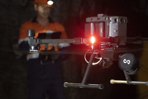
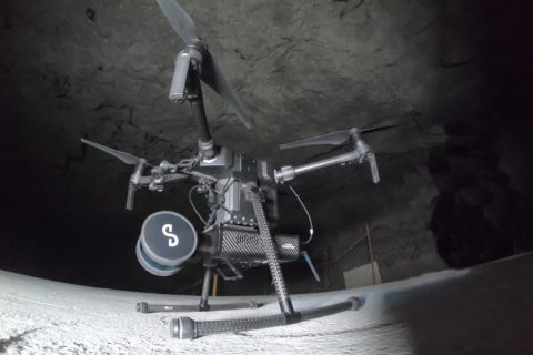
Emesent achieves ‘industry first’ flight with DJI drone

Emesent has allowed DJI’s M300 drone to fly autonomously underground in what it believes to be a world first for the platform.

The flights took place on August 4 at the Round Oak Minerals-owned Mt Colin copper mine in Cloncurry, Queensland, and were followed by similarly successful flights at another underground mine in north Queensland on August 13, Emesent said.

Emesent’s Hovermap LiDAR mapping and autonomy payload was used to add advanced autonomy to the newly launched DJI Matrice 300 RTK (M300). Coupling Hovermap with the M300 allows users to let the drone fly autonomously and safely into GPS-denied or inaccessible environments, such as densely packed warehouses, the undersides of bridges and in underground mines, Emesent says.

Mt Colin Mine Surveyor, Ashley Tibbles, said the Emesent technology would enable Round Oak to safely access complex locations quickly, and to a high degree of detail.

“Quality data has always been integral to safety and productivity in the underground mining sector,” Tibbles said. “The Hovermap provides an unparalleled platform to deliver this.”

Hovermap uses the LiDAR data and advanced algorithms on-board, in real time, to provide reliable and accurate localisation and navigation without the need for GPS, Emesent says.

Emesent CEO, Dr Stefan Hrabar, said the success of the underground flights with the Hovermap-enabled M300 will open up new possibilities for underground mines.

“The M300 is an excellent match for carrying Hovermap underground because of its flight endurance, IP rating, and ability to carry additional sensors such as cameras,” he said. “This will allow valuable data capture further into inaccessible areas of the mines.”

Dr Hrabar added: “Robust underground flight technology can significantly extend the capability of industrial drones and will deliver real benefits to the mining, construction and emergency response sectors.

“We’re looking forward to partnering with customers to help them derive competitive advantage from this breakthrough technology.”

Getac helps Emesent tackle mining’s underground mapping challenge

Getac’s V110 fully rugged convertible notebook has helped drone autonomy and mapping developer, Emesent, on its mission to provide mining customers with an all-inclusive solution to map unchartered territories in underground mines, the Taiwan-based company says.

Launched in November 2018, Emesent was on the lookout for a device able to withstand extreme mine conditions and to complement its Hovermap smart mobile scanning unit and drone, Getac explained.

“The harsh working conditions presented in underground mining meant that the device had to be rugged enough to withstand extreme environments, and be compact enough to be easily carried around,” it said.

This is where the Getac V110 convertible came in.

The rugged device can be used as a drone control platform thanks to several features, the company says.

“It can easily transform between a display notebook and a tablet computer, depending on where or when it is used,” it said.

“Additionally, its weight of 2.1 kg and dimension of 39 mm, makes it compact and lightweight enough for users to carry around without much effort.

“The V110 is also made from high quality magnesium alloy, with an advanced rugged polymer in areas of less impact and rubberised absorption polymer at the main points of contact, making it drop-resistant. The fully rugged convertible features a hot-swappable dual battery design, allowing for uninterrupted battery life. In addition to the key features, Getac’s V110 comes with a full-size waterproof membrane keyboard and red backlight, allowing users to type accurately even in the dimmest conditions. The device also features flash storage and responsive graphics, making it an excellent convertible notebook.”

With Getac’s V110, Emesent was able to provide mining companies with a rugged device that could complement its product operating in challenging environments, Getac said.

Dr Stefan Hrabar, CEO and Co-Founder of Emesent, said: “Safety and operational hazards at workplaces are important factors for mining companies, and we want to supply them with a comprehensive solution that not only enables them to operate but also improves efficiency without hassle.

“Harsh conditions in mining meant that we needed a device that was rugged enough and able to complement our smart mobile scanning unit. That is why we selected the Getac V110. Its ability to convert from laptop to tablet provides users the flexibility of both options. We also appreciate its hot-swappable dual-battery feature that enables users to process the LiDAR data underground regardless of whether they have access to power.”

Emesent’s Hovermap to provide Deswik with complete underground mine picture

Emesent has partnered with leading software developer Deswik to, it says, enable mining companies to incorporate high-quality data captured in inaccessible locations into their mine plans and surveys.

Emesent is a leader in drone autonomy, LiDAR mapping, and data analytics. Founded in 2018 through a spin out of CSIRO, Emesent has since built a reputation for delivering high-quality data capture in the mining, infrastructure, survey and mapping industries, it said.

The company’s Hovermap is a drone autonomy and LiDAR mapping payload. It uses the LiDAR data and advanced algorithms on-board, in real time, to provide reliable and accurate localisation and navigation without the need for GPS.

“This feature makes it ideally suited to map hazardous or underground environments where traditional data capture methods are difficult and dangerous,” the company said.

Deswik, meanwhile, is a global consulting and technology company delivering efficiency-focused solutions to all sectors within the mining industry. Its mine planning and management platforms are used in over 500 mine operations around the world.

The two organisations have signed a Memorandum of Understanding to integrate their solutions to provide a more comprehensive solution to the resources sector, Emesent said.

In the first instance, a co-designed, semi-automated workflow has been created to import Hovermap data into Deswik’s design and solids modelling platform, Deswik.CAD. This workflow enables users to translate the Hovermap data within minutes, creating usable surfaces, solids and point clouds for as-built surveys, volume reporting and design updates, Emesent said.

“The data from Emesent’s Hovermap scanner can be imported into Deswik and visualised using any of the attributes that have been captured in the scan,” Stephen Rowles, Deswik Survey Product Manager, said. “The scan can be filtered, modified, and clipped to suit the user’s requirements before being processed in one or more of the dedicated functions for point clouds.”

Emesent CEO, Dr Stefan Hrabar, said the two companies were committed to working together to help mining companies increase the value of their models, by providing surveyors and planners with more accurate data from inaccessible areas.

“We’re excited about collaborating with another market-leading technology vendor in the resources sector,” Dr Hrabar said. “Integrating our respective solutions will assist customers to boost productivity and improve outputs.”

Deswik Partner Manager, Patrick Doig, said recent global events had piqued customer interest in technologies that allowed technical teams to collect high-quality data without the need to be physically present on site.

A partnership between Deswik and Emesent empowers their mutual and future customers to simplify processes, gain additional efficiencies and make value add decisions to their operations, Doig added.