Tag Archives: GroundProbe

GroundProbe extends Americas mine, tailings dam monitoring reach with Santiago centre

GroundProbe has launched a dedicated monitoring centre in Santiago, Chile, to, it says, provide 24/7 real-time radar and laser monitoring services for tailings dams and mines throughout North and South America.

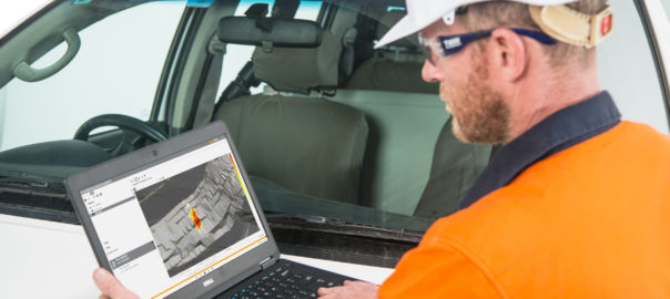
The centre connects remote sites with industry experts in three languages, according to GroundProbe, with the facility monitoring live slope stability data and reacting to alarms to ensure the maximum safety of people and communities.

Crewed by 45 specialised geotechnical engineers, these centre provide 24/7 expertise to over 30 customers globally, GroundProbe says.

GroundProbe, owned by Orica, is a global leader in real-time technologies used to detect instabilities and predict when mine and dam collapses will occur.

From a launch event in Santiago, GroundProbe CEO Brian Gillespie said the new centre marked an important step for GroundProbe’s future growth, especially for South and North America.

“We’ve witnessed a boom in Brazil for continuous, real-time monitoring of tailings dams, with a huge increase in demand for our remote, 24/7 geotechnical expertise,” Gillespie said.

“We saw it as an absolute necessity to bolster our offering and extend our support services from Asia Pacific to the Americas.

“Placing the centre in Santiago and ensuring its tri-lingual capabilities allows us to do just that.”

GroundProbe has, for many years, been providing 24/7 assistance to customers from its Asia-Pacific monitoring centre. The addition of a second location, operating in Spanish, Portuguese and English, sees GroundProbe remain at the forefront of our industry, the company said.

David Noon, COO of GroundProbe, said: “Our Santiago remote monitoring centre is operational from day one, with our teams already monitoring many tailings dams, a massive hydro-electric dam and even a landslide on a national highway in Colombia.

“Not only is it essential to our customers that our team are native Spanish and Portuguese speakers, but having a centre in Latin America shows our level of commitment to the region and to creating jobs in the local communities we serve.”

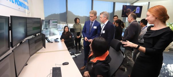
To mark the launch, GroundProbe and Orica hosted an event with key customers, industry representatives and stakeholders (pictured).

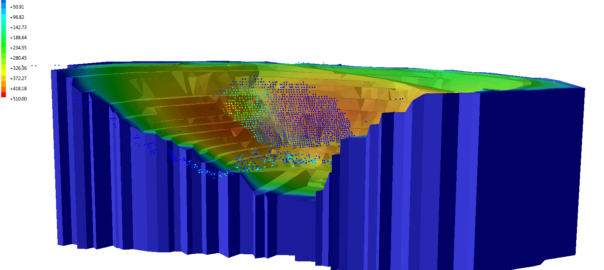
GroundProbe’s monitoring centres are home to its Geotechnical Support Services (GSS) team and dedicated team of geotechnical support engineers.

The second monitoring centre in Santiago will provide the same services to customers, including: GSS-Remote, a 24-hour remote monitoring solution; GSS-Training, a SSR and laser training service; and GSS-Reporting, the company’s customised analysis and reporting service.

Rocscience and GroundProbe launch two-way integration

Rocscience and GroundProbe have launched a collaboration between their industry-leading software systems, to provide greater value to the global geotechnical community, the two companies said.

As part of Rocscience’s new release of its slope stability programmes, Slide3 and RS3, deformation output from any of GroundProbe’s Slope Stability Radars or lasers systems can be imported into the programmes.

This data can then be automatically visualised with the geotechnical model, inclusive of Factor of Safety heatmaps and Probability of Failure models.

Users of GroundProbe’s SSR Viewer software will be able to import Slide3’s 3D failure model as a layer, allowing the model to be overlayed with real-time deformation data, in addition with the Factor of Safety maps.

“This is an innovative step and industry first, with the exchange of data being two-ways between the systems,” said Lachlan Campbell, GroundProbe’s VP Marketing and Innovation.

“Having the data flowing two-ways between a geotechnical modelling package and a geotechnical monitoring package means engineers can perform a deep-dive analysis in either software.

“A user could verify their geotechnical model assumptions with the radar data overlaid in Slide3, whilst another could be using the geotechnical model in a real-time monitoring system to see the spatial changes in deformation over time.”

As announced by Rocscience, the partnership between GroundProbe and it will benefit both companies as well as the wider geotechnical engineer community by allowing for the readily accessible exchange of data between software platforms.

Rocscience said the collaboration between companies and software systems will enable geotechnical engineers to analyse and solve problems more effectively by allowing for the direct comparison of modelling and monitoring data on a single display.

Rocscience specialises in developing both 2D and 3D software for use by geotechnical engineers across the civil and mining industries.

Slide3, their 3D geotechnical modelling package (formerly “Slide³”) was first introduced in 2017.

The Slide3 platform allows geotechnical engineers to calculate the factor of safety of complex 3D slope stability geometries that 2D models cannot fully simulate. It also allows for the modelling of advanced geometries like landslides, MSE walls, slopes supported by soil nails, and more.

With Slide3, users can calculate failures in any direction without the need for defining the direction in advance, increasing efficiency in modelling and analysis.

GroundProbe is a leader in the development and supply of advanced technology solutions to the mining and civil industries. SSR-Viewer is the common software across all GroundProbe monitoring solutions.

It processes the complex data that our systems collect and makes it easily understood, allowing its users to view movement, understand when it becomes a problem and predict the time of failure.

The partnership between the two companies, and the integration between their software packages, gives geotechnical engineers around the globe the most sophisticated of slope stability analysis tools.

GroundProbe brings new features and functionality to SSR-Viewer 9

GroundProbe has released a new version of its SSR-Viewer software that comes with a powerful engine to “revolutionise” 3D data visualisation across its entire suite of Slope Stability Radars and lasers, according to the company.

CEO John Beevers said the release brings a host of new features and functionality to its “market-leading platform, many of them developed in collaboration with our customers”.

The SSR-Viewer 9 release features two new analysis tools, the possibility of visualising 2D radar data in 3D, drag and drop external layers and structures, and alarm threshold visualisation, among other developments.

The latest release supports all GroundProbe Series-2 and Series-3 radar technologies – 3D real aperture radar, 2D real aperture radar and 2D synthetic aperture radar – and both of the company’s new LiDAR-based technologies, the Geotech Monitoring Station (GMS) and Geotech Monitoring LiDAR (GML).

“All the features and benefits of SSR-Viewer that our long-serving radar customers have been accustomed to – such as its intuitive visualisations, industry-leading analysis tools and powerful reporting – are now also available for our LiDAR-based solutions,” GroundProbe said.

The 2D radar data visualisation in 3D allows SSR-FX and SSR-SARx users to view data in the new DTM (digital terrain map) View visualisation, as well as in the existing Plan View visualisation.

“In both, the deformation heatmap is overlayed on top of the scene, and users can switch between the two visualisations. To visualise the 2D data in 3D, users simply import their mine site DTM and align the radar data with it,” GroundProbe said.

“The two are snapped together ready for viewing and analysis. Once the DTM is imported, the radar data is automatically geo-referenced.”

For SSR-XT users, the 3D visualisation functionality has been “significantly improved”, the company said.

“The radar still automatically generates a powerful, high-density 3D model of the wall, live, with every scan. But SSR-XT users now have the flexibility of optionally importing a mine DTM for a holistic view of the entire site.

“Across all our radars, the new DTM feature also allows users to drag and drop external models, geology layers and structures, with geo-referencing built in. Data layers, such as the data point cloud, radar point cloud and enhanced deformation masks can be switched on and off to suit the user.”

The two new analysis tools are called Forecast and Spot Velocity.

Forecast allows users to estimate the time of collapse using inverse velocity theory, with users able to add a forecast prediction, in-chart, to easily visualise when the plot reaches zero and, hence, the time of collapse.

Spot Velocity, meanwhile, gives users the rate of change between two points in time with the click of a button. It gives the user not only the rate of change, but also the delta time and delta measurements.

And, the alarm threshold visualisation tool – available for all alarm types – comes on a ‘banded window’ on the corresponding analysis chart. When an alarm is defined, the threshold is visualised in the charts using a banded window of three colours.

“Green areas show when an alarm isn’t triggering, while the red and orange areas highlight when the alarm will trigger, allowing for an early indication of when an alarm is approaching,” the company said.

Alarm thresholds are also a powerful back analysis tool, GroundProbe says. Site specific alarm thresholds can be generated from back analysis and an iterative approach towards the application of alarms can be adopted.

SSR-Viewer 9 also has the option of a single or double view on SSR-XT, GMS and GML devices, and increased levels of support with WebUpload.