Tag Archives: Christopher Clark

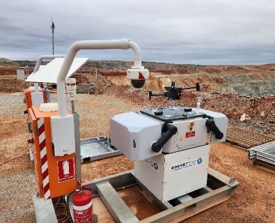
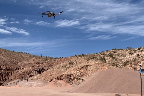
RocketDNA Ltd seals first autonomous xBot contract with Calidus Resources subsidiary

RocketDNA Ltd (RKT), a global drones-as-a-service provider, says it has signed its first long-term contract for an autonomous xBot® solution with Keras (Pilbara) Gold Pty Ltd, a subsidiary of Calidus Resources Limited.

The contract will see the provision by RKT of an autonomous xBot solution, which includes:

  • Supply and maintenance of one xBot drone-in-a-box surveying system (SurveyBot®). The SurveyBot is a site-ready, integrated hardware system that supports a surveying drone which is monitored by a pilot located at an off-site remote operating centre (ROC). It is built to meet the stringent requirements of the national aviation safety regulator (Civil Aviation Safety Authority (CASA)) and includes DJI drone hardware, communications systems (ethernet, Wi-Fi, cellular & Starlink connectivity), power management system, weather station and CCTV;
  • Remote operation of the SurveyBot from RocketDNA’s ROCs in Perth and Adelaide. RKT will provide a pilot operating under its CASA-approved deployment and operational risk methodology and policies, allowing the customer to focus on data outputs and insights rather than drone flying. RKT leverages significant cost savings from the ability to manage multiple xBots from a single office site with low travel and site safety overhead;
  • Strayos AI software licence to enable automated processing, analysis and reporting for the open-pit operations using the SurveyBot data. RKT operates a commercial partnership with Strayos which provides mining operators with an array of AI-driven data applications that generate operational efficiencies and insights; and
  • RocketDNA SiteTube® data visualisation platform. SiteTube is RKT’s proprietary data visualisation platform, allowing enterprise customers to host & access their data securely on locally-based cloud servers.

The SurveyBot system will initially be deployed at Calidus’ Blue Bar pit, a satellite open-pit operation that is 70 km by unsealed road from Calidus’ Warrawoona gold project in Western Australia and 25 km south of the township of Marble Bar, in Western Australia. The surveys provided will include:

  • Daily surveys of the open pit for drill and blast design, pit conformance reporting, volumetric reporting;
  • Stockpile surveys for volumetric reporting;
  • Daily imagery and video to provide up-to-date situational awareness of the operation to the clients’ off-site personnel; and
  • Ability for live-streaming of video

The overall solution is expected to generate significant operational efficiencies for the customer including:

  • Reducing the frequency of physical surveying activity, which requires significant road travel and on-site time;
  • Leveraging rapid data processing time and AI insights for mine optimisation; and
  • Providing oversight of mining operations to remote senior management

Calidus Resources Managing Director, David Reeves, said: “Calidus is currently commencing operations at various satellite pits that are up to 70 km distance from our main processing facility. The pits are generally smaller in size and do not justify their own survey team on site. The xBot not only allows daily pickups for survey to be completed efficiently, the associated video also allows our planning team in Perth to understand exactly how the operations are progressing and allow for rapid reaction if required.

“We look forward to partnering with RocketDNA and see great potential for this technology on our other sites as they come on line”

RocketDNA CEO, Christopher Clark, said: “We are delighted to announce this first long-term xBot contract. Although we already have other xBots deployed, the long-term format of this contract will allow us to partner with the customer and potentially provide for further specific needs of the site. The components within this specific contract also demonstrate the breadth of our product suite – and how the different components of XBot, ROC, Strayos and SiteTube can be harnessed to provide an overall solution which is cost effective and value adding for the customer.”

The three-year contact (monthly billing) is conditional on RocketDNA gaining area approval by the CASA. RKT has in place broad CASA approval for autonomous and beyond visual line of sight (BVLOS) drone operations, however, under Australian legislation, further authorisation is also required at the project level to attach additional areas of operations to our current approval. RKT anticipates no impediments in achieving this step.

RKT is currently completing the assembly of its first batch of five xBots from in-stock components, one of which has been allocated to Calidus. After safety reviews and on-site preparation, it will be commissioned within the next 3 months, considering the CASA approvals mentioned above.

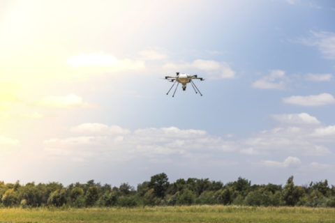
Delta Drone and Strayos team up to improve mine site decision making

Drone-based data provider, Delta Drone International Limited, has announced a new product addition to its data solutions business model via its partnership and distribution agreement with AirZaar Inc, a corporation doing business as US-based, mining-focused software provider Strayos.

The arrangement will allow DLT to distribute software licences across Africa and Australia, either directly or via resellers and consultants. DLT will apply the solution in an integrated way
for existing and new customers to process and value-add drone captured data. In addition, customers will gain extra value from the Strayos platform more broadly, given its multi functionality to generate ongoing operational insights across business operations.

DLT CEO, Christopher Clark, said: “We have been assessing the markets in which we predominantly operate, being Australia and Africa, and have identified that our customers want a stronger vertically integrated solution that not only includes data capture but also data insights. Overlaying AI-intelligence in our current data workflows adds a higher value proposition to the end user, resulting in faster turnaround of reporting and ultimately simplifying decision making within these complex environments.”

Clark said the partnership with Strayos was mutually beneficial, with Delta Drone International seeing an increased revenue mix of software sales while Strayos would leverage the drone-focused provider’s global presence and geospatial experience “to ensure customers receive seamless on-boarding and continuous support”.

Strayos, Delta Drone says, has developed a unique software platform with advanced image processing, digitalisation and artificial intelligence tools designed to improve safety, efficiency and productivity in mining job sites.

DLT added: “Strayos’ software is primarily data-enabled by aerial imagery and LiDAR, captured by drones, and used to create digital twins of sites. The digital twins can be further enhanced by adding data from additional sensors from mining equipment. Strayos AI generates insights that help mining management and engineers make faster more informed decisions and ensure conformance across their operations.”

Strayos CEO, Ravi Sahu, said: “By partnering with Delta Drone, customers in Africa and Australia will be able to take advantage of Strayos’ AI powered solutions and insights to optimise their operations for safety, sustainability and productivity from mine to mill. Delta Drone is an excellent partner for this market expansion as they can immediately expand the products and value add they offer to their current customers and are well-positioned to support new customers.

“Working with Delta Drone is the beginning of an exciting new chapter in making advanced AI solutions easily available to the mining industry.”

Delta Drone to carry out survey mapping and blast inspection services for Assmang’s Khumani mine

Global drones-as-a-service provider, Delta Drone International Limited, says it has signed a contract with Assmang Proprietary Limited for drone surveying services at its Khumani iron ore mine in the Northern Cape Province of South Africa.

The contract, which is through Delta Drone subsidiary Rocketmine Pty Ltd, is for a three-year renewal and has a Total Contract Value of A$880,000 ($609,740).

Drone services will include survey mapping and blast inspections for Khumani – formerly known as the Bruce, King and Mokaning (BKM) Project, which refers to the farms on which the iron ore resources are located. The mine has a capacity to mine 14 Mt/y of iron ore, according to Assmang.

DLT CEO, Christopher Clark, said: “We are very pleased to have renewed our services for a further three years with Khumani mine who are a leading player in the iron ore mining sector.”

Delta Drone to provide aerial support to Red 5 at KOTH, Darlot

Global drones-as-a-service provider, Delta Drone International Limited, says it has signed a contract with Red 5 Limited (via wholly owned subsidiary) in Western Australia for drone surveying services.

The contract with Greenstone Resources (WA) Pty Ltd is for three years and has a total contract value of A$1.01 million ($725,581) and annual recurring revenue of A$336,000 (billed monthly). Services are for the King of the Hills Mine (KOTH) and Darlot Mine, both in the Eastern Goldfields.

Red 5 owns and operates the KOTH gold project, a mine that is scheduled to produce 176,000 oz/y of gold over the first six years of its life. Darlot is an underground satellite mine to the KOTH Processing Hub (pictured).

Delta Drone International CEO, Christopher Clark, said: “We are pleased to be officially working with Red 5 and to provide frequent aerial surveying support which can be delivered efficiently and effectively to the business across a number of areas including for open pit mining, stockpile, processing area and for environmental purposes.”

Christian Viguié, CEO of Delta Drone SA, said this was the first major contract the company had signed in Australia, validating the success of its implementation and ability to duplicate the model that made Rocketmine successfully leveraged in southern Africa.

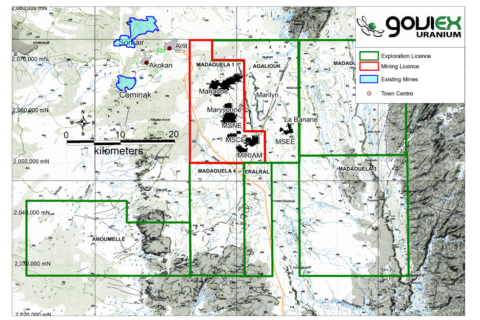
Delta Drone to perform virtual 3D model baseline survey for GoviEx at Madaouela

Delta Drone International is set to enter the Niger market for the first time after being contracted by uranium explorer and developer, GoviEx Uranium, to perform a virtual 3D model baseline survey for GoviEx’s Madaouela project.

The baseline survey will be one of the first times Delta Drone International uses its advanced surveying and data capture technology to create a shareable view of a potential mining site to share with GoviEx Uranium stakeholders, it said. These stakeholders are currently unable to attend the site due to current travel restrictions, while the engineering teams will use the results for project construction design.

Over a two-week period, Delta Drone International’s specialist mining pilots will deploy state-of-the-art surveying drones, with the data captured to be used by GoviEx Uranium as the base to build a virtual 3D model of the new site and consult with key international stakeholders, virtually, it said.

Delta Drone International CEO, Christopher Clark, said: “This is the first time Delta Drone International has been commissioned for a project in Niger – a region where aviation, including drone operation, requires military clearance. This project with GoviEx Uranium is an example of the many ways drones are being used to more efficiently share the data needed to guide decision making among business leaders.”

He added: “Working with the GoviEx Uranium team right from the planning phase of their new mine ensures we can seamlessly collate multiple data sets of areas where low-quality, outdated or even no data is available, export it into easy-to-utilise formats and virtually share with their international stakeholders – removing the need for on-site attendance. This type of data capture is likely to be increasingly used in remote sites to support much more efficient and timely stakeholder engagement and decision making around key milestones in projects.”

An updated prefeasibility study from February on Madaouela, based on probable mineral reserves of 54.7 Mlb of U3O8, indicated the company could build a 1 Mt/y operation able to produce 2.48 MIb of U3O8 for 20 years from mostly open-pit reserves.

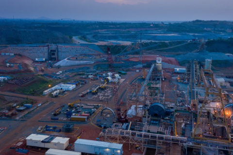
Delta Drone to fly UAV-based LiDAR units at Newmont’s Ahafo gold mine

Global drones-as-a-service provider Delta Drone International says it has been re-appointed by Newmont Ghana Gold Ltd, a subsidiary Newmont in Ghana, for a light detection and ranging (LiDAR) project on its Ahafo mine.

Delta Drone International will provide a drone-based LiDAR solution to create an accurate 3D model of the earth and its surface characteristics to map new areas for the mine and mitigate potential risks prior to mine expansion construction commencing, the company says.

Delta Drone International CEO, Christopher Clark, said: “To continue working with Newmont Corporation, one of the world’s leading enterprise gold mining companies, who is using advanced drone techniques for several types of project applications, is a testament to our specialist expertise and drones-as-a-service model.”

He added: “Using the latest in drone LiDAR technology, we can fly with this sensor in a fixed-wing drone, allowing us to map new areas and essentially compete with manned LiDAR, but at a lower price point.

“We are seeing increased demand to use our LiDAR capability to create ‘digital elevation models’ that allows companies to see below thick forest and other surface vegetation and more accurately determine site suitability for certain types of infrastructure and how a site can be used.”