Tag Archives: tailings dam monitoring

Skycatch maps out autonomous mining future with DJI M300 mapping, analytics solution

San Francisco-based Skycatch has been making waves in the drone space with a range of mapping solutions tailored for mining applications but, according to Chief Technology Officer, David Chen, it thinks of itself as a “software-first company”.

He explained to IM: “We are really a computer vision company, and we focus on building not only the drone solution, but the software that enables it.”

This sees the company provide data capture automation, processing, visualisation and analysis tools to the industry for efficient decision making.

Chen added: “We work with a number of the top mining companies across the globe, providing them with unique solutions that they are using every day to complement their existing survey processes.”

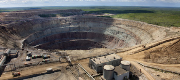
The company, which has become a leader in highwall mapping through these solutions, is expanding beyond surveys into other areas.

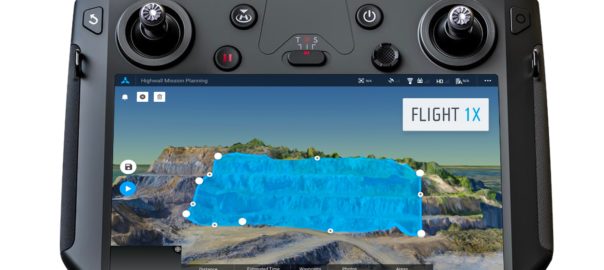
This will be facilitated through software like its Flight1X, a cloud-based solution designed specifically for the recently launched DJI M300 drone that, Skycatch says, delivers unprecedented drone mapping accuracy and inspection automation for operations like mines. The proprietary software offers the most complete end-to-end high precision industrial drone capabilities available today, according to the company.

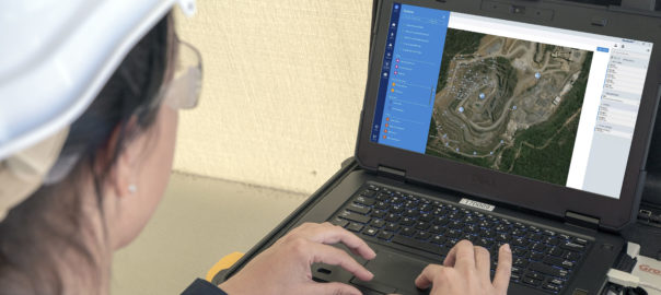
Flight1X, launched at MINExpo 2021 today, comes with proven data and network security via Skycatch servers in the USA, with the Android-based flight planning application running on the M300 Smart Controller. When combined with Datahub, Skycatch’s cloud-based solution, the pair offer mission planning and data visualisation.

Chen expanded on some of these capabilities.

“The majority of drone software out there has been focused on 2D mapping, whereas we have seen that mining, which comes with dynamic and undulating terrain, requires something different.

“What we are building is an automated mission planner where the primary view is of 3D terrain. This planner allows you to bring in existing terrain data from elsewhere or capture and process data from our own platform. The user can then rotate around this map and see the exact mission profile in 3D for improved visualisation and decision making.”

This data integration piece, which hinges on the cloud-based Flight1X platform, could provide Skycatch with an ‘in’ to the tailings dam monitoring market.

“While we’re already providing some survey solutions for tailings dams, the combination of high precision survey (with cm-level precision) for dam movements, fully automated section missions based on RGB and thermal imaging, and machine learning could provide data on dam seepage, for instance,” Chen said.

“We also want to integrate IoT sensors around dam movement and other areas into this cloud-based platform to provide an overall view of the tailings management facility.”

Skycatch is currently working on integrating the DJI M300 and L1 & P1 sensors – purpose built for mapping and surveying – into its offering, with Chen seeing the process as just the next stage in facilitating the autonomous mine of the future.

“The one thing that fully autonomous mines need is a map of the mine for these autonomous machines to operate off,” he said. “We have a focus on making data more accurate, accessible and faster; making it faster is the key for fully autonomous mining.

“Right now, with the current photogrammetry process, it’s still: capture, process and wait a few hours for a map. To be fully autonomous, you need that dynamic map in near real time, which is what we can offer the industry.”

ALROSA shores up tailings dump safety with automated wireless monitoring

ALROSA says it has approved the introduction of automated wireless monitoring systems at the hydraulic structures of its tailings dumps as it looks to further reduce the risk of emergencies, improve operational safety of the structures and facilitate the accumulation of data on their operations for future analysis.

The automated wireless monitoring system (AWMS) consists of a network of sensors installed at the existing observation wells of the hydraulic structures (HS) at tailings dumps, and serve to provide early warnings in case of deviation from safe parameters, the diamond-focused company said.

The system monitors all key parameters of a hydraulic structure, including water levels in open reservoirs, water pressure in wells and soil temperature.

Konstantin Kolegov, ALROSA’s Deputy Chief Engineer for Hydraulic Structures, said: “Industrial and environmental safety is our top priority. The company’s dedicated units gather the HS data according to the schedule. The AWMS minimises the human error factor and reduces the risk of emergencies at HS, including tailings dumps and hydraulic power systems, as it can send real-time alerts of changes in key parameters. Moreover, the system, which was first introduced last year at Aikhal Division, will help accumulating and analysing data on the condition of hydraulic structures to optimise their performance.”

Cutting-edge technologies provide an opportunity to source the necessary information much faster and frequent compared with manual monitoring, ALROSA said. Thanks to the Manufacturing Execution System integration, the collected data will become available to all required personnel in the company.

During the first stage of implementation in 2020, the equipment was installed and commissioned at the tailings dump of processing plant No. 14 at Aikhal Division. Stage two provides for the AWMS to be installed at two tailings dumps of processing plant No. 12 of Udachny Division in 2021, and at two facilities of Nyurba and Mirny (open pit, pictured) Divisions in 2022. Following this, the system will be expanded to include the remaining hydraulic structures in Mirny, Udachny, Aikhal and Nakyn.

Total investments during the two stages are estimated at around RUB 100 million ($1.3 million), ALROSA said.

Worldsensing to offer up IoT wireless monitoring expertise to Brazil miners

Worldsensing says it has joined the Brazilian Mining Association (Instituto Brasileiro de Mineração, or IBRAM) to help establish a favourable environment for mining business, competitiveness and development.

In particular, Worldsensing is hoping to extend the use of its remote, real-time data collection, monitoring and management systems to ensure greater safety and efficiency in Brazilian mining operations, it said. These systems are used in mines around the world from Sweden to Chile.

Through its Loadsensing product family, Worldsensing offers a range of wireless data acquisition technology aimed at enabling remote data collection in hard-to-access environments, predictive maintenance, reducing monitoring costs, ensuring workforce safety and managing environmental risks.

The wireless systems can be used for monitoring surface areas, tailings dams, leach pads and slope stability, as well as in deep excavations without line of sight.

Last month, the company joined up with IDS GeoRadar, a Hexagon company, to launch what they say is the most comprehensive mine safety monitoring system to date using Worldsensing’s Loadsensing IoT-based wireless monitoring platform.

Steve Cahill, Worldsensing’s Chief Operating Officer, said: “Our focus is on improving safety, which we know is also a top priority for Brazil’s mining industry. We see our membership of IBRAM as being central to developing relationships that can further this mission.”

Worldsensing has a long history of involvement in the Brazil mining sector and, in May 2019, the company’s Loadsensing product family was certified by Brazil’s National Agency for Telecommunications.

GroundProbe aggregates geotechnical data with MonitorIQ

GroundProbe says it has launched a new data aggregation software for geotechnical sensor monitoring, MonitorIQ.

MonitorIQ is, according to the Orica-owned company, feature-rich allowing users to collate and compare data from more than 120 sensor types on one platform including the suite of radar, laser and vibration monitors provided by GroundProbe. It also allows users to compare data from prisms, piezometers, drones, temperature readers, air pressure measurement, and many other sensor types.

The all-new software can also consolidate data across multiple sites be they mines, tailings dams, natural landscape hazards or other built structures, according to the company.

“Through the centralisation of all monitoring data into one dashboard and analysis platform, MonitorIQ revolutionises how users consolidate sensor data to correlate and identify trends, ensuring confident decision making,” GroundProbe said.

Brian Gillespie, GroundProbe’s CEO, said the development of MonitorIQ is the result of its customers using many different sensors to gather various types of information.

GroundProbe said: “More than just a data aggregation platform, MonitorIQ comes built-for-purpose with GroundProbe’s patented geotechnical analysis software, SSR-Viewer, fully embedded.

“This gives users the freedom to access SSR-Viewer’s all-inclusive suite of visualisations and safety-critical charting and alarming tools, on-the-fly, direct from MonitorIQ.”

GroundProbe is part of Orica Monitor – a newly formed division of Orica – dedicated to providing advanced monitoring technology solutions across both the mining and civil industries. MonitorIQ, meanwhile, is the latest addition to Orica’s suite of leading digital technology solutions.

Lachlan Campbell, GroundProbe’s VP of Marketing and Technology, said: “MonitorIQ completely eliminates the need for users to switch between multiple platforms when working with any data collected on-site. This combined with SSR-Viewer’s deep dive analysis capability presents an interface that is integrated and intuitive.”

He added: “Safety has been and always will be our number one priority, and this solution will ensure efficient and effective decision-making to provide maximum safety.”

James Usherwood, Product Manager for MonitorIQ, said: “MonitorIQ has definitely transformed the way we view, interact and report on data. Where MonitorIQ will go in the future will definitely change the way the mining and civil construction sectors monitor hazardous areas.”

MonitorIQ is currently being rolled out globally across the GroundProbe customer network, which spans 30 countries.