Tag Archives: LiDAR

BHP’s Jurgens presents big picture automation plan

Diane Jurgens, BHP’s Chief Technology Officer, used her time on stage at the Bank of America Merrill Lynch SmartMine conference, in London, to highlight the company’s plan to introduce full or partial automation across its entire value chain.

The miner has already introduced automation across many of its operations – from haul trucks at Jimblebar (Western Australia) to drill rigs at Western Australia Iron Ore – but Jurgens said the company has bigger automated plans.

This includes considering opportunities to accelerate truck autonomy across the company’s Australia and Minerals Americas sites – the company previously detailed plans to automate around 500 haul trucks across its Western Australia Iron Ore and Queensland Coal sites – and introducing “Decision Automation” to link autonomous processes and data from different sources together to create “near instantaneous, optimised decision making”, Jurgens said.

While she talked up the use of automation in mining – referencing the experience she has in the automotive and aerospace industries – she admitted full automation across the BHP group was unlikely.

“This is because we automate equipment and processes where it provides the highest value,” she said, explaining that investment in technology competes against all of other projects in the BHP portfolio, “and alternative uses of cash, under BHP’s Capital Allocation Framework”.

To test this, the company has built proving grounds at two active mine sites (Eastern Ridge in Australia and Escondida in Chile) to trial new innovations in geology, extraction and processes, and “develop workforce capability so that our people are equipped for the rapid pace of change that lies ahead”, Jurgens said.

Just some of the new innovations Jurgens mentioned included the use of advanced geophysics modelling to reanalyse existing drilling data. This new approach led, in November last year, to the Oak Dam copper discovery, near its existing Olympic Dam operations in South Australia.

Recently, sensors were installed at the Escondida test grounds to prototype the use of real-time data to analyse the quality and grade of ores and inform, for example, whether to divert unprocessed ore for leaching, to concentrators or waste. Jurgens said: “The key to achieving this is using data collected through the sensors and combining it with proprietary algorithms. We then apply our knowledge of the ore body to optimise the processing methods. Once in production, we expect these to improve throughput performance.”

With access to more detailed data on extracted material, machine algorithms can automate decisions to identify and divert waste, which increases plant performance and reduces processing costs, she added.

New patented leaching technologies have, meanwhile, increased metal recoveries by 10-12% and shortened the processing time by 50%, according to Jurgens. “At Spence in Chile we increased copper recoveries by about 10% and helped offset grade decline through implementing the low-cost Spence Recovery Optimisation project,” she said. “The initiative improved heap leach kinetics which meant we could maximise utilisation of the leach pads and therefore use the full 200,000 t of tankhouse capacity.”

This breakthrough also informed the successful heap leach trial at Olympic Dam, which the company has just completed.

The company’s automation and innovation journey has already resulted in significant wins, according to Jurgens.
Equipment automation is creating more efficient, standardised and safer operations, she said:

  • Autonomous blast hole drills across BHP’s Western Australia Iron Ore assets have increased drill rates by 25%, and reduced monthly drill maintenance costs by over 40%;
  • Haulage automation at the Jimblebar operation, in the Pilbara, has reduced heavy vehicle safety incidents by 80%;
  • Machine learning is being applied to maintenance on trucks in iron ore and coal – to analyse component failure history;
  • At Yandi, haul truck maintenance analytics increased truck availability to above 90% and generated recurrent cost savings. Replicating these strategies to our trucks in energy coal in the Hunter Valley, BHP has also seen an increase in truck availability;
  • Automating key components of BHP’s rail network is supporting increased capacity, more reliable dispatch and improved maintenance outcomes;
  • In Western Australia, material density scanning and laser precision have delivered an additional 2.4 t of iron ore per car while reducing safety risks of overloading;
  • The automated rail network scheduling system, which controls over 10,000 ore cars and transports about 270 Mt/y of iron ore, is becoming more effective through self-learning algorithms, ensuring trains arrive at port, on-time, and;
  • LiDAR technologies are being used to automate the loading of ships that transport BHP’s product to customers around the world.

Clearpath survey robots receive value added LiDAR capability

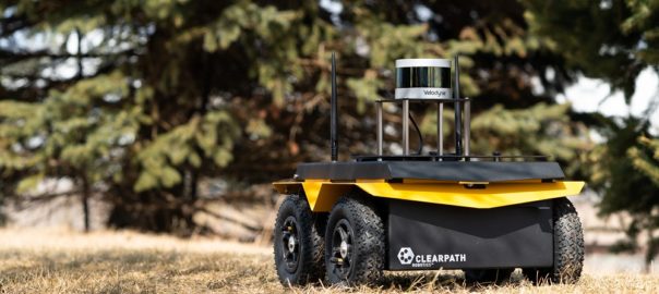
Velodyne Lidar says the combination of its LiDAR sensor expertise with Clearpath Robotics’ mobile robots for survey and inspection will offer customers a “value-added” service, allowing them to get maximum value from the high-resolution, 3D data these machines capture.

Clearpath’s robotic solutions now use Velodyne’s state-of-the-art LiDAR technology, which, Velodyne said, boasts industry-leading resolution, range, and field of view. “Velodyne sensors create a 360° real-time map of the environment, allowing the robot to detect and avoid obstacles for safe autonomous navigation,” the company said.

Julian Ware, General Manager of Clearpath Robotics, said: “We have been recommending and integrating Velodyne products on our robotic platforms for almost a decade. Velodyne sensors have proven to handle challenging automation tasks and flawlessly function in unfamiliar and unpredictable settings.”

Velodyne’s LiDAR sensors are designed for seamless integration with robotic platforms by being easy to mount, having low-power consumption, and including a web configuration tool, the company said. “They are meticulously designed to perform in high-stress environmental conditions like inclement weather, which is essential for outdoor deployments.

“Clearpath provides value-added services for Velodyne with wide-ranging expertise integrating its sensors in customised robotics systems. The company has extensive experience supporting Robot Operating System (ROS)-ready mobile robotics platforms by developing and maintaining ROS drivers, and providing step-by-step ROS tutorials.”

Mike Jellen, President and CCO, Velodyne Lidar, said: “Clearpath brings the skill set and experience necessary to help customers derive maximum value from high-resolution, 3D data provided by Velodyne Lidar to create innovative ground-based mobile robot solutions.”

Clearpath Robotics provides hardware, software, and services to enable self-driving vehicle development, deployment, and operation, serving markets that span industrial materials handling, mining, military, agriculture, aerospace, and academia.

LiDAR proves up potential new resource at Kingston’s Misima gold project

A recent LiDAR survey has confirmed the location of a large stockpile of mineralised material at Kingston Resources’ Misima gold project in Papua New Guinea.

The light detection and ranging (LiDAR) survey provided a highly accurate and detailed model of the surface terrain, which has assisted in identifying historical mining topography, current and historic artisanal mining, as well as identifying potential geological features and determining water drainage patterns, Kingston said.

This near-surface stockpile is not accounted for in the current 2.8 Moz indicated and inferred gold resource at Misima, according to the company.

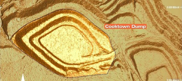
“This information will assist and enhance the broader drilling and exploration programme,” Kingston said. “A stockpile of mineralised material left in place by former owner Placer Dome (since acquired by Barrick Gold) has been confirmed at the Cooktown Dump, a large area adjacent to the Tonowak Pit reported to contain 3.6 Mt of low-grade material averaging 0.5 g/t to 0.7 g/t Au.”

This dump, which was capped with topsoil and rehabilitated during the closure process, remains intact, with its current position matched against mine survey files created during mine closure, according to Kingston.

“While the grade of the Cooktown Dump is modest, it is important to note that it represents loose rock, at surface and close to the likely location of a future processing plant,” Kingston said. “All of these factors reduce mining and processing costs.”

By calculating the volume of the Cooktown Dump LiDAR model and cross-referencing this against Placer’s Mine Closure Plan and survey files from 2000 to 2004, the company has set an exploration target for the dump of 3.6 Mt at 0.5 g/t to 0.7 g/t Au for 58,000-81,000 oz of gold.

The company’s exploration strategy is now firmly focused on discovering and defining near-surface satellite mineralisation at prospects including Ginamwamwa, Quartz Mountain, and Ara Creek.

“Adding near-surface resources is likely to enhance the economic potential of any possible future mining operation. The close proximity and minimal mining costs of this stockpile make it an excellent early feed source to any future development plan,” Kingston said.

The tonnage figure of 3.6 Mt is taken from information and tables within the Misima Mine Closure Plan published in 2000. To check this, a digital model of the Cooktown Dump was created from the LiDAR data using Surpac software, assuming the dump was constructed on a flat surface as described in the closure report. The volume within this model is 2.44 million cu.m.

Using a bulk density range of 1.8 to 2.0 t/m3, this equates to approximately 4.4 Mt to 4.9 Mt. After taking into account the fact the dump is covered with a layer of topsoil capping, the current dimensions agree closely with the reported tonnage. The dump dimensions have also been checked against mine survey records from 2002 and 2004, both taken during the mine closure process, and the survey records match the 2018 LiDAR topography. As a result of these validation checks against the original report, the company has chosen to express the exploration target tonnage as 3.6 Mt rather than an indicative range.

Kingston Resources currently has an earn-in agreement for Misima where it can receive a 70% stake in the project by completing a stated amount of exploration work.

Airobotics boosts autonomous drone offering with new LiDAR capabilities

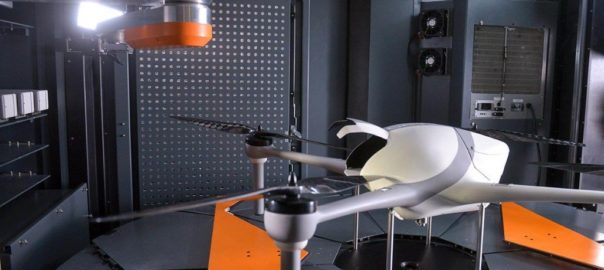
Airobotics has introduced LiDAR capabilities to its lineup of automated drone solutions, significantly reducing the time it takes for aerial data to be collected.

The announcement came at the same time as it declared record growth in 2018 and an expansion of its executive team in its new Scottsdale, Arizona headquarters.

Until a few years ago, the use of LiDAR was not possible with an aircraft as the sensors were hefty and required manual data processing, according to Airobotics. “Today, LiDAR images are captured and processed quickly in the cloud, allowing Airobotics’ customers to make effective decisions based on high-frequency, consistent data capture,” the company said.

These new capabilities will provide rapid precision scans across the value chain for industries such as mining and construction, according to Airobotics. Applications typically involve tailing dams monitoring, infrastructure inspections, haul road safety compliance, stockpile volume analytics, tracking rehabilitation progress, and more.

“The use of LiDAR significantly reduces the time it takes for aerial data to be collected, even at night or in low light, and allows for rapid turnaround time on data processing,” the company said. “Airobotics’ drones can work with various payloads. In addition to LiDAR, spatial data can also be captured using photogrammetry, video, and infra-red (thermal).”

In addition to this news, Airobotics said it had appointed former Morgan Stanley employee William Atkins as Chief Financial Officer and former Airware Chief Revenue Officer  as its own CRO.

Last week, the company received Australia aviation approval to operate automated multi-rotor drones from its remote operations centre beyond visual line of sight with no aircrew needed at the client site.

CSIRO drone autonomy spin-out Emesent finds financial backing

Emesent, a drone autonomy spin-out from Australia’s CSIRO, has raised A$3.5 million ($2.5 million) in venture capital to commercialise its first product, Hovermap.

Main Sequence Ventures, which manages the CSIRO Innovation Fund, led the funding round along with long-time Bechtel mining executive Andy Greig.

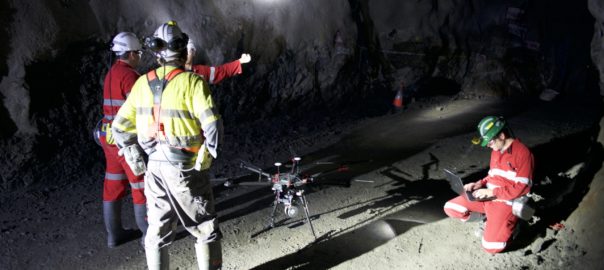
Developed by former researchers from CSIRO’s Data61, Emesent’s Hovermap technology automates the collection of valuable data in underground areas too dangerous or difficult for people to survey or navigate, such as stopes or ore passes in mines, the technology arm of Australia’s national science agency said.

“Drones installed with Hovermap can be deployed in GPS-denied environments without a human controller to create 3D maps, and record gas readings, videos and images,” CSIRO said.

Hovermap draws on a decade of research by CSIRO’s Robotics and Autonomous Systems group into drone autonomy and 3D LiDAR-based simultaneous localisation and mapping (3D SLAM) techniques.

Dr Stefan Hrabar, Co-Founder and CEO of Emesent, said: “Hovermap enables the mining industry to safely inspect inaccessible areas of underground mines, while improving the type and quality of data collected to unlock new insights.

“This includes comparing the stope design to the actual post-blast shape to detect over-break and under-break, identification of geotechnical structures and accurate post-blast volume reconciliations.”

The data gathered improves a mine’s productivity and provides a better understanding of conditions underground, all without sending surveyors and miners into potentially hazardous areas, according to Hrabar.

Before being spun out of CSIRO, Hovermap enabled the world’s first fully autonomous beyond line-of-sight drone flight in an underground mine, 600 m below the surface of Western Australia. And the Hovermap system is already being used commercially for a variety of applications by early adopters in Australia, the US, Canada, China and Japan, according to CSIRO.

A new programme targeting the underground mining sector has now been rolled out, providing early access to Emesent’s mining-specific autonomy functions to selected participants.

“The investment will give us the opportunity to build out our team from seven to 25 and make Emesent a global leader in drone autonomy and automated underground data collection and analysis,” Hrabar said.

Queensland-based Emesent has also received support from CSIRO’s ON Accelerator programme. Both Main Sequence Ventures – CSIRO Innovation Fund and ON are supported by the Federal Government’s National Innovation and Science Agenda.

Larry Marshall, CSIRO Chief Executive, said Emesent is an example of a company who has hit the “innovation sweetspot”, combining its deep domain experience in mining with digital expertise.

“This has been harnessed by the environment we have created at CSIRO where deep science combines with innovative ideas and agile minds to create game-changing technologies,” he added.

The field of automated underground drone mapping has been growing recently. Just last month, drone major Terra Drone bought a large stake in Sweden-based startup Inkonova AB, a company focused on aerial robotics for underground mining.

Emesent is partnered with CSIRO’s Data61 to compete in the US Defense Advanced Projects Agency’s new Subterranean Challenge, which aims to develop innovative technologies to rapidly map, navigate and search underground environments.

It is one of seven funded teams competing and the only team selected from outside the US.