Tag Archives: LiDAR

Fortescue expands automation focus to light vehicles at Chichester Hub

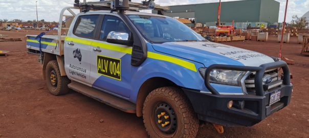
Fortescue Metals Group says the future of mining mobility is being advanced at its mines, with the successful operational deployment of autonomous light vehicles (ALVs) at the company’s iron ore mining operations in the Chichester Hub of Western Australia.

Developed by Fortescue’s Technology and Autonomy team as a solution to improve the efficiency of the Christmas Creek mobile maintenance team, ALVs remove the need for fitters to make around 12,000 28-km round trips annually to collect equipment and parts, the company estimates.

With the assistance of Ford Australia, four Ford Rangers have been retrofitted with an on-board vehicle automation system to support the driverless equipment transfer service, which will improve efficiency and safety by enabling team members to spend more time on maintaining assets.

The system features an integrated LiDAR/Radar perception system that facilitates obstacle detection and dynamic obstacle avoidance, a comprehensive independent safety management, and fail safe braking system and extensive built-in system monitoring and fault response capability.

The successful deployment of ALVs at Christmas Creek will provide the opportunity to implement a similar system at other operational sites to improve safety, productivity and efficiency, Fortescue says.

Fortescue Chief Executive Officer, Elizabeth Gaines, said: “Since the outset, Fortescue has been at the forefront of innovation in the mining industry, underpinned by our value of generating ideas. It is this focus on technology and innovation that has driven our industry-leading operational performance and cost position.

“The autonomous light vehicle project is a significant advancement of our in-house automation capability, building on our leading autonomous haulage system program which has already delivered significant productivity and efficiency improvements for the business.

“With the flexibility to introduce similar systems into other mobile assets, this project is fundamental to our future mobile equipment automation projects.”

Ford Australia President and Chief Executive Officer, Andrew Birkic, said: “We’re very proud that our award-winning Ford Rangers have been used as part of the Fortescue Metals Group autonomous light vehicle project.

“Ford, globally, is at the forefront of research into autonomous vehicles, and working with companies like Fortescue is critical to gaining an insight into specific user applications.”

Emesent’s Hovermap aids ore pass decision making at Petra’s Finsch diamond mine

Highly accurate point cloud data sets from a Hovermap scan have allowed Petra Diamonds’ Finsch mine engineers to “see” the condition of ore passes for the first time and avoid an estimated five months and R5 million ($350,000) in remediation, Emesent says.

Finsch, in South Africa’s Northern Cape, uses ore passes and underground silos to transfer ore between levels or to redirect ore for load and haul to the surface. Blockages, hang-ups, overbreak or scaling can impact the structural integrity and result in extended downtime and significant remediation costs. Accurate imagery enables mine engineers to gauge the integrity of ore passes and plan timely and cost-effective remediation programs, according to Emesent.

Historically, however, scanning and mapping inaccessible shafts and voids has been a challenge for Petra.

The company’s management sought a means of obtaining accurate visualisations of underground voids, quickly and cost effectively, without endangering the safety of Petra personnel or contractors, Emesent says.

Petra management trialled the Hovermap multiple data capture methods with Emesent partner, Dwyka Mining Services, contracted to carry out multiple scans of an indoor stockpile, ore passes and vertical shafts, and a series of access tunnels and ramps.

Hovermap is a drone autonomy and LiDAR mapping payload. It uses the LiDAR data and advanced algorithms on-board, in real time, to provide reliable and accurate localisation and navigation without the need for GPS.

Dwyka spent a day on-site conducting a series of scans using Hovermap mounted to vehicles, a DJI drone, or lowered in a protective cage. Dwyka delivered point cloud data sets for Petra’s survey team to geo-reference and analyse, within 24 hours. It also provided visualisations of the ore passes, enabling the mine engineers to ‘see’ the condition of orepasses for the first time, Emesent said.

Alex Holder, Group Planning and Projects Lead at Petra Diamonds, explained: “We lowered Hovermap down ore passes, flew the drone into draw points and even scanned our shaft and ramps by fixing the scanner to one of our vehicles. The visualisation delivered exceeded all our expectations. The data captured in one ore pass saved us significant time and effort by confirming it was irreparable. That saved us millions.”

Using Hovermap led to an immediate decision to abandon plans to expend resources remediating a compromised ore shaft. This decision saved Petra an estimated five months and R5 million.

Heinrich Westermann, Mining Engineer at Petra Diamonds, said: “The ability to power and switch the Hovermap payload between the various applications meant that we were able to scan a considerable amount of the mine in one shift. Generally, this was either impossible and, if it were possible, it would take weeks to collect those datasets and months to see the final visuals.”

The data collected by Hovermap has become the basis of a data library for the site. It is augmented regularly and used to inform operational decision making by Petra’s mine planning and survey teams, according to Emesent.

Petra intends to deploy Hovermap scanning technology to map inaccessible locations at its other sites across Africa, Emesent says.

UP’s Vehicle Dynamics Group to boost UG mine safety with new testing facility

An engineering team at the University of Pretoria (UP) has pioneered an underground procedure which tests the performance of collision avoidance systems (CAS) in an effort to improve the safety of workers on mines through reducing unwanted interaction between vehicles and pedestrians.

The Vehicle Dynamics Group (VDG) is a research unit at UP’s Department of Mechanical and Aeronautical Engineering that is actively involved in the South Africa and international mining industry.

It saw a need to develop such a system based on the continued number of fatalities that have occurred as a result of interaction with mining machines and to be in step with subsequent changes (yet to be promulgated) in Chapter 8 of South Africa’s Mine Health and Safety Act (1996) that requires trackless mobile machines to warn the operator if a significant risk of collision exists. If the operator fails to heed the warning, the machine must automatically slow down and stop safely.

“Mining machines are becoming smarter by the day, with smart, connected vehicles promising to be the mining method of the future,” Professor Schalk Els, VDG Researcher, said. “Smart mining machines are now utilising technology such as high-precision GPS and automotive radars to prevent unwanted interaction with other machines, pedestrians and infrastructure.”

Dr Herman Hamersma, also a VDG Researcher, added: “This development is a stepping stone to full autonomy – not only on mines but in urban and highway environments too. Mining machines typically perform repetitive tasks with well-defined mission profiles, which allows for the automation of many of their operations.”

The VDG has aided in the formulation of industry guidelines to analyse and improve the readiness level of collision avoidance offerings on the market, according to UP, and has developed a standard testing procedure to evaluate both surface and underground collision management systems based on guidelines set out by the Minerals Council South Africa.

CAS assessments were previously limited to above-ground testing, with UP saying its involvement has brought about change in the CAS space, having contributed significantly to the increasing maturity of commercial offerings.

“With the VDG’s recent development of an underground testing system, it is anticipated that the technology readiness of current underground CAS offerings will be even more improved,” it said.

The performance of CAS is tested by way of a stage-gate approach. The first stage gate is a lab-scale test conducted on light vehicles in a controlled environment. The CAS is installed on the light vehicles exactly as would be in a mining environment.

Dr Hamersma said: “These vehicles are equipped with brake robots that control the stopping distance and can be controlled to represent minimum brake specifications, while high-precision GPS accurately measures the speeds and positions of the vehicles. An advanced data capturing and control system is used to control the brake robot and to record the GPS data, and the decisions communicated to the test vehicle by the CAS.”

If the CAS passes the lab-scale test, it can proceed to the next stage-gate, where the system is subjected to a single interaction test conducted in an environment that is more representative of a mine. To date, testing has been limited to surface tests due to the reliance on high-precision GPS as the ground truth measurement. However, the VDG team’s recent development of an underground system makes use of LiDAR (which uses laser light to calculate distances), cameras and automotive radar to measure the distance between objects and their speeds.

The system has been tested at a training facility at one of South Africa’s underground mines, and the first live underground single interaction test is in the pipeline. The system will be used to validate the lab-scale results of underground CAS solutions in their intended underground environment where line of sight, dust and uneven, slippery road surfaces are serious concerns.

The international community has noticed the activity in this space in South Africa, and this has led to collaborations with international CAS vendors and industry bodies such as the International Council on Mining & Metals (ICMM), the ISO working group leading the development of the collision avoidance standard and a project in collaboration with Mining3, a research institute based in Australia that was funded by the Australian Coal Association Research Programme (ACARP).

Freespace Operations’ Callisto to soar higher in mining drone space

Victoria, Australia-based Freespace Operations has recently customised its drone technology to address some of the challenges associated with modern mining, resulting in the production of its Callisto Modular Industrial Multirotor.

The Callisto is an autonomous modular and multipurpose industrial drone with benefits for the resources sector including increased productivity and worker safety.

Freespace Operations Managing Director, Ken King, said: “The Callisto was designed from the ground up to be an industrial system prioritising function over form,” he said. “It’s overall levels of performance and capability exceed all other comparable systems currently available.”

King says the Callisto completes aerial surveying using advanced LiDAR sensor technologies previously only available with manned aviation. It can also deliver cargo across sites and lift product out of mines autonomously.

“The result is increased productivity because tasks can be completed quicker, with precision repeatability and without the need to place people in risky environments,” he said.

According to King, the drone system offers most benefit at sites that are remote and face logistical challenges like poor weather, undulating topography, dense vegetation and poor access.

“The Callisto has been designed for typical mine sites, so safety, durability and serviceability are built into the system,” he said. “At IMARC Online we’ll be demonstrating the Callisto to companies that undertake LiDAR aerial surveying and require long-range cargo delivery.”

IMARC Online is on now until November 27, 2020.

Emesent builds mining connections as Hovermap autonomy takes off

Having recently helped DJI’s M300 drone fly autonomously underground (through its Hovermap Autonomy Level 2 (AL2) solution) and signed an agreement with Deswik to provide surveyors and planners with more accurate data from inaccessible areas, Emesent has been on a roll of late. IM put some questions to CEO, Dr Stefan Hrabar, to find out more.

IM: First off, if no communications infrastructure is in place at an underground mine, how do Emesent’s drones stream a 3D map of the environment back to the operator’s tablet?

SH: Hovermap is smartly designed to operate beyond the communication range of the operator. The operator does not always need to see a live map since Hovermap is navigating by itself. The user can place a waypoint beyond the current limits of the map, and beyond line of sight and communication range. Hovermap self-navigates towards the waypoint, avoiding obstacles and building the map as it goes. Once it reaches the waypoint (or if the waypoint is impossible to reach), it automatically returns back to the operator. The map data is stored onboard Hovermap and when it returns back to within Wi-Fi range the new map data is uploaded to the tablet. The operator can then see the new areas that were mapped and place a new waypoint in or beyond that map, sending the drone back out again to explore further.

IM: What results have you so far received from using AL2 for Hovermap at mine sites? Were the results PYBAR got from trials at Dargues and Woodlawn in line with your expectations?

SH: Last year’s trials at Dargues and Woodlawn showcased some great outcomes for the PYBAR team, including the ability for Hovermap to capture valuable data using Autonomy Level 1 (AL1). The team saw great potential in the technology, leading to the purchase of two systems for their use. Earlier this year, AL2 flights were conducted at Dargues during the final pre-release testing phase. Even the first stope at Dargues that was mapped using AL2 highlighted the benefit of the system over traditional CMS (cavity monitoring systems). A large area of overbreak was identified in the Hovermap scan. The same stope had been mapped with a CMS, but this area was not visible from the CMS scan location so the overbreak was not identified.

A number of mines have been using AL2 to map their stopes and other areas beyond line-of-sight. With AL2, they can send Hovermap into places that previously would have been inaccessible, enabling them to obtain critical data in real time without risking the machine or personnel.

The AL2-based stope scans have been more detailed and complete (lack of shadowing) than ever before. A beyond line-of-sight flight down an ore pass was also conducted recently, with Hovermap guiding the drone down 120 m and returning safely to produce a very detailed scan.

The high level of autonomy provided by AL2 also allows remote operation of the drone. We recently completed a trans-continental demo, with a customer in South Africa operating a drone in Australia using our AL2 technology and standard remote collaboration tools. The remote operator in South Africa was able to use their laptop to experiment with the technology from the other side of the world, sending Hovermap exploring down a tunnel.

This is a taste of what’s to come, with drones underground being operated from the surface or from remote operation centres thousands of kilometers away. This will remove the need for skilled personnel on site, and reduce the time spent underground.

IM: What had been holding you back from achieving AL2 with drones/payloads? Is it the on-board computing power needed to that has been the issue?

SH: Flying underground where there is no GPS, the space is tight and there are hazards such as mesh, wires, dripping water and dust is very challenging. We overcame many of these with AL1, which makes it safe and easy for a pilot to operate the drone within line-of-sight (Hovermap provides collision avoidance, position hold and velocity control). AL1 has been deployed for 18 months with many customers around the world, clocking up thousands of hours of use. This helped to improve the robustness and reliability of the core flight capabilities.

Emesent CEO, Dr Stefan Hrabar

AL2 builds on this mission-proved base capability to provide additional features. AL2 allows the system to fly beyond line-of-sight and beyond commination range. This means it’s on its own with no help from the operator and needs to deal with any situation it comes across. There are many edge cases that need to be considered, addressed and thoroughly tested. A significant amount of effort was put into these areas to ensure Hovermap with AL2 is extremely robust in these challenging environments. For example, the drone downwash can kick up dust, blinding the LiDAR sensor. We’ve implemented a way to deal with this, to bring the drone home safely. Other considerations are returning in a safe and efficient way when the battery is running low, or what to do if waypoints cannot be reached.

IM: How do you anticipate your partnership with Deswik impacting the mine planning and survey process? Do you see this reducing the amount of time needed to carry out this work, as well as potentially cutting the costs associated with it? Have you already carried out work at mine sites that has proven these benefits?

SH: Our commitment is to help mining companies increase safety and production while reducing costs and downtime. We do this by providing surveyors and planners with more accurate data from inaccessible areas, allowing them to derive new insights. Our partnership with Deswik means we’re able to provide a more comprehensive end-to-end solution to the industry.

We see this as a very natural partnership that will improve the overall customer experience. Hovermap excels at capturing rich 3D data in all parts of the mine (whether drone based, hand-held, lowered down a shaft on a cable or vehicle mounted). Once the data is captured and converted to 3D, customers need to visualise and interrogate the data to derive insights. This is where Deswik and other mining software vendors come into play. They have powerful software tools for planning, survey, drill and blast, geotechnical mapping and a host of other applications. We’re partnering with these vendors to ensure seamless integration between Hovermap data and their tools. We’re working with them to build automated workflows to import, geo-reference, clean and trim the data, and convert it into formats that are suitable for various tasks.

Surveyors at Evolution Mining’s Mungari operation have been using this new process in Deswik. Previously they needed a third software tool to perform part of the workflow manually before importing to Dewik.CAD. The intermediate steps have been eliminated and others have been automated, reducing the time from more than 30 minutes per scan to five minutes per scan.

IM: Since really starting to catch on in the mining sector in the last five years, drones have gone from carrying out simple open-pit surveys and surveillance to drill and blasting reconciliation platforms to reconnaissance solutions carrying out some of the riskiest tasks in underground mining. In the next decade, how do you see them further evolving? What new tasks could drones carry out to improve safety, cut costs or increase productivity?

SH: Emesent’s vision is to drive forward the development of ‘Sentient Digital Twins’ of industrial sites to future-proof the world’s major industries, from mining to energy and construction. These industries will be able to move to more automated decision-making using high-quality, autonomously collected data across their sites and tapping into thousands of data points to make split-second decisions about potential dangers, opportunities and efficiencies using a centralised decision-making platform.

We see our Hovermap technology being a key enabler for this future. Drones and other autonomous systems will become an integral part of the mine of the future. Drones will be permanently stationed underground and operated remotely, ready for routine data collection flights or to be deployed as needed after an incident.

Hovermap is already addressing some of the biggest challenges in mining — including safety and operational downtime. It improves critical safety to mines, keeping workers away from hazardous environments while providing better data to inform safety related decisions such as the level of ground support needed. This then feeds into better efficiency by helping mines to more accurately calculate risks and opportunities, aid decision making and predict situations.

Hovermap can significantly reduce downtime after an incident. For example, it was used to assess the level of damage in LKAB’s Kiruna mine after a seismic event. More than 30 scans were captured covering 1.2 km of underground drives that were not safe to access due to fall of ground. In another case, one of our customers saved around A$20 million ($14.6 million) after an incident, as they could use Hovermap to quickly capture the data necessary to make a critical decision.

IM: In terms of R&D, what future payload developments are you investing in currently that may have applications in mining?

SH: We’ll keep adapting our Hovermap design to suit new LiDAR improvements as they are released. More importantly, we’ll improve the autonomy capabilities so that even more challenging areas can be mapped with ease. We’re also adding additional sensors such as cameras, as these provide additional insights not visible in the LiDAR data. Our colourisation solution is an add-on module for Hovermap, which uses GoPro video to add colour to the LiDAR scans. This allows the identification of geological and other features.

Emesent’s Hovermap to provide Deswik with complete underground mine picture

Emesent has partnered with leading software developer Deswik to, it says, enable mining companies to incorporate high-quality data captured in inaccessible locations into their mine plans and surveys.

Emesent is a leader in drone autonomy, LiDAR mapping, and data analytics. Founded in 2018 through a spin out of CSIRO, Emesent has since built a reputation for delivering high-quality data capture in the mining, infrastructure, survey and mapping industries, it said.

The company’s Hovermap is a drone autonomy and LiDAR mapping payload. It uses the LiDAR data and advanced algorithms on-board, in real time, to provide reliable and accurate localisation and navigation without the need for GPS.

“This feature makes it ideally suited to map hazardous or underground environments where traditional data capture methods are difficult and dangerous,” the company said.

Deswik, meanwhile, is a global consulting and technology company delivering efficiency-focused solutions to all sectors within the mining industry. Its mine planning and management platforms are used in over 500 mine operations around the world.

The two organisations have signed a Memorandum of Understanding to integrate their solutions to provide a more comprehensive solution to the resources sector, Emesent said.

In the first instance, a co-designed, semi-automated workflow has been created to import Hovermap data into Deswik’s design and solids modelling platform, Deswik.CAD. This workflow enables users to translate the Hovermap data within minutes, creating usable surfaces, solids and point clouds for as-built surveys, volume reporting and design updates, Emesent said.

“The data from Emesent’s Hovermap scanner can be imported into Deswik and visualised using any of the attributes that have been captured in the scan,” Stephen Rowles, Deswik Survey Product Manager, said. “The scan can be filtered, modified, and clipped to suit the user’s requirements before being processed in one or more of the dedicated functions for point clouds.”

Emesent CEO, Dr Stefan Hrabar, said the two companies were committed to working together to help mining companies increase the value of their models, by providing surveyors and planners with more accurate data from inaccessible areas.

“We’re excited about collaborating with another market-leading technology vendor in the resources sector,” Dr Hrabar said. “Integrating our respective solutions will assist customers to boost productivity and improve outputs.”

Deswik Partner Manager, Patrick Doig, said recent global events had piqued customer interest in technologies that allowed technical teams to collect high-quality data without the need to be physically present on site.

A partnership between Deswik and Emesent empowers their mutual and future customers to simplify processes, gain additional efficiencies and make value add decisions to their operations, Doig added.

Oxbotica and Navtech working on radar-based automation solution for mines

Oxbotica and Navtech have announced the joint product development of a radar-based navigation and perception system, to be launched in 2020.

The product represents the latest advancement in radar-based technology from Navtech and the partnership marks an important milestone in Oxbotica’s plans to take its automation-focused software from development towards commercial deployment.

The multi-module localisation system (radar, vision and laser) allows customers to deploy autonomy in both on-road and off-road locations, whether in mines, ports or airports and whatever the weather conditions where standard GPS or LiDAR is not possible, the companies said.

They explained: “The Oxbotica and Navtech product will not be reliant on any external infrastructure and can operate on its own or be fused with other location services driven by GPS, LiDAR or laser vision as part of Oxbotica’s modular and integrated approach.”

Oxbotica has already successfully tested its proprietary algorithms in a variety of environments and conditions as part of its Localisation module development and wider full-stack autonomy solution. This will be twinned with Navtech’s expertise in bringing autonomy sensors to market around the world.

Oxbotica says its autonomous driving software has been deployed in many different environments including cities, mines, airports, quarries and ports as part of its Universal Autonomy commitment: enabling any vehicle in any industry to drive itself with total freedom from external infrastructure dependency.

Navtech is a leading innovator, award-winning designer and manufacturer of commercially deployed radar solutions with safety at its core, according to the company. It manufactures a range of sensors that provide the performance to deliver on the promise of all-weather sensing in real world applications. This sees its sensors used in mission-critical applications around the world including security surveillance, road safety systems and industrial autonomous vehicles.

Ozgur Tohumcu, Oxbotica CEO, said: “This collaboration with Navtech is a key milestone in bringing autonomy especially to off-road domains such as mines, ports, or airports where existing LiDAR or GPS may not function effectively due to weather or operating conditions such as dust, rain, or snow.

“Navtech is a fantastic partner with their unbeatable track record of producing autonomy sensors – powering off-road autonomy around the world for nearly two decades. Incoming demand from customers and our own market research prove that there will be wide applications of this product addressing both on-road and off-road deployments.”

Phil Avery, CEO of Navtech, said: “Navtech are delighted to be working with Oxbotica on this project. Despite the potential of radar very few companies have successfully developed the necessary algorithms to use it properly. Oxbotica are world leaders in this area and, together with our high-performance radars sensors, we believe the resulting system will deliver a step change in the performance available for all-weather all-environment localisation and perception. This is crucial for automation in more challenging environments such as mines and ports.”

Scania pictures the future of mine site haulage with AXL

In September, Scania joined Komatsu in announcing it had come up with a cabless automated haulage concept for mines and construction sites that, it said, was a significant step towards smart transport systems of the future.

Having the Scania modular system at the heart of the design, the first live demo of Scania AXL took place at TRATON GROUP’s Innovation Day on October 2, at Scania’s demo centre in Södertälje, Sweden.

Following this, IM spoke with Karin Hallstan, Head of Corporate Communications and PR at Scania, to find out a little more about the concept machine.

IM: Why have you decided to launch the AXL now? Why do you think the mining and construction markets are ready for such an innovation?

KH: Autonomous transport solutions, in different levels of technological sophistication, are already well established within the mining industry. Scania already has autonomous trucks in a customer operation (Rio Tinto at the Dampier salt operation in Western Australia).

Also, mines are like closed industrial areas and have trained professionals in command of operations meaning they are well suited for automation. Autonomous vehicles can also make mining operations safer for people employed within the sector.

The reveal of Scania AXL as a concept had to do with Scania having a good opportunity to showcase this in relation to other news we also have planned.

IM: The success of autonomous equipment on mine sites – in terms of boosting productivity, lowering costs, increasing utilisation, etc – has often been predicated on having robust network communications to relay information from the equipment. How will Scania ensure all its customers leverage the technology to its fullest without insisting on 4G/5G/LTE, etc networks.

KH: A certain communications infrastructure will need to be in place to ensure the onboard communications equipment work. Which type and with which capacity may vary.

IM: What payload is the initial concept vehicle? What range of payloads do you expect to cater for in the mining/construction sector?

KH: Scania AXL is based on a 8×4 donor vehicle with a 410 hp diesel engine (G410B8x4NA) running on biofuel HVO (Hydrotreated Vegetable Oil). However, since it is based on Scania’s modular approach, it can be equipped with any engine and wheel configuration available in the Scania modular system. The Scania AXL can load up to 40 tons using existing heavy-duty components.

IM: Based on this, what type of mining operations are you aiming to sell into (coal, iron ore, copper, etc)?

KH: It is important to note that this is a concept which we are building and piloting to primarily learn from in terms of the autonomous capabilities and removing the cab from a truck, rather than something with a set plan to commercialise. We believe that we will start in open-pit mines in this learning process. That said, Scania AXL is specifically constructed with a low tipper truck body that is suitable for underground tunnels with as little as 2.8 m headroom. Above ground, the truck body could be bigger.

IM: You mentioned that this is the first time the company has built a truck that has many new components and technologies – can you expand on what these are and what results you expect to achieve by incorporating them in the AXL design?

KH: The fact that there is no safety driver as backup has led to several innovations with regards to system integration and safety related processes and technical solutions. For example, the original electronic braking system has a ‘safe mode’ that hands control back to the (manual) driver which, in this case, doesn’t exist. Situations like these must be handled with redundancy.

IM: How does the automation system you have developed for the AXL differ to other solutions on the market? 

KH: We will comment on our own solutions, not necessarily on others’. What we can say about the automation system for Scania AXL is that the vehicle creates its own picture of its environment and performs its task based on its own view of whether the path/road is drivable and what the assignment is. It is not a solution for automated guidance by GPS-signals or where vehicles follow a loop in the ground.

IM: LiDAR appears to be a big part of the company’s design for the AXL. Has this LiDAR technology been transferred from another vehicle in the Scania range? Or, is it from another sector?

KH: Most of the sensors (radar, LiDAR, antennas and cameras) are, in essence, early prototypes at this stage and are not available in the existing Scania range.

IM: Where and when do you expect to trial the AXL first? What do you anticipate this trial involving (testing out the full capabilities, trialing the self-driving, loading the machine, etc)?

KH: We have trialled it in our own test facilities. If, and when, we work with a customer in a location outside our test environment, we will disclose this broadly publicly.

IM: When could the AXL be available commercially and, going back to a previous question, what payload class is this likely to be in?

KH: This is a concept and a pilot, so we are not commenting on commercial availability.

Why the Pilbara leads the way in haul truck automation

A presentation at last month’s AusIMM Iron Ore 2019 Conference, in Perth, Western Australia, made it clear that the state’s steel raw material miners are leading the way when it comes to applying autonomous haulage systems (AHS) in open-pit mining.

Richard Price, Manager of Projects for Mining Technicians Group Australia (MTGA), has been involved in this technology space for a number of years, having initially witnessed an automation trial involving two trucks at Alcoa’s Willowdale bauxite mine, in Pinjarra, all the way back in 1994.

At the conference, his paper set out the state of play in Pilbara when it comes to AHS, explaining: the first commercial scale trial in iron ore took place at Rio Tinto’s West Angelas operation in 2008, there are two original equipment manufacturer (OEM) AHS operating in the Pilbara – Caterpillar Command for Hauling and the Komatsu FrontRunner – and the three major iron ore miners (Rio Tinto, BHP and Fortescue Metals Group (FMG)) were leaders when it comes to using autonomous trucks.

FMG is the largest operator of autonomous trucks in the Pilbara – making it effectively the largest in the world – with 128 at the end of June (according to the miner’s June quarter results). Rio, meanwhile, had 96 up and running, with BHP having a total of 50, as per publicly released data.

“FMG has plans to automate all of their trucks, including the first non-OEM trucks on an alternate OEM system,” Price said, with him adding that the company has now automated a number of Komatsu 930E vehicles using the Caterpillar Command for Hauling AHS: a world first.

“Additionally, FMG is also operating multiple Caterpillar OEM trucks onsite, in another world first having three classes of truck on the one system at the same site (789D, 793F and 930E),” he said.

While Komatsu, historically, has more time in the field with commercial autonomous applications – it surpassed 2 billion tons of autonomous haulage in November – than Caterpillar, the Illinois-based OEM has received more global success, being able to point to AHS deployments in the oil sands of Canada, the coal mines of British Columbia and Vale’s iron ore operations in Brazil.

“With regards to the on-board AHS componentry, the Komatsu system is somewhat simpler than the Caterpillar system,” Price said. “The significant difference is that Caterpillar utilises a LiDAR (Velodyne 64-layer), with RADAR, whilst the Komatsu system uses RADAR only. However there are additional differences in the on-board controls – the Caterpillar system is known for having more significant vehicle on-board computing power, versus the Komatsu system which places greater reliance on the wireless network whilst performing most of the calculations on the server side.”

Even with the on-board computing power of Caterpillar’s system, the performance of these trucks only tends to be as good as the communications infrastructure they are tied to.

Presently, only the Komatsu system has announced successful trials of using 4G Long Term Evolution (LTE) network technology as the communications system which commands the trucks, with the Caterpillar system presently reliant on wireless networking technology, “of which all current implementations rely upon (globally)”, Price said.

One of the issues with such technologies is the trucks stop driving, or operating, if they lose communications, with the trucks communicating, via this network, their position to each other and directional heading and speed.

The way the trucks re-start their driving routine is, at present, via manual visual inspection, which can be a process that takes time.

And, according to Price, a significant problematic issue with trucks stopping driving across all the Pilbara sites is the triggering of a false positive object detection.

“These are often referred to as ‘ODs’ on the various sites which utilise AHS,” Price said, with many operators blaming undulations in the road, pot holes, or small rocks for these occurrences.

Again, manual inspection is normally required as part of an operation’s procedure for re-starting the autonomous trucks.

Out in front

Despite these communication and OD problems, Western Australia still leads the way when it comes to automation with the Pilbara hosting around 75% of the circa-370 trucks operating globally.
What is the reason for this? Price highlighted five bullet points in his speech:

  • High cost of operators – annual salaries for truck operations are, in general, over A$100,000 ($68,882);
  • Ease of implementation – “the Pilbara miners generally have open ground, and have had an opportunity to trial the technology in a dedicated work area prior to a site-wide implementation,” Price said, adding that the topography has also made it simpler to install the required communications systems;
  • Scale and longevity of operations – Previously cost-benefit analysis of AHS included an approximate cutoff point of 12 Mt/y total material movement, which equates to six to eight off-highway haul trucks, Price said. All operations exceed this, as well as having long mine lives;
  • The fact that all the sites which have presently deployed AHS are currently fly-in/fly-out mines which transport the staff to site from their point-of-hire, and;
  • Experience of technology and processes in the Pilbara – miners in the region have long-term familiarity with fleet management systems and technology adoption.

Price said: “Western Australia does not necessarily have any unique or special advantage, however, it has made sense for Pilbara iron ore operators to implement AHS for the reasons outlined above.”

The benefits

MTGA’s Price pointed to several quotes from the mining companies themselves to explain the benefits of automation.

Rio Tinto, in 2018, said: “On average, each autonomous truck was estimated to have operated about 700 hours more than conventional haul trucks during 2017 and around 15% lower load and haul unit costs.”

FMG, in the same year, said it was seeing 32% productivity improvements with autonomous trucking.

Vale, meanwhile, previously told Mining.com: “The adoption of autonomous trucks at Brucutu (iron ore mine, in Brazil) is expected to reduce fuel consumption by more than 10%. Maintenance costs, in turn, should fall by another 10% and off-road truck tyres, which cost up to $40,000, are expected to have 25% lower wear. The overall gains translate into a 15% increase in equipment life, reducing investments in new acquisitions and reducing carbon dioxide emissions at the same time.”

Price said: “There are clearly differing metrics being monitored by these three operators at present. However, irrespective of the metrics monitored, AHS obviously has had a significant impact on the operating environment.

“It appears that the increase in utilisation of the autonomous trucks is the most significant benefit that they provide. The decrease in costs is also helpful, but the increase in predictability of the truck fleet is what drives the actual benefit.

“A number of materially measurable but difficult to quantify benefits exist from the rendering of trucks autonomous as well. These include less maintenance, better tyre wear (or increased tyre life), reduced fuel costs (for the same tonnage output) and better overall truck performance.”

For instance, Komatsu has previously said the optimised automatic controls of AHS reduce sudden acceleration and abrupt steering, resulting in a 40% improvement in tyre life compared with conventional operations.

And, of course, there are the numerous safety benefits that come with using automated haul trucks.

The future

While Price believes that mining will continue to become more autonomous, he said the mine of the future was likely to involve the automatic distribution of data files that trucks would work off without human involvement.

“For now, technologies such as LTE for better communications network coverage, the use of drones, long-range cameras or other autonomous ground vehicles to conduct the manual visual inspection and other autonomous equipment will be implemented,” he said.

He added: “It is likely that there will be a continuum of development over the next 20-30 years.

“Mining companies and OEMs will have a lot to learn from automotive vehicle automation. Obviously, there are more cars on the roads than there are off-highway haulage trucks on minesites. Therefore the general costs of automation kits will come down, and there will be an opportunity to conduct operations in a GPS-denied environment.

“Already, the costs of select items such as the LiDAR utilised by the Caterpillar system have halved in price since they were used a decade ago. Solid state LiDARs, as opposed to rotational, are being implemented in the automotive industry already.”

He pointed to MINExpo 2016, in Las Vegas, when Komatsu showcased its cabless, driverless truck as one development to look out for.

“It is predicted that in the longer-term future (ie 20-30 years’ time), cabs will be an additional and expensive option to add onto an off-highway heavy haulage truck,” he said.

“Whilst the future is autonomous, it will be technologically more advanced than the present technologies,” he concluded, adding that, given its head start, one would expect the Pilbara iron ore industry to deploy these technologies first.

MTGA’s Richard Price has also written a business case study on AHS, published by AusIMM – www.ausimmbulletin.com/feature/autonomous-haulage-systems-the-business-case/ – and, in partnership with Whittle Consulting’s Nick Redwood, put together an Autonomous Haulage Systems Financial Model Assessment – www.whittleconsulting.com.au/wp-content/uploads/2017/10/Autonomous-Haulage-Study-Report-Rev-F.pdf

BHP’s Jurgens presents big picture automation plan

Diane Jurgens, BHP’s Chief Technology Officer, used her time on stage at the Bank of America Merrill Lynch SmartMine conference, in London, to highlight the company’s plan to introduce full or partial automation across its entire value chain.

The miner has already introduced automation across many of its operations – from haul trucks at Jimblebar (Western Australia) to drill rigs at Western Australia Iron Ore – but Jurgens said the company has bigger automated plans.

This includes considering opportunities to accelerate truck autonomy across the company’s Australia and Minerals Americas sites – the company previously detailed plans to automate around 500 haul trucks across its Western Australia Iron Ore and Queensland Coal sites – and introducing “Decision Automation” to link autonomous processes and data from different sources together to create “near instantaneous, optimised decision making”, Jurgens said.

While she talked up the use of automation in mining – referencing the experience she has in the automotive and aerospace industries – she admitted full automation across the BHP group was unlikely.

“This is because we automate equipment and processes where it provides the highest value,” she said, explaining that investment in technology competes against all of other projects in the BHP portfolio, “and alternative uses of cash, under BHP’s Capital Allocation Framework”.

To test this, the company has built proving grounds at two active mine sites (Eastern Ridge in Australia and Escondida in Chile) to trial new innovations in geology, extraction and processes, and “develop workforce capability so that our people are equipped for the rapid pace of change that lies ahead”, Jurgens said.

Just some of the new innovations Jurgens mentioned included the use of advanced geophysics modelling to reanalyse existing drilling data. This new approach led, in November last year, to the Oak Dam copper discovery, near its existing Olympic Dam operations in South Australia.

Recently, sensors were installed at the Escondida test grounds to prototype the use of real-time data to analyse the quality and grade of ores and inform, for example, whether to divert unprocessed ore for leaching, to concentrators or waste. Jurgens said: “The key to achieving this is using data collected through the sensors and combining it with proprietary algorithms. We then apply our knowledge of the ore body to optimise the processing methods. Once in production, we expect these to improve throughput performance.”

With access to more detailed data on extracted material, machine algorithms can automate decisions to identify and divert waste, which increases plant performance and reduces processing costs, she added.

New patented leaching technologies have, meanwhile, increased metal recoveries by 10-12% and shortened the processing time by 50%, according to Jurgens. “At Spence in Chile we increased copper recoveries by about 10% and helped offset grade decline through implementing the low-cost Spence Recovery Optimisation project,” she said. “The initiative improved heap leach kinetics which meant we could maximise utilisation of the leach pads and therefore use the full 200,000 t of tankhouse capacity.”

This breakthrough also informed the successful heap leach trial at Olympic Dam, which the company has just completed.

The company’s automation and innovation journey has already resulted in significant wins, according to Jurgens.
Equipment automation is creating more efficient, standardised and safer operations, she said:

  • Autonomous blast hole drills across BHP’s Western Australia Iron Ore assets have increased drill rates by 25%, and reduced monthly drill maintenance costs by over 40%;
  • Haulage automation at the Jimblebar operation, in the Pilbara, has reduced heavy vehicle safety incidents by 80%;
  • Machine learning is being applied to maintenance on trucks in iron ore and coal – to analyse component failure history;
  • At Yandi, haul truck maintenance analytics increased truck availability to above 90% and generated recurrent cost savings. Replicating these strategies to our trucks in energy coal in the Hunter Valley, BHP has also seen an increase in truck availability;
  • Automating key components of BHP’s rail network is supporting increased capacity, more reliable dispatch and improved maintenance outcomes;
  • In Western Australia, material density scanning and laser precision have delivered an additional 2.4 t of iron ore per car while reducing safety risks of overloading;
  • The automated rail network scheduling system, which controls over 10,000 ore cars and transports about 270 Mt/y of iron ore, is becoming more effective through self-learning algorithms, ensuring trains arrive at port, on-time, and;
  • LiDAR technologies are being used to automate the loading of ships that transport BHP’s product to customers around the world.