Tag Archives: LiDAR

RIEGL and DMT collaborate on tailored mining monitoring solutions

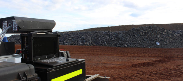
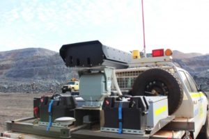
In a joint development between RIEGL and DMT, the RIEGL VZ-400i and VZ-2000i 3D terrestrial laser scanners are now being integrated into the DMT SAFEGUARD monitoring platform to, RIEGL says, offer innovative and tailored monitoring solutions for the mining and infrastructure industries.

The open architecture of the RIEGL VZ-400i and the RIEGL VZ-2000i 3D Terrestrial Laser Scanner allows customisation of the scanner for complex data acquisition and processing tasks by means of Python scripts and Python-based apps. RIEGL’s Online-Waveform-Processing technology ensures high quality data, while 24/7 fully remote operation is proven, it says. Laser scan data is processed by integrated apps in real time on the scanner, with final results visualised via a web viewer tool.

With DMT SAFEGUARD a precise integration of RIEGL’s VZ-i Series scanners into a web-based platform is available, according to RIEGL. The individual customisation options allow additional sensors to be integrated directly on site, or external data sources integrated as well. GIS functionalities allow the integration of maps in order to display the most important data, with real-time documentation options, document management, an automated real-time assistance system and sophisticated reporting completing the service.

The new system provides real-time, exhaustive geospatial information and all decision-relevant parameters such as deformation values are available on demand from anywhere on the globe, RIEGL concluded.

Exyn’s automation software to be fully integrated into Easy Aerial Osprey aerial platform

Exyn Technologies has selected Easy Aerial, a leading provider of autonomous drone-in-a-box solutions, to be one of its core airframe partners for the ExynAero™ product line.

This collaboration not only highlights Exyn’s ongoing efforts in fostering strategic partnerships but also marks the first fully-integrated autonomous LiDAR drone made in the US powered by Autonomy Level 4 (AL4), meaning Exyn’s software stack will be fully integrated into the Easy Aerial Osprey airframe, the company said. The product will be commercially available in the September quarter of 2022.

The Easy Aerial Osprey is a durable drone, made of advanced composite materials, with motor redundancy for increased safety and reliability. The Osprey’s design makes it extremely efficient for its relatively compact form factor. The hex configuration makes the airframe ideal for carrying a variety of large payloads or cargo, up to 6.6 lb (3kg), over longer distances, even in adverse weather conditions, Exyn says.

“This partnership shows Exyn’s vision for the future of aerial autonomy, the expansion of our platform partnerships, and a push to secure a US-based airframe that can meet our rigorous standards as we continue to grow,” Nader Elm, Co-Founder and CEO of Exyn, said.

The Easy Aerial Osprey is designed and manufactured in the US and will be similar to the existing variants currently operated by several US DoD agencies,enterprise end users and deployed in more than 15 different countries. The Osprey boasts a flight endurance of 25 minutes with heavy payloads and up to 55 minutes with lighter configurations. It will support modular camera and sensor attachments as well as standard LED lighting for underground illumination. Exyn’s latest venture demonstrates the relative ease of integration of their autonomy onto a new airframe and steady growth of their product lines.

“We’re thrilled to be working with Exyn to create the world’s first fully integrated LIDAR drone powered by Autonomy Level 4,” Ido Gur, CEO of Easy Aerial, said. “Exyn’s autonomy is best-in-class, and equipped on the robust Osprey airframe, survey teams will be able to log even more critical data than before while remaining out of harm’s way.”

Burgex adds ExynPak LiDAR capabilities to mine mapping offering

Burgex Inc Mining Consultants has announced newly acquired in-house capabilities to provide high accuracy mapping of surface and underground mine workings with the addition of the ExynPak from Exyn Technologies to its fleet of mining and mineral exploration solutions.

With a gimballed Velodyne LiDAR sensor and the ability to provide real-time 3D mapping with survey-grade accuracy, the ExynPak is the leader in high accuracy handheld mapping for mining and exploration applications, according to Burgex. Simultaneous Localisation and Mapping (SLAM) provides accurate, survey-grade 3D mapping in real-time without the use of GPS, it added. This delivers precision mapping in underground mining environments that have been traditionally difficult to map using modern methods.

“The ability to map underground and surface mining workings in high resolution provides an enormous advantage to mine planning and mineral exploration projects,” Burgex said. “With LiDAR capabilities of over 600,000 points per second and a 360° horizontal field of view, it is possible to quickly identify slopes, faults and other geological features in real time. In addition to generating <3 cm accuracy point clouds in real time, the ExynPak is also equipped with two FLIR Chameleon3 RGB cameras that are capable of colourising points – providing yet another layer of functionality to geologic mapping and mine planning projects.”

Leveraging portable LiDAR with aerial data collection provides a new level of flexibility in modelling for mining and mineral exploration projects that is not offered at many, if any, other mining consulting firms in the US, Burgex said. Combined with aerial mapping, the Burgex team can pin underground and surface LiDAR surveys to geo-referenced base surveys and maps – creating a completely modelled project that can be used for mine planning, exploration programs, and more.

Additionally, Burgex Mining Consultants has recently added a DJI Matrice 300 RTK (M300) to its fleet of UAVs, providing even greater capabilities for aerial data collection.

“Not only can the M300 collect data more efficiently that other UAVs, but it can also simultaneously carry up to three payload sensors,” the company said. “The M300 has a max transmission range of up to 9.3 miles (15 km) with a 55-minute maximum flight time. The IP45 water and dust protection ratings and expanded operating temperatures will enable operation in a broader range of field conditions.”

Stuart Burgess, CEO and Co-Founder of Burgex Inc, said: “We are very excited about the addition of this new equipment and the new services we will be able to provide for our clients. From underground to surface, we’ll be able to map and model projects quickly and with centimetre accuracy, which is something that used to be very difficult and expensive to achieve, especially in underground environments. These new tools represent the next generation of mining and mineral exploration advancements.”

Hitachi to leverage Baraja Spectrum-Scan LiDAR tech on autonomous mining vehicles

Baraja, the creator of Spectrum-Scan™ LiDAR technology for autonomous vehicles, has announced its first volume commercial deal for long-range LiDAR with Hitachi Construction Machinery.

The multi-year commercial partnership will give some of the largest mines and mining operators global access to high-performance LiDAR systems capable of withstanding the world’s most hazardous mining environments, according to Baraja.

Baraja has worked closely with Hitachi Construction Machinery, a strategic partner and investor, to develop a LiDAR, Spectrum Off-Road using the core Spectrum-Scan platform, configured specifically for autonomous and semi-autonomous mining machines and vehicles.

Earlier this year, Baraja partnered with automotive supplier Veoneer to deliver Spectrum-Scan LiDAR for L2+ through L4 autonomous vehicle applications.

Spectrum-Scan, Baraja says, is built for the automotive industry and mining machines and vehicles at scale and will continue to evolve to implement its technology into many different types of vehicles to meet the world’s ever-changing needs.

“Baraja’s Spectrum-Scan LiDAR technology is built to enable true autonomy in mining, optimised for heavy industrial settings, and delivers high-resolution point clouds tested in a ruggedised system capable of withstanding hazardous environments,” the company says. “Baraja’s Spectrum-Scan technology has been tested in mine sites around the world, and proven outperformance in dust and fog, designed for high thermal tolerance (-40°C to +85°C) and built to endure shock and vibration in the harshest of environments on the planet.”

Federico Collarte, CEO and Founder of Baraja, says: “With this high-volume commercial deal, Hitachi Construction Machinery confirms Baraja’s maturity in long-range LiDAR by moving our technology to the real world at scale. This is a significant indicator that Baraja’s long-range LiDAR technology trumps the competition given the ruggedisation and reliability of the technology in mining environments. As a continuation of our existing relationship with Hitachi Construction Machinery, this will include the funding and testing partnership. The data and durability testing under this partnership will enable a step-change in LiDAR performance and durability in all sectors including autonomous vehicles.”

Hideshi Fukumoto, Vice President, Executive Officer and CTO, Hitachi Construction Machinery, added: “Following our strategic investment in Baraja earlier this year, this commercial deal demonstrates our continued confidence in Spectrum-Scan LiDAR as a high-performance system. After comprehensive testing with Baraja, we have been able to work closely with Baraja to accelerate the development of Spectrum-Scan LiDAR products with mine site specifications and the commercialisation of advanced autonomous driving and mining.”

Delta Drone to fly UAV-based LiDAR units at Newmont’s Ahafo gold mine

Global drones-as-a-service provider Delta Drone International says it has been re-appointed by Newmont Ghana Gold Ltd, a subsidiary Newmont in Ghana, for a light detection and ranging (LiDAR) project on its Ahafo mine.

Delta Drone International will provide a drone-based LiDAR solution to create an accurate 3D model of the earth and its surface characteristics to map new areas for the mine and mitigate potential risks prior to mine expansion construction commencing, the company says.

Delta Drone International CEO, Christopher Clark, said: “To continue working with Newmont Corporation, one of the world’s leading enterprise gold mining companies, who is using advanced drone techniques for several types of project applications, is a testament to our specialist expertise and drones-as-a-service model.”

He added: “Using the latest in drone LiDAR technology, we can fly with this sensor in a fixed-wing drone, allowing us to map new areas and essentially compete with manned LiDAR, but at a lower price point.

“We are seeing increased demand to use our LiDAR capability to create ‘digital elevation models’ that allows companies to see below thick forest and other surface vegetation and more accurately determine site suitability for certain types of infrastructure and how a site can be used.”

HARD-LINE readies Auto RockBreaker, TeleOp Assist and Brow Alert for MINExpo crowd

HARD-LINE plans to unveil a diverse line-up of new mining products geared towards automation and safety at MINExpo 2021 next month.

The company’s Auto RockBreaker, TeleOp Assist and Brow Alert will be just some of the company’s booth highlights from September 13-15, in Las Vegas.

HARD-LINE’s Auto Rockbreaker is going to “disrupt” the mining industry, according to the company.

“For the first time ever, operators will have the ability to automate many rockbreaking tasks” HARD-LINE said. “With Auto Rockbreaker, mining companies will be able to reduce maintenance and operator training costs, decrease wear and tear while extending the life of all rockbreakers.”

The system has many functions, including auto deploy and auto park, as well as other features making the operator experience that much more intuitive with its 3D User Interface, it said.

TeleOp Assist is the latest addition to the company’s TeleOp suite, which equips the base TeleOp system with intelligent steering assistance and collision detection to keep machines off walls while driving.

Using real-time 3D LiDAR scans, Assist will automatically steer to handle the articulation adjustments required to keep the machine as centred as possible within the drift, the company said.

“With Assist’s adaptive technology, a pre-scan of the drift is not required – providing significant cost savings,” HARD-LINE said. “The system does not require any training when moving from one level to another.”

Brow Alert, meanwhile, is an added level of protection for underground mining operations.

It serves as an add-on system designed to deter an operator from manually driving a vehicle past the brow line of a stope by using sensors and modules.

The system is easy to install, reduces risk of workplace injuries and fatalities, encourages accountability and keeps operators a safe distance from the brow, the company says.

Auto RockBreaker, TeleOp Assist and Brow Alert will be joined by the likes of RRC (Radio Remote Control), TeleOp system, vehicle conversion kits (drive-by-wire), and HARD-LINE’s low-profile loader series (LP401 and LP301) on the company’s MINExpo booth.

Delta Drone to use LiDAR-equipped UAVs at Barrick’s Mali operations

Delta Drone International is expanding its operations into Mali with a contract to deliver “advanced LiDAR services” to Barrick Gold.

For the first time in the region, the drone-focused company will use advanced light detection and ranging (LiDAR) solutions to examine mining site expansion options through its mining specialist brand, Rocketmine, it said. It will do this through a fleet of mining-specific drones and expert mining pilots.

Barrick operates the Loulo-Gounkoto mining complex in Mali, which comprises two distinct mining permits, Loulo and Gounkoto, and is situated in the west of the country, bordering Senegal and adjacent to the Falémé River. Both Loulo and Gounkoto are owned by Barrick (80%) and the State of Mali (20%). The complex produced 193,014 oz of gold in the March quarter.

The one-week operation of these drones will deliver Barrick the data required to guide decision making while continuing to focus on day-to-day mining operations, Delta Drone said. Rocketmine will also manage the necessary requirements by Mali’s local civil aviation authority to ensure all services conducted on the site are compliant.

Oxbotica and TRL draft off-highway automation Code of Practice

Oxbotica and TRL have piloted the use of what they say is the first Code of Practice for the safe and cost-effective deployment of autonomous vehicles in unstructured off-highway environments, such as mines, with a live trial conducted in a quarry using a number of off-road vehicles.

The Innovate UK-funded consortium has developed and demonstrated capabilities to adapt and retrofit autonomy, using robust low-cost sensors, to any vehicle, as well as drafting a Code of Practice that identifies the key elements for safe and efficient deployment of autonomous vehicles in off-road industries, the companies say.

Off-road environments feature more varied hazards and less structured scenarios than on-road settings with no universal highway rules, such as speed limits or junction etiquette. A Code of Practice helps standardise across industries and allows learnings from each domain to be shared, Oxbotica and TRL say.

“Off-road vehicles also have to interact with a wide variety of unpredictable objects in their environment, either because they block the vehicle’s path, such as undergrowth or tree branches, or because engaging with them is part of the vehicle’s primary function, such as harvesting or excavating,” they added.

With autonomous vehicles commonplace in many industries such as mining, working to deliver safety, efficiency and productivity, the Code of Practice will help organisations transition to new working practices and harness the potential benefits with no impact on safety, according to the firms.

To demonstrate the Code Of Practice and highlight its potential to work across a range of vehicles and industries, Oxbotica and TRL deployed a Ford Ranger and Range Rover Evoque, retrofitted with Oxbotica’s world-leading autonomy software platform, in a UK quarry in April 2021. The vehicles were fitted with a full suite of sensors, including LiDAR, Radar, and stereo cameras.

Oxbotica’s technology has already operated in a range of environments without road markings across Europe, Asia and America. Its software seamlessly transitions between sensors to operate across multiple domains and environments, according to the company.

“The software is capable of using sensors independently or fused in any combination, meaning vehicles can drive with or without maps, depending what is available at any given time,” Oxbotica added.

Ben Upcroft, VP of Technology at Oxbotica, said: “Our autonomy software platform is capable of being integrated with any vehicle, in any environment. In order to harness the true power of this technology, operational regulations need to be developed in unison to ensure safe and efficient deployment. Consortiums such as this are a key stepping stone in ensuring the safe operation of autonomous vehicles in complex scenarios, and enabling the scale up to full commercial deployment in industry settings.”

Dr Ianto Guy, Project Lead at TRL, said: “This Code of Practice seeks to provide high-level guidance to organisations, in all sectors of the off-highway industry, on the ways in which working practices should be adapted to ensure that the adoption of autonomy is as smooth and safe as possible. The aim is that this code will support safe practice, build public confidence, and encourage the cooperation between organisations across all industries employing off-highway autonomous vehicles.

“It is hoped that off-highway industries will use this code of practice as a starting point for discussion and build on the recommendations made here to develop comprehensive best practice guidelines.”

Arvizio and Sight Power look to optimise the mining process with digital collaboration

Arvizio has announced a partnership with Sight Power that, they say, will see the two firms offer stakeholders a seamless integration of mining data, 3D models and LiDAR scans to be shared between Sight Power’s Digital Mine™ platform and Arvizio’s Immerse 3D augmented reality (AR) solution.

The combination provides the industry with a powerful, integrated suite of mining operations software and AR to optimise the mining process by reducing costs, improving efficiencies, increasing productivity and enhancing safety, the companies say.

“Digital transformation is a major trend across all aspects of mining and AR is emerging as a key component to incorporate and visualise mine planning data in the design, planning, operations, resource management and investor relations processes,” the companies said.

Digital Mine is a system for collecting and processing detailed information relating to all operations and work processes in the mining enterprise, according to Sight Power. This information, when merged with modelling, monitoring and distributed sensor systems, offers a cohesive solution to automate daily, routine operations for geologists, mining engineers, mine surveyors and other specialists resulting in increased labour productivity and reduction in technical errors, it said.

Arvizio’s Immerse 3D allows 3D models and LiDAR scans, used with Digital Mine, to be visualised in AR. The hybrid-rendering and advanced model optimisation capabilities of Immerse 3D can visualise LiDAR scans and geological models from mining operations that may cover many kilometres and include multiple layers.

“Further, Immerse 3D enhances the Sight Power Digital Mine platform by extending the capabilities of Digital Mine to include multi-user, multi-location AR visualisation and collaboration in fully synchronised sessions utilising web meeting platforms such as Microsoft Teams and Zoom,” the companies said.

Sergey Reznichenko, CEO at Sight Power, said: “Our work with leading mining companies using Digital Mine demonstrated that combine operational technology, monitoring systems, devices and spatial datasets into a single workflow system streamlines mining operations at every phase.

“We are delighted to team with Arvizio to integrate Immerse 3D AR visualisation into our workflows and use augmented reality to empower stakeholders around the world for a more efficient exchange of information, problem solving, verification of key operations and safety systems in their mining projects.”

The Immerse 3D platform extension enhances capabilities of Digital Mine technology using AR in these, and other, scenarios:

  • Supporting staff training and equipment repairs to reduce operational costs and downtime;
  • Extending digital twin capabilities for processing plants for real-time monitoring;
  • Real-time virtual presence at mining site; and
  • On-going evaluation of mine evolution models to identify issues and avoid costly overruns.

Hyperspectral imaging technology tested at Western Australia gold, iron ore mines

The University of Queensland and research partners Plotlogic Pty Ltd have developed new automated mining technology that, they say, will facilitate automation of the mining process while improving operating efficiency.

The research has shown how artificial intelligence can use scans of the mine face to almost instantly identify valuable minerals and waste rock, allowing each stage of the mining process to be planned more effectively in advance, UQ said.

Professor Ross McAree, Head of School of Mechanical and Mining Engineering from UQ, said the new technology used visible and infrared light to automatically classify materials.

“Each mineral has its own characteristic response to different wavelengths of light, so by scanning the mine face with our system we can map out the minerals present in the rock and their concentration (ore grade) almost instantaneously,” Professor McAree said.

This real-time mapping allows the mining process to be planned out before digging even starts, according to the researchers.

“Beyond this immediate efficiency gain, the enhanced ability to recognise ore grade could also underpin future autonomous mine systems,” Professor McAree said. “Machines equipped with this imaging system would be able to recognise ore grade as they were excavating it. Linked to artificial intelligence, this could allow automated machinery to operate in the mine environment, removing workers from hazardous parts of the mining process.”

Real-time ore grade classification at the mine face could also enhance mine scheduling and improve resource recovery and minimise processing waste, the researchers claim.

The project was supported by the Minerals Research Institute of Western Australia (MRIWA), with MRIWA CEO, Nicole Roocke, saying investment into research like this helped position Australia’s minerals industry at the leading edge of technology development.

“This imaging approach could prove particularly valuable where rapid extraction and consistency of ore grades could provide a competitive advantage to those leading the way,” Roocke said.

The project, which was conducted in 2018-2019, had a total grant value of A$850,850 ($653,322). In addition to MRIWA, UQ and Plotlogic, CITIC Pacific Mining and AngloGold Ashanti were also involved, hosting trials at the Sino iron ore and Tropicana gold mines, in Western Australia, respectively.

It was based off the OreSense® prototype system, developed to meet the needs of the research project, as well as offering a commercial pathway for early industry adoption of the technology.

“The prototype delivers a system capable of acquiring, processing and classifying hyperspectral data in the field and in real time, mapped to terrain and geo-referenced for integration with mine maps,” the project partners said. “In order to be the most general and applicable to all minerals, the hyperspectral imaging capabilities cover the visible to short wave infrared spectrum (400-2,500 nm).

“The surveying capabilities of the system rotate in more than one axis to perform face scans and build a 3D data-cube from two individual line-scanning hyperspectral sensors. The system spatially and spectrally fuses the data cubes from the two sensors to provide a single data-cube for an entire scene. The system also performs on-board corrections and post-processing of the hyperspectral data to support real-time ore grade classification.”

The prototype used on site during the trials consisted of a sensor head with LiDAR and hyperspectral cameras, a pan-tilt unit and a GNSS receiver among other elements (see photo above).