Tag Archives: exynAI

Trimble and Exyn pool technologies to create autonomous site surveying solution

Trimble and Exyn Technologies have announced a strategic collaboration to explore the use of autonomous construction surveying technology through integrating Boston Dynamic’s SpotⓇ robot, the ExynPak™ powered by ExynAI™ and the Trimble® X7
total station.

This solution will, the companies say, enable fully autonomous missions inside complex and dynamic construction environments, which can result in consistent and precise reality capture for production and quality control workflows. It also has potential for mining.

“The integration of autonomous surveying technology into a construction workflow has groundbreaking potential,” Aviad Almagor, Vice President of Technology Innovation, Trimble, said. “It can improve operational efficiency and transparency throughout the build lifecycle while also transforming worker safety for potentially hazardous data collection.”

Autonomous robots powered by ExynAI, can sense and avoid obstacles, dynamically adapting to the ever-changing complexity of construction environments, according to Exyn. To ensure the utmost safety and efficiency, the ExynPak mounts and integrates with a robot, supporting level 4 of autonomous exploration missions without requiring the robot to “learn” about its environment beforehand. A surveyor defines a 3D volume for a mission and the integrated robotic solution handles the complexities of self-navigation without needing a map, GPS or wireless infrastructure, the companies explained.

The integration of the Trimble X7 provides high-speed, high-accuracy 3D laser scanning to capture the state of the environment, according to Trimble. The captured data can be uploaded to the Trimble Connect® collaboration platform and shared with project stakeholders for further analysis, including a comparison to Building Information Models and previous scans to monitor quality and progress. The end result is a map of unprecedented detail and accuracy collected with minimal human intervention and risk.

Nader Elm, CEO of Exyn Technologies, said: “Industry has been waiting for reliable and robust autonomous technology to transform difficult and dangerous activities. Exyn’s technology is helping to enable a new front in human-robot collaboration. By working with pre-eminent leaders such as Trimble, we aim to create adaptable, state-of-the-art systems to tackle the complexities across construction and industrial environments.”

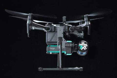
Exyn’s drone-based mining autonomy ambitions taking flight

Having already achieved the highest documented level of aerial autonomy – level 4A – with its drone-based solutions, Exyn Technologies is striving for further industry firsts, Raffi Jabrayan, VP of Business Development and Commercial Sales, says.

One of its more recent breakthroughs came in Germany at the K+S’ Werra mine site, where a team demonstrated the use of the ExynAero™ and ExynPak™ at an underground salt mine.

Over the course of three days underground, Exyn’s field engineers successfully flew multiple autonomous missions in hard-to-reach areas while capturing rich, high-fidelity point clouds in a fraction of the time it would take traditional cavity monitoring systems, according to the company.

Jabrayan explained: “Several drone companies had previously attempted an autonomous mission to scan the immense cavities this specific site has, but the dust interference meant most of these missions ended within seconds.

“We were able to fly in some cavities completely beyond visual line of sight, mapping areas in a fraction of the time the teams would normally take for such manual inspections. In all, we were able to carry out a six-minute autonomous flight at the site.”

While the company did not carry out any specific modifications to its ExynAero platform to conduct such a flight, Jabrayan acknowledged that ongoing design and software improvements over the last year had enabled the company to accurately detect both dust and thin wires underground.

In addition to this, the company also displayed the capabilities of its handheld ExynPak solutions while on site in Germany.

The ExynPak, according to Exyn, can provide the world’s first real-time colourised point cloud visualisation on a handheld LIDAR scanner, capturing precise, colourised 3D models 20-30 times faster than a traditional stationery tripod or terrestrial scanner.

Powered by ExynAI™, the ExynPak ‘drapes’ real-time RGB information captured through two hemispherical fixed cameras onto point clouds created by a gimballed Velodyne LIDAR Puck LITE, providing operators a complete colourised 360° view of their environment, Exyn says.

At the Werra mine site, the Exyn team was able to capture a colourised cloud where the stratification of the rock could be clearly seen in the scan, enabling the K+S team to obtain data it would likely never be able to replicate in any other way, according to the company.

Jabrayan says such information could see operators plan their mining processes around the colourised captures, following mineralisation identified by the scans to ensure no economic ore had been missed after mucking out.

At the Werra mine site, Exyn’s field engineers successfully flew multiple autonomous missions in hard-to-reach areas while capturing rich, high-fidelity point clouds in a fraction of the time it would take traditional cavity monitoring systems


The ExynPak is likely to become a core part of Exyn’s next aerial autonomy offering for open-pit mining, powered by ExynAI, which enables safe flight in the most dangerous industrial environments.

“We have done some work in terms of moving our flights to the surface,” Jabrayan said. “It could cover various aspects – tailings monitoring, highwall scans…there are lots of requirements for it. We are actively working on integrating GPS into our ExynAI stack for outdoor autonomous flights, however, it’s not ready to be pushed to customers just yet.”

The company is currently working on surveys of ground-based resources, such as stockpiles, using a handheld ExynPak, plus carrying out aerial flights in manual mode.

Reaching the level of autonomy it has underground will most likely involve the help of its collaboration partner, EY, and a third company providing “software and visualisation input”, Jabrayan says, adding that he expects to see this autonomous solution come to light in 2023.

Earlier this year, Exyn, in partnership with Maestro Digital Mine, presented an aerial drone fitted with a Maestro gas monitoring Industrial Internet of Things (IIoT) device.

This new gas monitoring drone, which integrates critical gas sensors onto the ExynAero and ExynPak platforms, is effectively the “quickest and safest mobile gas monitor on the planet”, Michael Gribbons, CEO and Co-founder for Maestro, said.

Powered by ExynAI’s multi-sensor fusion capabilities, gas sensor readings are captured while the robot is in flight and displayed in real time via a ruggedised tablet, Exyn explained. These sensor readings are saved with precise coordinates in a high-fidelity point cloud that can be exported and examined in a variety of mining software.

Jabrayan says a lot of mines have reached out to the companies since first presenting the solution at the SME MineXchange Annual Conference & Expo in Salt Lake City, earlier this year.

“They are interested in the benefits such a solution could provide in terms of safety and productivity,” he said. “By flying the gas sensing drone underground soon after a blast, it could take the necessary readings and issue a notice to another system that it is safe to re-enter the area.”

This could see more mines shift away from re-entry processes based on out-of-date manual gas readings, to a system that is much more accurate and shaves – potentially – hours off operational downtime.

Exyn is closing in on a long-term trial agreement with at least one miner in Australia looking to test out this gas-sensing drone solution, according to Jabrayan.

“The long-term plan is to develop a drone-in-a-box solution that can reside underground and be flown immediately after a blast to offer the quickest possible readings,” he said. “Remote autonomous mapping of this type could see Exyn provide data to shift operators as they are heading underground, allowing them to get a picture of the environment ahead of reaching the location.”

The incorporation of such data into mine site operational processes could see drone-based solutions become vital to the running of mines in the future, and Exyn, through its post-processing pipeline, ExSLAM, is looking to enable this.

ExSLAM extracts the raw cloud from robot logs and refines it for third-party software, using a factor graph optimisation algorithm to create low-drift point cloud maps.

Jabrayan says the company continually receives plaudits from customers about the ease of use of this solution, explaining that Exyn is one of the few companies that georeferences its maps inside an existing coordinate frame.

“From there, we are able to detect all the survey points, download them, georeference them and push the data to any end-user software,” he said.

Exyn, Jabrayan says, is software agnostic when it comes to this process, but he did admit the company was in advanced talks with some leading mining software companies that could see its mapping data integrated directly into their platforms.

“We are also working with certain companies to use robotic process automation to make it a one-button process to scan, go directly into the end-user software, and create a mesh that can be used,” he said.

“We remain focused on using our technology and R&D to provide the best solution to customers in order for them to be as productive as possible and, of course, work in a more efficient and safe manner.”

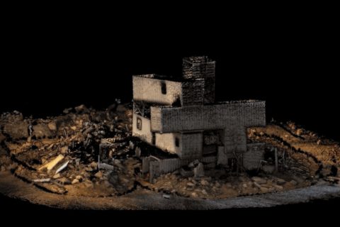
Exyn Technologies accelerates colourised 3D model capture with ExynPak

Exyn Technologies has unveiled what it says is the world’s first real-time colourised point cloud visualisation on a handheld LIDAR scanner, the ExynPak™.

This accomplishment marks one of Exyn’s many contributions to autonomous robotics across several industries including mining, infrastructure inspection and construction, it said.

Even in its early beta phase, ExynPak users can capture precise, colourised 3D models 20-30 times faster than a traditional stationery tripod or terrestrial scanner, according to the company. Powered by ExynAI™, the ExynPak ‘drapes’ real-time RGB information captured through two hemispherical fixed cameras onto point clouds created by a gimballed Velodyne LIDAR Puck LITE, providing operators a complete colourised 360º view of their environment.

Coming with a three-hour battery life, the ExynPak is capable of capturing dozens of scans in a single shift with a real-time feed ensuring maximum coverage, Exyn said. And further refinement through Exyn’s proprietary post-processing pipeline, ExSLAM, can correct drift to circa-0.1% per distance travelled.

Jason Derenick, CTO, said: “We’ve seen photogrammetry and other post-processed LIDAR scans colorise point clouds through photos and/or RGB data, but this is the first time colourised point clouds have been streamed to an operator in real time. Even in its BETA phase, we’re thrilled with what the team has created.”

The untapped potential of high-fidelity, precise 3D models has already revolutionised workflows in geological studies (mining) and will continue to revolutionise workflows in construction, reality capture, digital twinning, industrial inspection and more, according to Exyn. Equipped with a colorised ExynPak, a one-to-two person surveying team will be capable of capturing entire structures, tunnels and GPS-denied environments in a matter of hours, rather than days or even weeks.

Nader Elm, CEO: “The ExynPak is a powerful new tool with broad applications in many ‘physical’ industries such as construction, infrastructure development and inspection, mining and much more. You can set it down, initialise and begin capturing a realistic 3D model of your environment in minutes and with minimal training.”

Exyn and Sandvik OptiMine auto drone integration tested at Rupert Resources project

Exyn Technologies has announced the expansion of its strategic partnership with Sandvik Mining and Rock Solutions to integrate its data into Sandvik’s analytics and process optimisation suite, OptiMine®.

By synthesising critical data and capabilities, Exyn and Sandvik are helping mining customers transform their underground operations to be safer, more productive and more efficient, the companies say.

Back in July, the two companies signed an agreement to work together “to provide efficient solutions for mapping and visioning underground mines, which will make a substantial difference when it comes to mine locations that are hazardous, hard to reach or conventionally time-consuming to survey and inspect”.

In the latest release, the two said: “Using Exyn’s industrial-grade autonomous drone, ExynAero, mining companies can harness completely pilotless flight to access impossible-to-reach data with maximum safety. The data collected is processed using Exyn’s on-board 3D mapping technology – powered by ExynAI – which is then integrated with Sandvik’s OptiMine Mine Visualizer solution for analysis and optimisation of underground mining production and process.”

The partnership allows mining customers to benefit from comprehensive underground aerial 3D mapping with progressive visualisation that increases overall transparency of mining operations – including for GPS-denied, hard-to-reach, or hazardous areas, or locations that would be time-consuming to survey and inspect using conventional methods, according to the companies.

Exyn and Sandvik deployed this integrated solution at gold exploration and development company Rupert Resources’ Pahtavaara project in Finland, using the ExynAero drone to autonomously create a 3D point cloud of an underground stope. This 3D data was then uploaded to Sandvik’s OptiMine Mine Visualizer and georeferenced to the CAD mine model for further analysis and visualisation.

David Hallett, Vice President, Business Unit Automation, Sandvik Mining and Rock Solutions, said: “This step in our partnership with Exyn is critical. Our teams have been working closely together to ensure the connection between Exyn and Sandvik’s systems would be seamless and easy for operators to use. When this feature gets rolled out to the market as part of OptiMine, it will allow our customers to analyse Exyn’s high-resolution, aerial maps in OptiMine.

“After this demonstration, we look forward to further developing our partnership and integrating our hardware and software systems in the coming months.”

Nader Elm, CEO and Co-Founder of Exyn Technologies, added: “We’re very proud to expand our partnership with Sandvik and to deliver the key benefits of safety and operational efficiency to all the humans involved in the mining industry.

“By offering world-class software and technology, we have given customers the ability to map areas underground they could never before reach. Our end goal is to be an integral part of fully autonomous mining operations and I’m confident that through our partnership with Sandvik, we’re one step closer.”

Exyn and Sandvik have more product integrations in the plans, they said.

Exyn Technologies expands mapping reach with two new products

Exyn Technologies has announced two new products to expand its ability to collect data from challenging and previously-unmappable environments, and enable customers to have better solutions.

The ExynAero (pictured) is the latest aerial robot and an upgrade from the previous generation’s A3R™. Fully autonomous, the ExynAero allows for mapping of any environment (including GPS-denied, human-inaccessible, industrial environments without a pilot), keeping employees safe and maximising beyond-line-of-sight-and-communications data collection, the company says.

This new technology builds on Exyn’s previous iterations based on its ExynAI software, which can mesh multiple data streams in real time. The ExynAero is also able to leverage various sensors and platforms that can be merged together via automated software to build a robust and complete map of an environment in real time, even with multiple units running simultaneously, the company says.

Its features include robust 270° view, providing detailed in-depth visuals of stopes in full HD colour, super-bright lighting and LiDAR to provide top acuity, shooting over 300,000 beams per second for highly accurate visualisations. The agile navigation and flight stack improve the ExynAero’s stability and robustness in tight spaces, and the ExynAero can easily transfer data to teams who can analyse it, Exyn says.

Nader Elm, CEO Exyn Technologies, said: “The ExynAero represents the future of data collection across a number of applications and industrial environments. The product is the first of its kind to offer true aerial autonomy.”

The ExynAero can fly itself in the most challenging and unknown environments, collect the data, and merge the streams with ExynAI on board, according to Elm. This allows for maximum data collection and a “radical improvement” in safety for workers around the world who are placed in difficult and sometimes potentially dangerous conditions, he said.

“We’re hoping with the launch of this product, and the additional modalities offered by the ExynPak, that our customers will be able to collect the data they need easily, regardless of limitations,” he said. “The benefits of this will lea

d to not only significantly greater worker safety, but also considerably improved productivity and efficiency.”

The ExynPak (left), meanwhile, provides a new portable format that enables users to unstrap the autonomy features of the ExynAero and capture data with the built-in tools via other modalities – such as hand carry or vehicle mount – for situations where complete autonomy is not needed or practical.

Exyn’s autonomous aerial robot systems are most commonly used for industrial applications such as mining, construction, nuclear power, and military surveillance/reconnaissance. The ExynPak will allow for an expansion of the potential uses of Exyn’s core technology applications and environments to existing infrastructure or transportation modes that don’t require an aerial or autonomous component, the company said.

The Exyn team plans to continue to develop new products that help support mapping and data collection regardless of format, with more products coming out in 2021, it said.

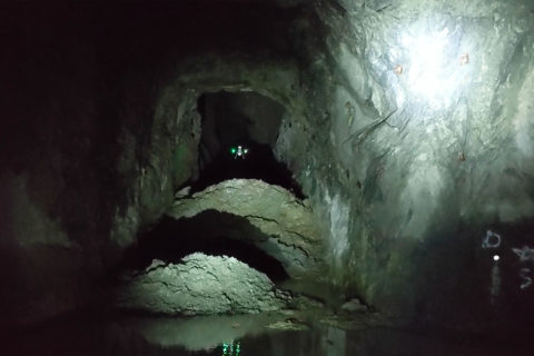
Exyn drones help Rupert Resources map Pahtavaara gold mine

Exyn Technologies says it has completed a successful mission for Rupert Resources at its historic Pahtavaara gold mine in northern Finland.

By harnessing Exyn’s autonomous drones, Rupert Resources was able to produce highly detailed 3D models of the mine, which is otherwise completely inaccessible to traditional CMS tools or even manually piloted drones, Exyn said.

“Rupert Resources needed to plan for a potential restart of operations by estimating tonnage previously removed from the mine, as well as calculating the remaining ore in heavily restricted areas,” the company said.

Exyn’s fully autonomous aerial robots mapped 30 stopes in three days with a single drone. In addition, Exyn mounted a version of its robot to a car to scan all access drifts which, together with the stope maps, provided a complete mine map in under four days.

Jukka Nieminen, Managing Director of Rupert Finland, said: “Rupert is actively seeking new technologies where we think big gains can be made in terms of safety, productivity and accuracy.

“Exyn achieved accurate assessment of the volume of remaining stopes at Pahtavaara with an unprecedented level of detail, and obviously the use of remote technologies means that this was achieved with a greatly reduced degree of risk. We have no hesitation in recommending this technology.”

Exyn’s autonomous drones are built on the exynAI™ platform, enabling aerial robots to fly intelligently without a human pilot using a multitude of high-tech sensors and AI-based software, the company says. The system operates without the need for GPS or external communications, and is deployed as an all-in-one software and hardware package.

Raffi Jabrayan, Director of Markets & Industries, Exyn Technologies, said: “Our mission with Rupert presented some of the most difficult and seemingly impossible challenges to navigating, analysing, and assessing a mine – which therefore makes it exemplary in demonstrating the heights of Exyn’s capabilities.

“Our AI-based software and state-of-the-art sensors were able to get the job done quickly and safely, proving once again that no exploration task is impossible for Exyn drones.”